School nearby Colegio Cambridge
Guatemala
School nearby Colegio Cambridge
Colegio Cambridge
Huehuetenango, Guatemala
contacts phone
:
+502 7764 7743
Latitude:
15.3197391
, Longitude:
-91.4847433
larger map & directions
read more
nearest School
43 m
Escuela Oficial Urbana Mixta Julio César Merida
1 calle, Zona 8, Huehuetenango
School
read more
171 m
Liceo Mixto San Jose
Huehuetenango
School
read more
234 m
Colegio Bilingüe Esperanza
Huehuetenango
School
read more
280 m
mm more music
Huehuetenango
School
read more
283 m
centro educativo tecnologico sion
Huehuetenango
School
read more
301 m
COLEGIO PRIVADO MIXTO EVANGÉLICO OASIS DE ENSEÑANZA MI-EL
Huehuetenango
School
read more
507 m
Liceo Dame
Huehuetenango
School
read more
539 m
Soni.K
Huehuetenango
School
read more
620 m
Liceo mixto MANAVID
7a Calle, Huehuetenango
School
read more
655 m
Complejo educativo Cambridge
Huehuetenango
School
read more
680 m
Colegio El Canadience
Zona 5, Huehuetenango
School
read more
691 m
Colegio Liceo Canadiense Huehuetenango
Huehuetenango
School
read more
704 m
Instituto Experimental
Huehuetenango
School
read more
759 m
Colegio Preuniversitario Cambridge
Huehuetenango
School
read more
769 m
Colegio San Lorenzo
Huehuetenango
School
read more
783 m
FUNDAL Huehuetenango
Huehuetenango
School
read more
791 m
Dirección Departamental De Educación
Huehuetenango
School
read more
793 m
Liceo Palabra en Acción
Huehuetenango
School
read more
839 m
Colegio Rafael Landivar
Huehuetenango
School
read more
973 m
AEISA ACADEMY
7a Calle, Huehuetenango
School
read more
1.003 km
Escuela Oficial Puente Las Culebras II
Unnamed Road, Huehuetenango
School
read more
1.152 km
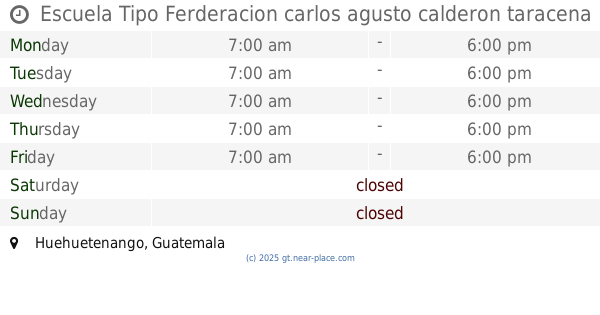
Escuela Tipo Ferderacion carlos agusto calderon taracena
Huehuetenango
School
read more
1.167 km
Escuela Tipo Federacion
Huehuetenango
School
read more
1.21 km
Cancha Sintética Los Encinos Zona 5
colonia los encinos
School
read more
1.374 km
Instituto Nacional de Educación Básica Experimental de Huehuetenango
Huehuetenango
School
read more
📑
all categories
Accounting
Administrative area level 1
Administrative area level 2
Airport
Amusement park
Aquarium
Art gallery
Atm
Bakery
Bank
Bar
Beauty salon
Bicycle store
Book store
Bowling alley
Bus station
Cafe
Campground
Car dealer
Car rental
Car repair
Car wash
Casino
Cemetery
Church
City hall
Clothing store
Colloquial area
Convenience store
Courthouse
Dentist
Department store
Doctor
Electrician
Electronics store
Embassy
Establishment
Finance
Fire station
Florist
Food
Funeral home
Furniture store
Gas station
General contractor
Grocery or supermarket
Gym
Hair care
Hardware store
Health
Hindu Temple
Home goods store
Hospital
Insurance agency
Jewelry store
Laundry
Lawyer
Library
Liquor store
Local government office
Locality
Locksmith
Lodging
Meal delivery
Meal takeaway
Mosque
Movie rental
Movie theater
Moving company
Museum
Natural feature
Neighborhood
Night club
Painter
Park
Parking
Pet store
Pharmacy
Physiotherapist
Place of worship
Plumber
Point of interest
Police
Political
Post office
Premise
Real estate agency
Restaurant
Route
Rv park, camping
School
Shoe store
Shopping mall
Spa
Stadium
Storage
Store
Subway station
Supermarket
Synagogue
Taxi stand
Train station
Transit station
Travel agency
University
Veterinary care
Zoo
administrative area level 3
sublocality level 1
↑