School nearby Liceo Mixto San Jose
Guatemala
School nearby Liceo Mixto San Jose
Liceo Mixto San Jose
Huehuetenango, Guatemala
contacts phone
:
+502 7769 0501
Latitude:
15.3184985
, Longitude:
-91.4856906
larger map & directions
read more
nearest School
179 m
Escuela Oficial Urbana Mixta Julio César Merida
1 calle, Zona 8, Huehuetenango
School
read more
351 m
mm more music
Huehuetenango
School
read more
395 m
Colegio Bilingüe Esperanza
Huehuetenango
School
read more
400 m
COLEGIO PRIVADO MIXTO EVANGÉLICO OASIS DE ENSEÑANZA MI-EL
Huehuetenango
School
read more
415 m
Idpp. Huehuetenango
Huehuetenango
School
read more
454 m
centro educativo tecnologico sion
Huehuetenango
School
read more
525 m
Colegio El Canadience
Zona 5, Huehuetenango
School
read more
537 m
IBEROAMERICANO
1-80, 1, 1 calle, Zona 8, Huehuetenango
School
read more
540 m
Colegio Liceo Canadiense Huehuetenango
Huehuetenango
School
read more
559 m
Complejo educativo Cambridge
Huehuetenango
School
read more
584 m
Liceo Dame
Huehuetenango
School
read more
660 m
Escuela Anexa Bienestar Social
Huehuetenango
School
read more
675 m
Colegio Preuniversitario Cambridge
Huehuetenango
School
read more
678 m
Soni.K
Huehuetenango
School
read more
685 m
Liceo Cristiano Mixto Palabra en Accion
Huehuetenango
School
read more
691 m
FUNDAL Huehuetenango
Huehuetenango
School
read more
693 m
Liceo Palabra en Acción
Huehuetenango
School
read more
755 m
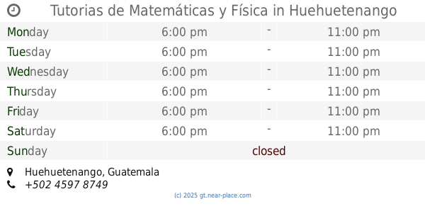
Tutorias de Matemáticas y Física
Huehuetenango
School
read more
783 m
Liceo mixto MANAVID
7a Calle, Huehuetenango
School
read more
796 m
Instituto Experimental
Huehuetenango
School
read more
819 m
Colegio San Lorenzo
Huehuetenango
School
read more
886 m
Dirección Departamental De Educación
Huehuetenango
School
read more
926 m
Colegio Rafael Landivar
Huehuetenango
School
read more
1.035 km
Escuela Oficial Puente Las Culebras II
Unnamed Road, Huehuetenango
School
read more
1.149 km
Spanish School Xinabajul
Unnamed Road, Huehuetenango
School
read more
📑
all categories
Accounting
Administrative area level 1
Administrative area level 2
Airport
Amusement park
Aquarium
Art gallery
Atm
Bakery
Bank
Bar
Beauty salon
Bicycle store
Book store
Bowling alley
Bus station
Cafe
Campground
Car dealer
Car rental
Car repair
Car wash
Casino
Cemetery
Church
City hall
Clothing store
Colloquial area
Convenience store
Courthouse
Dentist
Department store
Doctor
Electrician
Electronics store
Embassy
Establishment
Finance
Fire station
Florist
Food
Funeral home
Furniture store
Gas station
General contractor
Grocery or supermarket
Gym
Hair care
Hardware store
Health
Hindu Temple
Home goods store
Hospital
Insurance agency
Jewelry store
Laundry
Lawyer
Library
Liquor store
Local government office
Locality
Locksmith
Lodging
Meal delivery
Meal takeaway
Mosque
Movie rental
Movie theater
Moving company
Museum
Natural feature
Neighborhood
Night club
Painter
Park
Parking
Pet store
Pharmacy
Physiotherapist
Place of worship
Plumber
Point of interest
Police
Political
Post office
Premise
Real estate agency
Restaurant
Route
Rv park, camping
School
Shoe store
Shopping mall
Spa
Stadium
Storage
Store
Subway station
Supermarket
Synagogue
Taxi stand
Train station
Transit station
Travel agency
University
Veterinary care
Zoo
administrative area level 3
sublocality level 1
↑