Lodging nearby PENCIONADO CONFORT
Guatemala
Lodging nearby PENCIONADO CONFORT
PENCIONADO CONFORT
1 calle, Zona 8, Huehuetenango, Huehuetenango, GT Guatemala
contacts phone
:
+502 5593 3346
Latitude:
15.3194754
, Longitude:
-91.4834416
larger map & directions
read more
nearest Lodging
176 m
La Chacra de Joel Hotel
4a. Avenida 1-128, Huehuetenango
Lodging
read more
211 m
Hotel Los Laureles
Huehuetenango
Lodging
read more
321 m
Hotel los Lauleres
Huehuetenango
Lodging
read more
429 m
Hotel La Casona
Huehuetenango
Lodging
read more
456 m
Hotel Premier
Huehuetenango
Lodging
read more
681 m
Hotel La Cascada
9-275,, 4a Calle, Huehuetenango
Lodging
read more
693 m
Hotel El Portal De Los Cuchumatanes
Huehuetenango
Lodging
read more
832 m
HOTEL Casa Del Viajero
Calzada Kaibil Balam, Huehuetenango
Lodging
read more
850 m
Hotel Y Restaurante Plaza Florida
Calzada Kaibil Balam, Huehuetenango
Lodging
read more
851 m
Hotel del Prado
Huehuetenango
Lodging
read more
854 m
Hotel Cascata
Calzada Kaibil Balam, Huehuetenango
Lodging
read more
862 m
Hotel Dorado
6-70, 1 calle, Zona 8, Huehuetenango
Lodging
read more
876 m
Hotel Posada Tzolkin
Huehuetenango
Lodging
read more
885 m
Hotel Y Restaurante Kristal
Calzada Kaibil Balam, Huehuetenango
Lodging
read more
890 m
Hotel Grano del Paraíso
Huehuetenango
Lodging
read more
894 m
Hotel San Francisco
Calzada Kaibil Balam Zona 5 DE Huehuetenango, Guatemala
Lodging
read more
901 m
Hotel conquistador
Huehuetenango
Lodging
read more
926 m
Hotel Del Bosque
Huehuetenango
Lodging
read more
931 m
Hotel Ruinas Resort
Huehuetenango
Lodging
read more
941 m
Agencia Puente de Amistad Huehue
Calzada Kaibil Balam, Huehuetenango
Lodging
read more
945 m
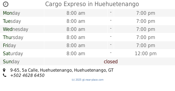
Cargo Expreso
5a Calle 9-65, Huehuetenango
Lodging
read more
1.002 km
Hotel Vasquez
Huehuetenango
Lodging
read more
1.052 km
Cementerio Corral Chiquito
10 Calle Final, Guatemala
Lodging
read more
1.165 km
Ixmucané
Huehuetenango
Lodging
read more
1.169 km
New Quality Hotel
Huehuetenango
Lodging
read more
📑
all categories
Accounting
Administrative area level 1
Administrative area level 2
Airport
Amusement park
Aquarium
Art gallery
Atm
Bakery
Bank
Bar
Beauty salon
Bicycle store
Book store
Bowling alley
Bus station
Cafe
Campground
Car dealer
Car rental
Car repair
Car wash
Casino
Cemetery
Church
City hall
Clothing store
Colloquial area
Convenience store
Courthouse
Dentist
Department store
Doctor
Electrician
Electronics store
Embassy
Establishment
Finance
Fire station
Florist
Food
Funeral home
Furniture store
Gas station
General contractor
Grocery or supermarket
Gym
Hair care
Hardware store
Health
Hindu Temple
Home goods store
Hospital
Insurance agency
Jewelry store
Laundry
Lawyer
Library
Liquor store
Local government office
Locality
Locksmith
Lodging
Meal delivery
Meal takeaway
Mosque
Movie rental
Movie theater
Moving company
Museum
Natural feature
Neighborhood
Night club
Painter
Park
Parking
Pet store
Pharmacy
Physiotherapist
Place of worship
Plumber
Point of interest
Police
Political
Post office
Premise
Real estate agency
Restaurant
Route
Rv park, camping
School
Shoe store
Shopping mall
Spa
Stadium
Storage
Store
Subway station
Supermarket
Synagogue
Taxi stand
Train station
Transit station
Travel agency
University
Veterinary care
Zoo
administrative area level 3
sublocality level 1
↑