Lodging nearby Hotel Posada Tzolkin
Guatemala
Lodging nearby Hotel Posada Tzolkin
Hotel Posada Tzolkin
Huehuetenango Guatemala
contacts phone
:
+502
Latitude:
15.3120609
, Longitude:
-91.4806739
read more
nearest Lodging
145 m
Hotel Y Restaurante Plaza Florida
Calzada Kaibil Balam, Huehuetenango
Lodging
read more
181 m
Hotel Del Bosque
Huehuetenango
Lodging
read more
187 m
Hotel Cascata
Calzada Kaibil Balam, Huehuetenango
Lodging
read more
195 m
Hotel El Portal De Los Cuchumatanes
Huehuetenango
Lodging
read more
299 m
Hotel Sinai
Huehuetenango
Lodging
read more
342 m
Hotel ]GUATEMEX
Huehuetenango
Lodging
read more
402 m
Hotel Dorado
6-70, 1 calle, Zona 8, Huehuetenango
Lodging
read more
471 m
Hotel Del Coronado, Huehuetenango
Unnamed Rd,, Huehuetenango
Lodging
read more
476 m
Hotel Balmoral
12 Av 10-83, Huehuetenango
Lodging
read more
480 m
Hotel Camino Real
Unnamed Road,, Huehuetenango
Lodging
read more
521 m
Hotel Grano del Paraíso
Huehuetenango
Lodging
read more
541 m
Hotel del Prado
Huehuetenango
Lodging
read more
545 m
Hotel conquistador
Huehuetenango
Lodging
read more
816 m
Hotel La Cascada
9-275,, 4a Calle, Huehuetenango
Lodging
read more
876 m
PENCIONADO CONFORT
1 calle, Zona 8, Huehuetenango
Lodging
read more
907 m
Hotel Vasquez
Huehuetenango
Lodging
read more
935 m
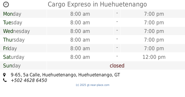
Cargo Expreso
5a Calle 9-65, Huehuetenango
Lodging
read more
940 m
Hotel Los Laureles
Huehuetenango
Lodging
read more
1.011 km
Hotel Casa Del Viajero
7-70 5, 9a. Avenida, Huehuetenango
Lodging
read more
1.111 km
Hotel Ruinas Resort
Huehuetenango
Lodging
read more
1.173 km
Hotel Los Angeles
Huehuetenango
Lodging
read more
1.266 km
Hotel Casa Blanca
7a Avenida, Huehuetenango
Lodging
read more
1.288 km
Posada Familiar
Huehuetenango
Lodging
read more
1.333 km
Hotel San Luis de La Sierra
Huehuetenango
Lodging
read more
1.361 km
Hotel Todos Santos Inn
Huehuetenango
Lodging
read more
📑
all categories
Accounting
Administrative area level 1
Administrative area level 2
Airport
Amusement park
Aquarium
Art gallery
Atm
Bakery
Bank
Bar
Beauty salon
Bicycle store
Book store
Bowling alley
Bus station
Cafe
Campground
Car dealer
Car rental
Car repair
Car wash
Casino
Cemetery
Church
City hall
Clothing store
Colloquial area
Convenience store
Courthouse
Dentist
Department store
Doctor
Electrician
Electronics store
Embassy
Establishment
Finance
Fire station
Florist
Food
Funeral home
Furniture store
Gas station
General contractor
Grocery or supermarket
Gym
Hair care
Hardware store
Health
Hindu Temple
Home goods store
Hospital
Insurance agency
Jewelry store
Laundry
Lawyer
Library
Liquor store
Local government office
Locality
Locksmith
Lodging
Meal delivery
Meal takeaway
Mosque
Movie rental
Movie theater
Moving company
Museum
Natural feature
Neighborhood
Night club
Painter
Park
Parking
Pet store
Pharmacy
Physiotherapist
Place of worship
Plumber
Point of interest
Police
Political
Post office
Premise
Real estate agency
Restaurant
Route
Rv park, camping
School
Shoe store
Shopping mall
Spa
Stadium
Storage
Store
Subway station
Supermarket
Synagogue
Taxi stand
Train station
Transit station
Travel agency
University
Veterinary care
Zoo
administrative area level 3
sublocality level 1
↑