Restaurant nearby Comedor Seguro
Guatemala
Restaurant nearby Comedor Seguro
Comedor Seguro
Guatemala
contacts phone
:
+502
Latitude:
14.5655154
, Longitude:
-89.9253233
larger map & directions
read more
nearest Restaurant
3.279 km
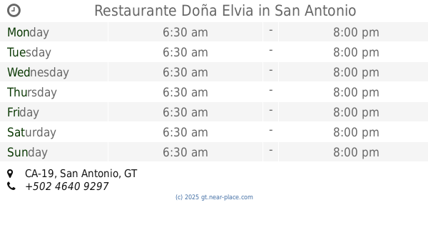
Restaurante Doña Elvia
CA-19, San Antonio
Restaurant
read more
3.882 km
Restaurante Mi Ranchito
San Antonio
Restaurant
read more
8.414 km
Restaurante El Asado
jalapa, frente al parque centenario, salida a, Monjas
Restaurant
read more
8.609 km
Shukos Y Churrascos
Guatemala
Restaurant
read more
8.883 km
Pupuseria y Refacciones Guisel
Monjas
Restaurant
read more
8.976 km
MI Restaurant
Monjas
Restaurant
read more
9.168 km
Monjattan Sports Bar & Grill
Monjas
Restaurant
read more
9.703 km
Pupuseria La Salvadoreña
Guatemala
Restaurant
read more
9.755 km
Restaurante Cattleya
4TA AV. 0-47, Z2. Entre tránsito Rojas y Primera calle., Jalapa
Restaurant
read more
9.801 km
Pupuseria Olocuilta
RN-18, Jalapa
Restaurant
read more
9.822 km
Linda vista Restaurante, Bar y Discoteca
Monjas
Restaurant
read more
9.864 km
La Pérgola Restaurante
3ra. calle final zona 5 barrio chipilapa
Restaurant
read more
9.871 km
China Princess
CA-19, Jalapa
Restaurant
read more
9.995 km
Royal Café
CA-19, Jalapa
Restaurant
read more
10.076 km
Restaurante El Sheick
2da. Avenida, Jalapa
Restaurant
read more
10.092 km
Fuente De Soda Bajo Cero Grados
Jalapa
Restaurant
read more
10.105 km
Comedor Dios Es Amor
Guatemala
Restaurant
read more
10.131 km
Pupuseria Olocuilta #2
mercado municipal
Restaurant
read more
10.207 km
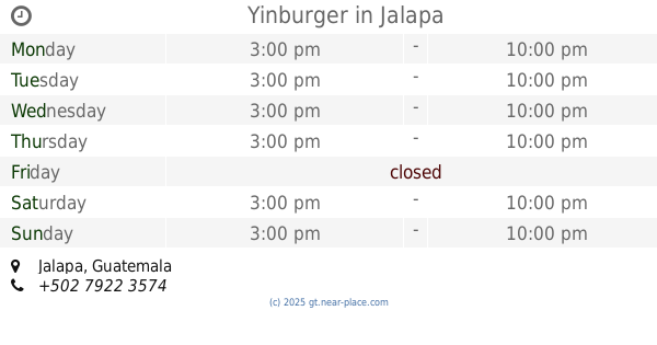
Yinburger
Jalapa
Restaurant
read more
10.287 km
Pupuseria SALVADOREÑA
Avenida Chipilapa, Barrio La Esperanza
Restaurant
read more
10.748 km
Azados "El Rey"
Unnamed Road
Restaurant
read more
10.861 km
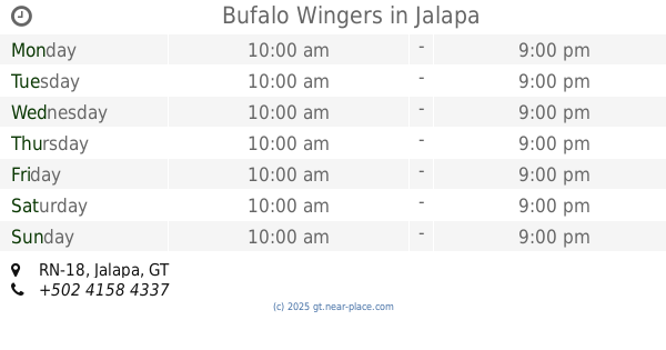
Bufalo Wingers
RN-18, Jalapa
Restaurant
read more
10.885 km
Casa Victoria
4-68 zona 2, Barrio san francisco, 7 Avenida, Jalapa
Restaurant
read more
12.906 km
Antojitos Los Charros
aldea el pinalito, San Pedro Pinula
Restaurant
read more
13.92 km
Comedor "ELY"
San Pedro Pinula
Restaurant
read more
📑
all categories
Accounting
Administrative area level 1
Administrative area level 2
Airport
Amusement park
Aquarium
Art gallery
Atm
Bakery
Bank
Bar
Beauty salon
Bicycle store
Book store
Bowling alley
Bus station
Cafe
Campground
Car dealer
Car rental
Car repair
Car wash
Casino
Cemetery
Church
City hall
Clothing store
Colloquial area
Convenience store
Courthouse
Dentist
Department store
Doctor
Electrician
Electronics store
Embassy
Establishment
Finance
Fire station
Florist
Food
Funeral home
Furniture store
Gas station
General contractor
Grocery or supermarket
Gym
Hair care
Hardware store
Health
Hindu Temple
Home goods store
Hospital
Insurance agency
Jewelry store
Laundry
Lawyer
Library
Liquor store
Local government office
Locality
Locksmith
Lodging
Meal delivery
Meal takeaway
Mosque
Movie rental
Movie theater
Moving company
Museum
Natural feature
Neighborhood
Night club
Painter
Park
Parking
Pet store
Pharmacy
Physiotherapist
Place of worship
Plumber
Point of interest
Police
Political
Post office
Premise
Real estate agency
Restaurant
Route
Rv park, camping
School
Shoe store
Shopping mall
Spa
Stadium
Storage
Store
Subway station
Supermarket
Synagogue
Taxi stand
Train station
Transit station
Travel agency
University
Veterinary care
Zoo
administrative area level 3
sublocality level 1
↑