Restaurant nearby Comedor Dios Es Amor
Guatemala
Restaurant nearby Comedor Dios Es Amor
Comedor Dios Es Amor
Guatemala Gwatemala
contacts phone
:
+502
Latitude:
14.6336889
, Longitude:
-89.9874332
read more
nearest Restaurant
37 m
Pupuseria Olocuilta #2
mercado municipal
Restaurant
read more
114 m
Royal Café
CA-19, Jalapa
Restaurant
read more
134 m
Antojitos Acuario
Jalapa
Restaurant
read more
184 m
Panderia la excelencia
Jalapa
Restaurant
read more
223 m
Restaurante Pollo Campero
Jalapa
Restaurant
read more
249 m
La Pérgola Restaurante
3ra. calle final zona 5 barrio chipilapa
Restaurant
read more
269 m
China Princess
CA-19, Jalapa
Restaurant
read more
274 m
Rapicomidas Menorah
Jalapa
Restaurant
read more
284 m
Restaurante El Sheick
2da. Avenida, Jalapa
Restaurant
read more
293 m
Guateburger Jalapa
Jalapa
Restaurant
read more
304 m
Pupuseria SALVADOREÑA
Avenida Chipilapa, Barrio La Esperanza
Restaurant
read more
338 m
Chino Pekin
Jalapa
Restaurant
read more
349 m
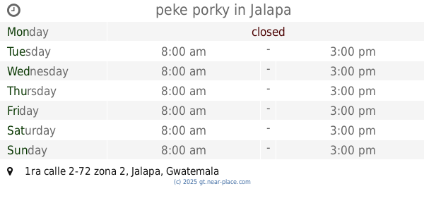
peke porky
1ra calle 2-72 zona 2, Jalapa
Restaurant
read more
389 m
Pupuseria Olocuilta
RN-18, Jalapa
Restaurant
read more
418 m
Pupuseria La Salvadoreña
Guatemala
Restaurant
read more
438 m
Restaurante Parrillada Argentina La Pampa
Jalapa
Restaurant
read more
449 m
Fuente De Soda Bajo Cero Grados
Jalapa
Restaurant
read more
568 m
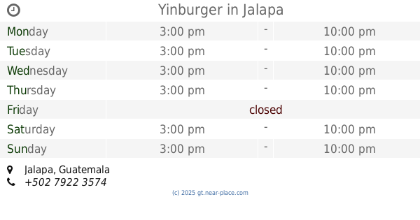
Yinburger
Jalapa
Restaurant
read more
582 m
Restaurante Cattleya
4TA AV. 0-47, Z2. Entre tránsito Rojas y Primera calle., Jalapa
Restaurant
read more
592 m
Guacamole
4ta. Avenida 0-46 Zona 1
Restaurant
read more
667 m
Chicharronera "El Cebollon"
Jalapa
Restaurant
read more
734 m
Restaurante El Alboroto
Jalapa
Restaurant
read more
809 m
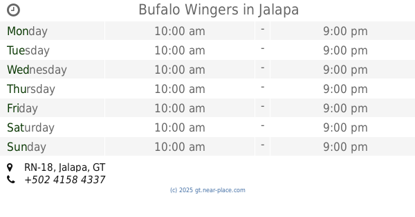
Bufalo Wingers
RN-18, Jalapa
Restaurant
read more
993 m
Casa Victoria
4-68 zona 2, Barrio san francisco, 7 Avenida, Jalapa
Restaurant
read more
1.007 km
CAFE & Cultura
4ta Avenida zona 1 Barrio La Democracia Jalapa
Restaurant
read more
📑
all categories
Accounting
Administrative area level 1
Administrative area level 2
Airport
Amusement park
Aquarium
Art gallery
Atm
Bakery
Bank
Bar
Beauty salon
Bicycle store
Book store
Bowling alley
Bus station
Cafe
Campground
Car dealer
Car rental
Car repair
Car wash
Casino
Cemetery
Church
City hall
Clothing store
Colloquial area
Convenience store
Courthouse
Dentist
Department store
Doctor
Electrician
Electronics store
Embassy
Establishment
Finance
Fire station
Florist
Food
Funeral home
Furniture store
Gas station
General contractor
Grocery or supermarket
Gym
Hair care
Hardware store
Health
Hindu Temple
Home goods store
Hospital
Insurance agency
Jewelry store
Laundry
Lawyer
Library
Liquor store
Local government office
Locality
Locksmith
Lodging
Meal delivery
Meal takeaway
Mosque
Movie rental
Movie theater
Moving company
Museum
Natural feature
Neighborhood
Night club
Painter
Park
Parking
Pet store
Pharmacy
Physiotherapist
Place of worship
Plumber
Point of interest
Police
Political
Post office
Premise
Real estate agency
Restaurant
Route
Rv park, camping
School
Shoe store
Shopping mall
Spa
Stadium
Storage
Store
Subway station
Supermarket
Synagogue
Taxi stand
Train station
Transit station
Travel agency
University
Veterinary care
Zoo
administrative area level 3
sublocality level 1
↑