Lodging nearby Posada La Ermita
Guatemala
Lodging nearby Posada La Ermita
Posada La Ermita
Cobán Guatemala
contacts phone
:
+502
Latitude:
15.4890711
, Longitude:
-90.3662633
read more
nearest Lodging
771 m
Chajxucub
Cobán
Lodging
read more
1.15 km
Hotel Gran Torre
3 Avenida 7-44, Zona 11, Cobán
Lodging
read more
1.15 km
Big Tower Hotel
3 Avenida 7-44, Zona 11, Cobán
Lodging
read more
1.212 km
Hotel posada La Ermita
Cobán
Lodging
read more
1.292 km
Hotel y Restaurante Casa Gaia
Cobán
Lodging
read more
1.622 km
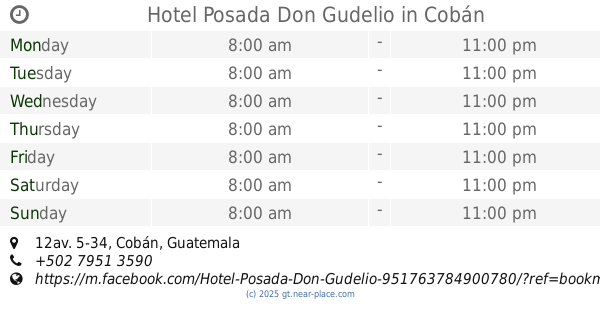
Hotel Posada Don Gudelio
12av. 5-34, Cobán
Lodging
read more
1.664 km
Hotel ALCAZAR DOÑA VICTORIA
1a Avenida, Cobán
Lodging
read more
1.797 km
Ischa
Cobán
Lodging
read more
1.835 km
Hotel El Ecologico
4a Avenida, Cobán
Lodging
read more
1.835 km
Posada de Carlos V
Cobán
Lodging
read more
1.891 km
zapateria DonCarlos
6a Avenida, Cobán
Lodging
read more
1.896 km
Hospedaje Elsita
Cobán
Lodging
read more
1.925 km
Hotel La Colonia
Cobán
Lodging
read more
1.967 km
Hotel Villa Imelda
4a Avenida 2-21, Cobán
Lodging
read more
1.98 km
Hotel Casa Piedra Luna
7a avenida 1-25, Cobán
Lodging
read more
2.08 km
Hotel Don Juan Matalbatz
3A Calle 1-46, Cobán
Lodging
read more
2.102 km
Hotel Villa Ancestral
3A Calle, Cobán
Lodging
read more
2.184 km
Hotel Los Faroles de Cobán
Cobán
Lodging
read more
2.209 km
Hostal Casa Tenango
2da calle, entre 3ra y 5ta avenida, zona1, Cobán
Lodging
read more
2.232 km
Hostal Casa Luna
5a Avenida, Cobán
Lodging
read more
2.255 km
Hotel Cacao Coban
7a Avenida, Cobán
Lodging
read more
2.262 km
Hotel La Paz
Cobán
Lodging
read more
2.265 km
Hotel Mansion Armenia
Cobán
Lodging
read more
2.36 km
Hostal el calvario
2a Calle, Cobán
Lodging
read more
2.705 km
Hotel Donde Tancho
Cobán
Lodging
read more
📑
all categories
Accounting
Administrative area level 1
Administrative area level 2
Airport
Amusement park
Aquarium
Art gallery
Atm
Bakery
Bank
Bar
Beauty salon
Bicycle store
Book store
Bowling alley
Bus station
Cafe
Campground
Car dealer
Car rental
Car repair
Car wash
Casino
Cemetery
Church
City hall
Clothing store
Colloquial area
Convenience store
Courthouse
Dentist
Department store
Doctor
Electrician
Electronics store
Embassy
Establishment
Finance
Fire station
Florist
Food
Funeral home
Furniture store
Gas station
General contractor
Grocery or supermarket
Gym
Hair care
Hardware store
Health
Hindu Temple
Home goods store
Hospital
Insurance agency
Jewelry store
Laundry
Lawyer
Library
Liquor store
Local government office
Locality
Locksmith
Lodging
Meal delivery
Meal takeaway
Mosque
Movie rental
Movie theater
Moving company
Museum
Natural feature
Neighborhood
Night club
Painter
Park
Parking
Pet store
Pharmacy
Physiotherapist
Place of worship
Plumber
Point of interest
Police
Political
Post office
Premise
Real estate agency
Restaurant
Route
Rv park, camping
School
Shoe store
Shopping mall
Spa
Stadium
Storage
Store
Subway station
Supermarket
Synagogue
Taxi stand
Train station
Transit station
Travel agency
University
Veterinary care
Zoo
administrative area level 3
sublocality level 1
↑