Lodging nearby Hotel La Colonia
Guatemala
Lodging nearby Hotel La Colonia
Hotel La Colonia
Cobán, Guatemala
contacts phone
:
+502 7951 4029
Latitude:
15.4718582
, Longitude:
-90.3643637
larger map & directions
read more
nearest Lodging
414 m
Hotel Casa Piedra Luna
7a avenida 1-25, Cobán
Lodging
read more
456 m
Casa Serena
Cobán
Lodging
read more
490 m
zapateria DonCarlos
6a Avenida, Cobán
Lodging
read more
494 m
Hotel María Andre
entre y A.V.,, 2a Calle, Cobán
Lodging
read more
494 m
Hotel María Andre
entre y A.V.,, 2a Calle & 6a Avenida, Cobán
Lodging
read more
497 m
Hotel en Coban Casa Qeqchi
4ta calle 7-29 zona 3, Cobán
Lodging
read more
559 m
Posada de Don Antonio
5a Avenida 1-51, Cobán
Lodging
read more
559 m
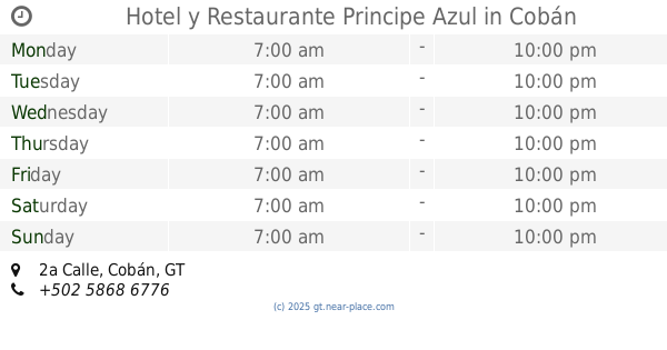
Hotel y Restaurante Principe Azul
2a Calle, Cobán
Lodging
read more
564 m
Hotel Posada De Coban
5a Avenida, Cobán
Lodging
read more
592 m
Hotel Villa Imelda
4a Avenida 2-21, Cobán
Lodging
read more
600 m
D'Tano Hotel
2da avenida 3-45 zona 3, Cobán
Lodging
read more
614 m
Hotel El Ecologico
4a Avenida, Cobán
Lodging
read more
634 m
Hotel y Restaurante Casa Gaia
Cobán
Lodging
read more
673 m
Casa Duranta
3A Calle 4-46, Cobán
Lodging
read more
844 m
Hostal Del Angel
Cobán
Lodging
read more
857 m
Hotel Central
1a Calle 1-79, Cobán
Lodging
read more
861 m
DON EDILIO
Cobán
Lodging
read more
870 m
Hotel posada La Ermita
Cobán
Lodging
read more
877 m
Big Tower Hotel
3 Avenida 7-44, Zona 11, Cobán
Lodging
read more
889 m
Hotel Sagrado Corazon De Jesus
Cobán
Lodging
read more
895 m
Posada de Carlos V
Cobán
Lodging
read more
934 m
Hotel Virgen Del Rosario
Cobán
Lodging
read more
965 m
Ischa
Cobán
Lodging
read more
977 m
Hotel Don Juan Matalbatz
3A Calle 1-46, Cobán
Lodging
read more
1.045 km
Hotel El Paraiso
Residenciales Imperial, Cobán
Lodging
read more
📑
all categories
Accounting
Administrative area level 1
Administrative area level 2
Airport
Amusement park
Aquarium
Art gallery
Atm
Bakery
Bank
Bar
Beauty salon
Bicycle store
Book store
Bowling alley
Bus station
Cafe
Campground
Car dealer
Car rental
Car repair
Car wash
Casino
Cemetery
Church
City hall
Clothing store
Colloquial area
Convenience store
Courthouse
Dentist
Department store
Doctor
Electrician
Electronics store
Embassy
Establishment
Finance
Fire station
Florist
Food
Funeral home
Furniture store
Gas station
General contractor
Grocery or supermarket
Gym
Hair care
Hardware store
Health
Hindu Temple
Home goods store
Hospital
Insurance agency
Jewelry store
Laundry
Lawyer
Library
Liquor store
Local government office
Locality
Locksmith
Lodging
Meal delivery
Meal takeaway
Mosque
Movie rental
Movie theater
Moving company
Museum
Natural feature
Neighborhood
Night club
Painter
Park
Parking
Pet store
Pharmacy
Physiotherapist
Place of worship
Plumber
Point of interest
Police
Political
Post office
Premise
Real estate agency
Restaurant
Route
Rv park, camping
School
Shoe store
Shopping mall
Spa
Stadium
Storage
Store
Subway station
Supermarket
Synagogue
Taxi stand
Train station
Transit station
Travel agency
University
Veterinary care
Zoo
administrative area level 3
sublocality level 1
↑