Food nearby Librería Pelonsky
Coronavirus disease (COVID-19) Situation
confirmed cases
1291293
deaths
20289
Guatemala
Food nearby Librería Pelonsky
Librería Pelonsky
12 Avenida, Zacapa, GT Guatemala
contacts phone
:
+502
Latitude:
14.9714878
, Longitude:
-89.531718
larger map & directions
read more
nearest Food
297 m
Pizza Burger Diner Zacapa,Zacapa
Zacapa
Food
read more
301 m
Multiservicios MG
Zacapa
Food
read more
532 m
Tamales Chocoj
Zacapa
Food
read more
1.13 km
Distribuidora MAC
8va Calle 2-20 Zona 2
Food
read more
4.008 km
Duwest Estanzuela
Estanzuela
Food
read more
18.236 km
PIZZA BURGER DINER PRADERA
CA-10, Chiquimula
Food
read more
18.241 km
Energuate Shoropin
Calzada Héctor Agusto España Bracamonte, Chiquimula
Food
read more
18.32 km
Bodega De Don Alejandro
Barrio Sasmó Abajo
Food
read more
18.391 km
Fabrica De Alimentos Y Conservas La Perfecta
Chiquimula
Food
read more
19.04 km
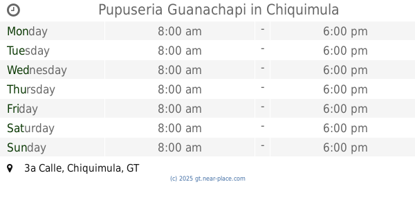
Pupuseria Guanachapi
3a Calle, Chiquimula
Food
read more
19.059 km
Ambev Centroamérica
Teculután
Food
read more
19.087 km
Comedores Mercado Municipal
8a Avenida, Chiquimula
Food
read more
19.131 km
Distribuidora La Ceiba, S.A.
15a. Avenida, Chiquimula
Food
read more
19.255 km
Guater Pura
5a Calle, Chiquimula
Food
read more
19.786 km
Rastro Municipal de Chiquimula
Chiquimula
Food
read more
19.989 km
Bodega Teculutan, Zacapa (Centia)
Teculután
Food
read more
20.113 km
Coguma
Kilómetro 121.5 Carretera al Atlántico Centro Empresarial Tecolotlán, Bodega No. 1, Carretera Jacobo Árbenz Guzmán, Teculután
Food
read more
20.812 km
Pilonera Copropiedad
Guatemala
Food
read more
22.494 km
Carnicería Porky
Jocotan
Food
read more
22.692 km
La Bodeguita
Jocotan
Food
read more
38.776 km
Antojitos Chavi
3 av. 3-55 zona 2, RN-18 3-55, Quezaltepeque
Food
read more
40.271 km
Panaderia el Esfuerzo
Ipala
Food
read more
49.938 km
Agua Pura "Los Pinos"
Colonia San Jose Obrero, Esquipulas
Food
read more
61.624 km
Comercial De Leon
Jalapa
Food
read more
📑
all categories
Accounting
Administrative area level 1
Administrative area level 2
Airport
Amusement park
Aquarium
Art gallery
Atm
Bakery
Bank
Bar
Beauty salon
Bicycle store
Book store
Bowling alley
Bus station
Cafe
Campground
Car dealer
Car rental
Car repair
Car wash
Casino
Cemetery
Church
City hall
Clothing store
Colloquial area
Convenience store
Courthouse
Dentist
Department store
Doctor
Electrician
Electronics store
Embassy
Establishment
Finance
Fire station
Florist
Food
Funeral home
Furniture store
Gas station
General contractor
Grocery or supermarket
Gym
Hair care
Hardware store
Health
Hindu Temple
Home goods store
Hospital
Insurance agency
Jewelry store
Laundry
Lawyer
Library
Liquor store
Local government office
Locality
Locksmith
Lodging
Meal delivery
Meal takeaway
Mosque
Movie rental
Movie theater
Moving company
Museum
Natural feature
Neighborhood
Night club
Painter
Park
Parking
Pet store
Pharmacy
Physiotherapist
Place of worship
Plumber
Point of interest
Police
Political
Post office
Premise
Real estate agency
Restaurant
Route
Rv park, camping
School
Shoe store
Shopping mall
Spa
Stadium
Storage
Store
Subway station
Supermarket
Synagogue
Taxi stand
Train station
Transit station
Travel agency
University
Veterinary care
Zoo
administrative area level 3
sublocality level 1
↑