Food nearby Comedor Seguro
Coronavirus disease (COVID-19) Situation
confirmed cases
1291293
deaths
20289
Guatemala
Food nearby Comedor Seguro
Comedor Seguro
Guatemala
contacts phone
:
+502
Latitude:
14.5655154
, Longitude:
-89.9253233
larger map & directions
read more
nearest Food
9.023 km
El Pinal Specialty Coffee
Monjas
Food
read more
9.519 km
Comercial De Leon
Jalapa
Food
read more
9.766 km
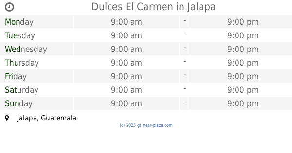
Dulces El Carmen
Jalapa
Food
read more
9.909 km
Pizza Burger Diner Jalapa
RN-18, Jalapa
Food
read more
10.412 km
Piñatería Gran Fiesta
4a. Av. 2-25 zona 2 Barrio San Francisco, Jalapa
Food
read more
10.56 km
Restaurante Jeremy's Pizza
2da avenida, Jalapa
Food
read more
12.534 km
Granja Carrera
Unnamed Road
Food
read more
24.377 km
Veneficio De Cafe
Guatemala
Food
read more
24.643 km
Pizza Burger Diner Jutiapa
4th Street, 2nd Zone, El Progreso
Food
read more
24.72 km
Candy paradise
2a Calle, Zona 2, El Progreso
Food
read more
29.309 km
Bodega de Azucar Jutiapa
Jutiapa
Food
read more
31.466 km
Agencia Pepsi
Food
read more
31.66 km
CEM
Unnamed Road
Food
read more
32.157 km
El Veneficio De Cafe
Guatemala
Food
read more
33.304 km
Panaderia el Esfuerzo
Ipala
Food
read more
34.207 km
Alquifiestas La Elegancia
Asunción Mita
Food
read more
35.6 km
Agro química Guastatoya
Guastatoya
Food
read more
41.669 km
Finca La Bendicion
Palencia
Food
read more
43.504 km
Agua Fresh
Yupiltepeque
Food
read more
47.581 km
Guater Pura
5a Calle, Chiquimula
Food
read more
49.729 km
Energuate Shoropin
Calzada Héctor Agusto España Bracamonte, Chiquimula
Food
read more
51.717 km
La Barata
Cuilapa
Food
read more
53.171 km
Ambev Centroamérica
Teculután
Food
read more
55.701 km
Alquifiestas Acuario
km 5, Carretera a El Salvador 53
Food
read more
60.96 km
Distribuidora MAC
8va Calle 2-20 Zona 2
Food
read more
📑
all categories
Accounting
Administrative area level 1
Administrative area level 2
Airport
Amusement park
Aquarium
Art gallery
Atm
Bakery
Bank
Bar
Beauty salon
Bicycle store
Book store
Bowling alley
Bus station
Cafe
Campground
Car dealer
Car rental
Car repair
Car wash
Casino
Cemetery
Church
City hall
Clothing store
Colloquial area
Convenience store
Courthouse
Dentist
Department store
Doctor
Electrician
Electronics store
Embassy
Establishment
Finance
Fire station
Florist
Food
Funeral home
Furniture store
Gas station
General contractor
Grocery or supermarket
Gym
Hair care
Hardware store
Health
Hindu Temple
Home goods store
Hospital
Insurance agency
Jewelry store
Laundry
Lawyer
Library
Liquor store
Local government office
Locality
Locksmith
Lodging
Meal delivery
Meal takeaway
Mosque
Movie rental
Movie theater
Moving company
Museum
Natural feature
Neighborhood
Night club
Painter
Park
Parking
Pet store
Pharmacy
Physiotherapist
Place of worship
Plumber
Point of interest
Police
Political
Post office
Premise
Real estate agency
Restaurant
Route
Rv park, camping
School
Shoe store
Shopping mall
Spa
Stadium
Storage
Store
Subway station
Supermarket
Synagogue
Taxi stand
Train station
Transit station
Travel agency
University
Veterinary care
Zoo
administrative area level 3
sublocality level 1
↑