School nearby San José Carrizal, Jalapa.
Guatemala
School nearby San José Carrizal, Jalapa.
San José Carrizal, Jalapa.
Guatemala Guatemala
contacts phone
:
+502
Latitude:
14.6783772
, Longitude:
-90.1265107
read more
nearest School
4.162 km
Escuela Oficial Rural Mixta Caserio Lagunilla
Guatemala
School
read more
5.146 km
Campo Sanyuyo
Guatemala
School
read more
7.47 km
Supervision Educativa
Sansare
School
read more
7.829 km
Escuela el morrito
Guatemala
School
read more
8.054 km
Escuela el centro
Guatemala
School
read more
8.919 km
Escuela Raymundo Marroquin Hernández
Aldea Los Ceritos, Sansare
School
read more
8.98 km
Libreria
Aldea Los Ceritos, Sansare
School
read more
9.442 km
Caserio Los Cruces; Santa Maria Xapalan, Jalapa
Guatemala
School
read more
10.165 km
Los Magueyes, San Antonio Las Flores, Jalapa
Los Magueyes, Las Flores, CA., San Antonio
School
read more
12.255 km
Aldea El Bosque
Guatemala
School
read more
13.776 km
ESTECA-PC
Sanarate
School
read more
14.045 km
INEB Guastatoya
Unnamed Rd, Sanarate
School
read more
14.35 km
Escuela El Porvenir
Jalapa
School
read more
14.404 km
Academia
Academia SP
School
read more
14.406 km
Acaemia de Computación San Pablo
Colonia Chinchilla
School
read more
14.546 km
Colegio Guatemalam
Sanarate
School
read more
14.938 km
INEB Telesecundaria
Aldea Pino Dulce, Mataquescuintla
School
read more
15.061 km
Instituto Nacional Experimental Silvano Antonio Carias Recinos
Jalapa
School
read more
15.288 km
El Desmonte
El Desmonte, Mataquescuintla
School
read more
15.396 km
Instituto Normal Centro Americano Para Varones (INCAV)
Jalapa
School
read more
15.403 km
INEB-INCAV JALAPA
Jalapa
School
read more
15.513 km
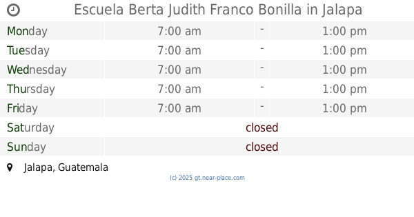
Escuela para niñas "Berta Judith Franco Bonilla"
Jalapa
School
read more
15.525 km
Escuela Berta Judith Franco Bonilla
Jalapa
School
read more
15.551 km
Centro Profesional de Cómputo
Guatemala
School
read more
18.903 km
Escuela Oficial Rural Mixta "Parvulos"
El Conacaste
School
read more
📑
all categories
Accounting
Administrative area level 1
Administrative area level 2
Airport
Amusement park
Aquarium
Art gallery
Atm
Bakery
Bank
Bar
Beauty salon
Bicycle store
Book store
Bowling alley
Bus station
Cafe
Campground
Car dealer
Car rental
Car repair
Car wash
Casino
Cemetery
Church
City hall
Clothing store
Colloquial area
Convenience store
Courthouse
Dentist
Department store
Doctor
Electrician
Electronics store
Embassy
Establishment
Finance
Fire station
Florist
Food
Funeral home
Furniture store
Gas station
General contractor
Grocery or supermarket
Gym
Hair care
Hardware store
Health
Hindu Temple
Home goods store
Hospital
Insurance agency
Jewelry store
Laundry
Lawyer
Library
Liquor store
Local government office
Locality
Locksmith
Lodging
Meal delivery
Meal takeaway
Mosque
Movie rental
Movie theater
Moving company
Museum
Natural feature
Neighborhood
Night club
Painter
Park
Parking
Pet store
Pharmacy
Physiotherapist
Place of worship
Plumber
Point of interest
Police
Political
Post office
Premise
Real estate agency
Restaurant
Route
Rv park, camping
School
Shoe store
Shopping mall
Spa
Stadium
Storage
Store
Subway station
Supermarket
Synagogue
Taxi stand
Train station
Transit station
Travel agency
University
Veterinary care
Zoo
administrative area level 3
sublocality level 1
↑