School nearby Escuela Santo Tomas
Guatemala
School nearby Escuela Santo Tomas
Escuela Santo Tomas
Cobán, Guatemala
contacts phone
:
+502
Latitude:
15.4771738
, Longitude:
-90.37143
larger map & directions
read more
nearest School
221 m
Instituto Nornal Mixto Del Norte Emilio Rosales Ponce
Cobán
School
read more
416 m
Liceo Preuniversitario del Norte
3a. Avenida 8-32 zona 10, Barrio La Libertad, 3, Cobán
School
read more
497 m
En Mi Casita XD
el maestro, Cobán
School
read more
500 m
Colegio Nazareno
Cobán
School
read more
585 m
Escuela De Enfermeria
6a Avenida, Cobán
School
read more
593 m
Casa Del Deportista Cobán
Cobán
School
read more
674 m
EODP 'FEDERICO FROEBEL'
3A AVE. 2-35 ZONA 1, 3a Avenida 3A, Cobán
School
read more
685 m
Teodoro Alberto Pérez Duering
10-21,, 2a Calle, Cobán
School
read more
686 m
Colegio Antos de Montesinos
Cobán
School
read more
692 m
IGER -Cobán
5a Calle 9-56 Zona 4
School
read more
781 m
Colegio Centro Educativo Guatemalteco
Cobán
School
read more
811 m
Ica Colegio Bilingüe
2a Avenida, Cobán
School
read more
813 m
Liceo Tecnico Cristiano NUEVA JUVENTUD
Cobán
School
read more
832 m
Active Spanish School
Cobán
School
read more
846 m
URG SEDE COBAN
Cobán
School
read more
863 m
COLEGIO BILINGUE DE INFANTES
8-50,, 1a Calle, Cobán
School
read more
883 m
Escuela La Libertad
Cobán
School
read more
883 m
School La Libertad
Cobán
School
read more
895 m
Anexo Departamental de Educacion
3-40 de la A.V., 3A Calle, Cobán
School
read more
903 m
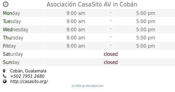
Asociación CasaSito AV
Cobán
School
read more
915 m
Colegio Nuevos Senderos
3A Calle, Cobán
School
read more
928 m
Colegio STEPS
Cobán
School
read more
1.01 km
INSTITUO Y ACADEMIA MARIC
Cobán
School
read more
1.036 km
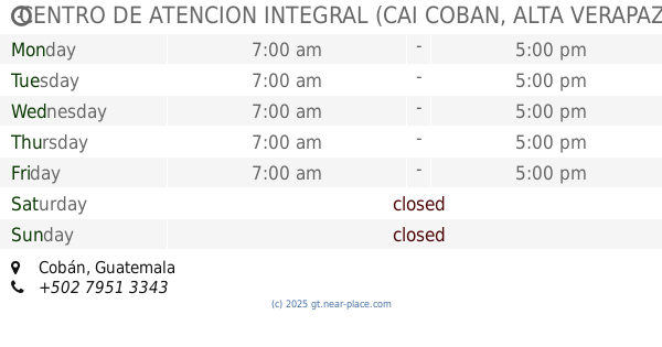
CENTRO DE ATENCION INTEGRAL (CAI COBAN, ALTA VERAPAZ).
Cobán
School
read more
1.158 km
Centro Integral Profesional En Computacion
2-10, 2a Calle, Cobán
School
read more
📑
all categories
Accounting
Administrative area level 1
Administrative area level 2
Airport
Amusement park
Aquarium
Art gallery
Atm
Bakery
Bank
Bar
Beauty salon
Bicycle store
Book store
Bowling alley
Bus station
Cafe
Campground
Car dealer
Car rental
Car repair
Car wash
Casino
Cemetery
Church
City hall
Clothing store
Colloquial area
Convenience store
Courthouse
Dentist
Department store
Doctor
Electrician
Electronics store
Embassy
Establishment
Finance
Fire station
Florist
Food
Funeral home
Furniture store
Gas station
General contractor
Grocery or supermarket
Gym
Hair care
Hardware store
Health
Hindu Temple
Home goods store
Hospital
Insurance agency
Jewelry store
Laundry
Lawyer
Library
Liquor store
Local government office
Locality
Locksmith
Lodging
Meal delivery
Meal takeaway
Mosque
Movie rental
Movie theater
Moving company
Museum
Natural feature
Neighborhood
Night club
Painter
Park
Parking
Pet store
Pharmacy
Physiotherapist
Place of worship
Plumber
Point of interest
Police
Political
Post office
Premise
Real estate agency
Restaurant
Route
Rv park, camping
School
Shoe store
Shopping mall
Spa
Stadium
Storage
Store
Subway station
Supermarket
Synagogue
Taxi stand
Train station
Transit station
Travel agency
University
Veterinary care
Zoo
administrative area level 3
sublocality level 1
↑