School nearby Colegio Evangélico Trilingue Preuniversitario de Occidente
Guatemala
School nearby Colegio Evangélico Trilingue Preuniversitario de Occidente
Colegio Evangélico Trilingue Preuniversitario de Occidente
Totonicapán Guatemala
contacts phone
:
+502
Latitude:
14.8640838
, Longitude:
-91.3869515
read more
nearest School
861 m
EORM JV aldea Vásquez
Guatemala
School
read more
925 m
Colegio Mi Gran Tesoro
Totonicapán
School
read more
1.022 km
SOSEP
Totonicapán
School
read more
1.234 km
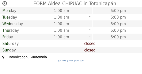
EORM Aldea CHIPUAC
Totonicapán
School
read more
2.565 km
Paraje Xequiac
paraje Xequiac
School
read more
2.701 km
EORM Adrian Inez Chaves
Cantón Xolsacmaljá
School
read more
3.344 km
EORM ALDEA NIMASAC
TZANNIMASAC
School
read more
3.399 km
IBC Xepopabaj
Ramón San, San Cristóbal Totonicapán
School
read more
3.596 km
Rafael Alvares Ovalle
Chuculjuyup
School
read more
3.633 km
Colegio Esmirna
Totonicapán
School
read more
3.658 km
Instituto de Educación Básica por Cooperativa
Aldea, Chuculjuyup
School
read more
3.988 km
I.B.C.
Totonicapán
School
read more
4.038 km
Sport CENTER
Aldea Chuatroj, Totonicapán
School
read more
4.573 km
EORM Cantón San Ramón
Totonicapán
School
read more
4.798 km
Jose Cruz Pacheco Tahay
Chuicruz
School
read more
4.875 km
Instituto "Educación Para La Vida"
iglesia PALABRA MIEL TOTONICAPAN. Paraje Pujacar, Camino hacia, Cantón Xantún, Totonicapán
School
read more
4.948 km
Escuela Chi-Batz
Totonicapán
School
read more
4.967 km
Escuela Justo Rufino Barrios
Totonicapán
School
read more
5.588 km
ITCT
Totonicapán
School
read more
5.645 km
Escuela
Quetzatango, Quezaltenango
School
read more
5.714 km
Centro de Estudios Avanzados -CEA-
9a. 08-043 3,, Avenida "A", Quezaltenango
School
read more
6.05 km
E.O.R.M PARAJE XEUL
Unnamed Road
School
read more
6.072 km
Pachipac Nahuala Solola
Nahualá
School
read more
6.953 km
Escuela Oficial Mixta La Estancia Cantel
Iglesia Catolica de La Estancia Cante, Cantel
School
read more
8.484 km
intituto de educasion Basica
San Cristóbal Totonicapán
School
read more
📑
all categories
Accounting
Administrative area level 1
Administrative area level 2
Airport
Amusement park
Aquarium
Art gallery
Atm
Bakery
Bank
Bar
Beauty salon
Bicycle store
Book store
Bowling alley
Bus station
Cafe
Campground
Car dealer
Car rental
Car repair
Car wash
Casino
Cemetery
Church
City hall
Clothing store
Colloquial area
Convenience store
Courthouse
Dentist
Department store
Doctor
Electrician
Electronics store
Embassy
Establishment
Finance
Fire station
Florist
Food
Funeral home
Furniture store
Gas station
General contractor
Grocery or supermarket
Gym
Hair care
Hardware store
Health
Hindu Temple
Home goods store
Hospital
Insurance agency
Jewelry store
Laundry
Lawyer
Library
Liquor store
Local government office
Locality
Locksmith
Lodging
Meal delivery
Meal takeaway
Mosque
Movie rental
Movie theater
Moving company
Museum
Natural feature
Neighborhood
Night club
Painter
Park
Parking
Pet store
Pharmacy
Physiotherapist
Place of worship
Plumber
Point of interest
Police
Political
Post office
Premise
Real estate agency
Restaurant
Route
Rv park, camping
School
Shoe store
Shopping mall
Spa
Stadium
Storage
Store
Subway station
Supermarket
Synagogue
Taxi stand
Train station
Transit station
Travel agency
University
Veterinary care
Zoo
administrative area level 3
sublocality level 1
↑