School nearby Colegio Country Kids
Guatemala
School nearby Colegio Country Kids
Colegio Country Kids
Sector B2 Guatemala
contacts phone
:
+502
Latitude:
14.6016001
, Longitude:
-90.5823714
read more
nearest School
110 m
Colegio Español Americano
Sector B2, Guatemala
School
read more
248 m
5 Star English Center
B1, 2 calle 13-23 sector, Guatemala
School
read more
264 m
escuela normal
Punto 15, Boulevard Vista Hermosa 16-23, Guatemala
School
read more
292 m
Fe Y Alegria
A,, 2A Calle, Guatemala
School
read more
531 m
Kid's Corner
Guatemala
School
read more
531 m
Kid's Corner
Guatemala City
School
read more
533 m
Escuela de Automovilismo Best Zona 8
Bulevar Principal de Ciudad San Cristóbal 16-74, Guatemala
School
read more
538 m
colegio la salle
74,, 12 Avenida, Guatemala
School
read more
684 m
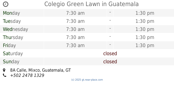
Colegio Green Lawn
8A Calle
School
read more
759 m
Hogar Nazaret
Guatemala
School
read more
790 m
Colegio IMB-PC
Bulevar Principal de Ciudad San Cristóbal 18-50, Guatemala
School
read more
798 m
Colegio Bilingüe Campo Real
8A Calle 12-44, Guatemala
School
read more
799 m
Olé! Escuela De Arte Flamenco
Centro Comercial San Cristobal, Guatemala
School
read more
802 m
Colegio Soñadores
Guatemala City
School
read more
802 m
Colegio Soñadores
Guatemala
School
read more
809 m
Colegio Mundo Americano
Sector B1, Guatemala
School
read more
844 m
Bilingual School IMB-PC
4A Calle, Guatemala
School
read more
844 m
Colegio Bilingüe IMB-PC
4A Calle, Guatemala
School
read more
896 m
Escuela de buceo Pro Diver
San Cristóbal,13 ave C 9-31 sector granjas
School
read more
1.075 km
Colegio Neozelandes Freda Peterson
2A Calle, Guatemala
School
read more
1.144 km
Colegio Santa María de Montesclaros
6-58, 4A Calle, Guatemala
School
read more
1.269 km
Colegio Brooklyn School
Guatemala City
School
read more
1.269 km
Colegio Brooklyn School
Guatemala
School
read more
1.387 km
Centro de cuidado diario Kaboom
5-97,, Boulevard Sur, Guatemala
School
read more
2.178 km
Colegio Campo Nissi
6A Calle, Guatemala
School
read more
📑
all categories
Accounting
Administrative area level 1
Administrative area level 2
Airport
Amusement park
Aquarium
Art gallery
Atm
Bakery
Bank
Bar
Beauty salon
Bicycle store
Book store
Bowling alley
Bus station
Cafe
Campground
Car dealer
Car rental
Car repair
Car wash
Casino
Cemetery
Church
City hall
Clothing store
Colloquial area
Convenience store
Courthouse
Dentist
Department store
Doctor
Electrician
Electronics store
Embassy
Establishment
Finance
Fire station
Florist
Food
Funeral home
Furniture store
Gas station
General contractor
Grocery or supermarket
Gym
Hair care
Hardware store
Health
Hindu Temple
Home goods store
Hospital
Insurance agency
Jewelry store
Laundry
Lawyer
Library
Liquor store
Local government office
Locality
Locksmith
Lodging
Meal delivery
Meal takeaway
Mosque
Movie rental
Movie theater
Moving company
Museum
Natural feature
Neighborhood
Night club
Painter
Park
Parking
Pet store
Pharmacy
Physiotherapist
Place of worship
Plumber
Point of interest
Police
Political
Post office
Premise
Real estate agency
Restaurant
Route
Rv park, camping
School
Shoe store
Shopping mall
Spa
Stadium
Storage
Store
Subway station
Supermarket
Synagogue
Taxi stand
Train station
Transit station
Travel agency
University
Veterinary care
Zoo
administrative area level 3
sublocality level 1
↑