School nearby Centro de Aprendizaje Rafael Landivar
Guatemala
School nearby Centro de Aprendizaje Rafael Landivar
Centro de Aprendizaje Rafael Landivar
Coatepeque, Guatemala
contacts phone
:
+502 7775 3944
website:
www.google.com.gt
Latitude:
14.7062361
, Longitude:
-91.8699503
larger map & directions
read more
nearest School
497 m
Club Animis Lucidum
Coatepeque
School
read more
502 m
Club Animis Lucidum
6a. Calle, Coatepeque
School
read more
506 m
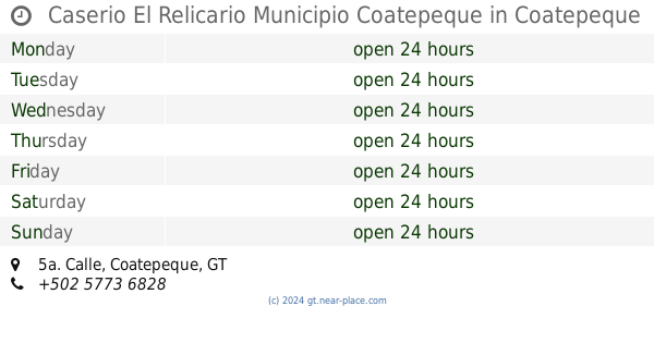
Caserio El Relicario Municipio Coatepeque
5a. Calle, Coatepeque
School
read more
530 m
Universidad DaVinci de Guatemala, Sede Coatepeque
Coatepeque
School
read more
594 m
Colegio Informatica
Coatepeque
School
read more
596 m
Escuela Oscar De Leon Palacios
Coatepeque
School
read more
646 m
colegio Maria Auxiliadora
Coatepeque
School
read more
652 m
Inocencia Lopez de Campollo
Coatepeque
School
read more
712 m
Escuela Oficial Rural Mixta
20 Calle 12 De Octubre, Ponce
School
read more
834 m
Manuel Lisandro Barillas
Coatepeque
School
read more
880 m
Rafael Alvarez Ovalle
Coatepeque
School
read more
927 m
EODP CLUB ROTARIO
Coatepeque
School
read more
952 m
En clave, Estudios Musicales
4ta Avenida, Coatepeque
School
read more
971 m
Colegio San Jose
Coatepeque
School
read more
992 m
INSTITUTO PEDRO MOLINA
4ta Avenida, Coatepeque
School
read more
1.011 km
Academia Comercial y C.A.T. Artemio David Cifuentes Flores
6a. Calle, Coatepeque
School
read more
1.049 km
Manfredo Hemerling
Coatepeque
School
read more
1.051 km
Escuela San Francisco
Coatepeque
School
read more
1.051 km
San Francisco School
Coatepeque
School
read more
1.063 km
IBACH
Coatepeque
School
read more
1.094 km
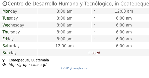
Centro de Desarrollo Humano y Tecnólogico,
Coatepeque
School
read more
1.101 km
COLEGIO MINERBA
Coatepeque
School
read more
1.105 km
Colegio Liceo Infantil Minerva
0 calle Frente a Línea Ferrea, 3-24, Coatepeque
School
read more
1.131 km
Supervision Educativa
Coatepeque
School
read more
1.297 km
Instittuo Nacional Mixto de Orientacion Comercial INMEBOC
Coatepeque
School
read more
📑
all categories
Accounting
Administrative area level 1
Administrative area level 2
Airport
Amusement park
Aquarium
Art gallery
Atm
Bakery
Bank
Bar
Beauty salon
Bicycle store
Book store
Bowling alley
Bus station
Cafe
Campground
Car dealer
Car rental
Car repair
Car wash
Casino
Cemetery
Church
City hall
Clothing store
Colloquial area
Convenience store
Courthouse
Dentist
Department store
Doctor
Electrician
Electronics store
Embassy
Establishment
Finance
Fire station
Florist
Food
Funeral home
Furniture store
Gas station
General contractor
Grocery or supermarket
Gym
Hair care
Hardware store
Health
Hindu Temple
Home goods store
Hospital
Insurance agency
Jewelry store
Laundry
Lawyer
Library
Liquor store
Local government office
Locality
Locksmith
Lodging
Meal delivery
Meal takeaway
Mosque
Movie rental
Movie theater
Moving company
Museum
Natural feature
Neighborhood
Night club
Painter
Park
Parking
Pet store
Pharmacy
Physiotherapist
Place of worship
Plumber
Point of interest
Police
Political
Post office
Premise
Real estate agency
Restaurant
Route
Rv park, camping
School
Shoe store
Shopping mall
Spa
Stadium
Storage
Store
Subway station
Supermarket
Synagogue
Taxi stand
Train station
Transit station
Travel agency
University
Veterinary care
Zoo
administrative area level 3
sublocality level 1
↑