Restaurant nearby Rancho Los Jalapeños
Guatemala
Restaurant nearby Rancho Los Jalapeños
Rancho Los Jalapeños
Chiquimula Guatemala
contacts phone
:
+502
Latitude:
14.7991026
, Longitude:
-89.5518998
read more
nearest Restaurant
192 m
Fonda De Mamá
4a Calle, Chiquimula
Restaurant
read more
298 m
Don Camaron
3a Calle, Chiquimula
Restaurant
read more
306 m
Habitat Café-Bar
Zona 1, Chiquimula
Restaurant
read more
417 m
Cabaña Del Abuelo
Chiquimula
Restaurant
read more
419 m
Churrasqueria El Esfuerzo
Chiquimula
Restaurant
read more
584 m
Kam Chi Fay
5a. Calle, Chiquimula
Restaurant
read more
620 m
Capuccino
Chiquimula
Restaurant
read more
660 m
La Mariscada
Chiquimula
Restaurant
read more
663 m
Restautante Lao Fangzi
6a. Avenida, Chiquimula
Restaurant
read more
681 m
Charlis Pizza
7a. Avenida Zona 1, Chiquimula
Restaurant
read more
683 m
Subway
7a Avenida, Chiquimula
Restaurant
read more
689 m
Pollo Campero
4a Calle, Chiquimula
Restaurant
read more
699 m
Restaurante La Casona
2a Calle, Chiquimula
Restaurant
read more
711 m
Restaurante Y Disco Los Primos
Chiquimula
Restaurant
read more
715 m
Pizza Burger Diner el Calvario
6a Calle, Chiquimula
Restaurant
read more
725 m
Little Ceasers
Chiquimula
Restaurant
read more
761 m
Chino Oriental
6a Calle, Chiquimula
Restaurant
read more
810 m
Comedor Fuente De Vida
8 ave entre 3era y 4ta calle frente a agencia way, Chiquimula
Restaurant
read more
823 m
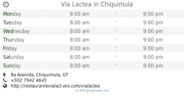
Via Lactea
8a Avenida, Chiquimula
Restaurant
read more
856 m
PepePanes
1a. Calle, Chiquimula
Restaurant
read more
873 m
Billares Tajas
Chiquimula
Restaurant
read more
939 m
The Queens Disco Lounge
Barrio Sasmó Abajo
Restaurant
read more
991 m
29 grados Chiquimula
2-33, 9a Avenida, Chiquimula
Restaurant
read more
1.041 km
Restaurante El Barrial
Chiquimula
Restaurant
read more
1.222 km
Wicho's Churrasco
Chiquimula
Restaurant
read more
📑
all categories
Accounting
Administrative area level 1
Administrative area level 2
Airport
Amusement park
Aquarium
Art gallery
Atm
Bakery
Bank
Bar
Beauty salon
Bicycle store
Book store
Bowling alley
Bus station
Cafe
Campground
Car dealer
Car rental
Car repair
Car wash
Casino
Cemetery
Church
City hall
Clothing store
Colloquial area
Convenience store
Courthouse
Dentist
Department store
Doctor
Electrician
Electronics store
Embassy
Establishment
Finance
Fire station
Florist
Food
Funeral home
Furniture store
Gas station
General contractor
Grocery or supermarket
Gym
Hair care
Hardware store
Health
Hindu Temple
Home goods store
Hospital
Insurance agency
Jewelry store
Laundry
Lawyer
Library
Liquor store
Local government office
Locality
Locksmith
Lodging
Meal delivery
Meal takeaway
Mosque
Movie rental
Movie theater
Moving company
Museum
Natural feature
Neighborhood
Night club
Painter
Park
Parking
Pet store
Pharmacy
Physiotherapist
Place of worship
Plumber
Point of interest
Police
Political
Post office
Premise
Real estate agency
Restaurant
Route
Rv park, camping
School
Shoe store
Shopping mall
Spa
Stadium
Storage
Store
Subway station
Supermarket
Synagogue
Taxi stand
Train station
Transit station
Travel agency
University
Veterinary care
Zoo
administrative area level 3
sublocality level 1
↑