Restaurant nearby La Hacienda Del Rey
Guatemala
Restaurant nearby La Hacienda Del Rey
La Hacienda Del Rey
Flores Guatemala
contacts phone
:
+502
Latitude:
16.9285651
, Longitude:
-89.8930067
read more
nearest Restaurant
84 m
Catamaran RAÍCES
Calle Virgilio Rodriguez Macal, Flores
Restaurant
read more
115 m
Charango Bar Y Restaurante
Flores
Restaurant
read more
172 m
Restaurante Peche's
Flores
Restaurant
read more
183 m
Mayan Princess
Calle 10 de Novembre, Flores
Restaurant
read more
184 m
Legumbres Maya
Calle Centro América, Flores
Restaurant
read more
195 m
Jalapenos
Flores
Restaurant
read more
198 m
Restaurante Bar Jungle Paradise
Calle Centro América, Flores
Restaurant
read more
203 m
Humo en tus ojos
Calle Sur, Flores
Restaurant
read more
213 m
La Villa Del Chef
Flores
Restaurant
read more
215 m
Hotel y Restaurante Casa Amelia
Calle Union, Flores
Lodging
Restaurant
Food
Point of interest
Establishment
read more
220 m
Restaurante Tipico Imperio
Calle 15 de Septiembre, Flores
Restaurant
read more
223 m
Restaurante Cacabel
Flores
Restaurant
read more
229 m
restaurante michael che
Flores
Restaurant
read more
238 m
Restaurante Jalapenos
Calle Union, Flores
Restaurant
read more
252 m
Restaurante Zot'z
15 de Septiembre, Flores
Restaurant
read more
261 m
La Data
Calle 15 de Septiembre, Flores
Restaurant
read more
261 m
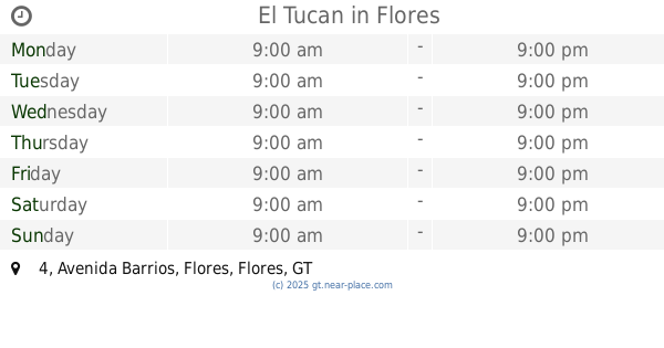
El Tucan
Avenida Barrios 4, Flores
Restaurant
Food
Point of interest
Establishment
read more
291 m
Tipico Imperio
Calle 15 de Septiembre, Flores
Restaurant
read more
296 m
Suico Cafe
Flores
Restaurant
read more
405 m
La Casa de Enrico
Calle la unión Ciudad flores, Flores
Restaurant
Food
Point of interest
Establishment
read more
527 m
Restaurante Totoy's
San Benito
Restaurant
read more
659 m
Rest. El Mexicano Tacos
3 Avenida 1-9, Flores
Restaurant
read more
720 m
Restaurante Maya Internacional
Flores
Restaurant
read more
851 m
Las Violetas
Flores
Restaurant
read more
1.249 km
Los Compadres
San Benito
Restaurant
read more
📑
all categories
Accounting
Administrative area level 1
Administrative area level 2
Airport
Amusement park
Aquarium
Art gallery
Atm
Bakery
Bank
Bar
Beauty salon
Bicycle store
Book store
Bowling alley
Bus station
Cafe
Campground
Car dealer
Car rental
Car repair
Car wash
Casino
Cemetery
Church
City hall
Clothing store
Colloquial area
Convenience store
Courthouse
Dentist
Department store
Doctor
Electrician
Electronics store
Embassy
Establishment
Finance
Fire station
Florist
Food
Funeral home
Furniture store
Gas station
General contractor
Grocery or supermarket
Gym
Hair care
Hardware store
Health
Hindu Temple
Home goods store
Hospital
Insurance agency
Jewelry store
Laundry
Lawyer
Library
Liquor store
Local government office
Locality
Locksmith
Lodging
Meal delivery
Meal takeaway
Mosque
Movie rental
Movie theater
Moving company
Museum
Natural feature
Neighborhood
Night club
Painter
Park
Parking
Pet store
Pharmacy
Physiotherapist
Place of worship
Plumber
Point of interest
Police
Political
Post office
Premise
Real estate agency
Restaurant
Route
Rv park, camping
School
Shoe store
Shopping mall
Spa
Stadium
Storage
Store
Subway station
Supermarket
Synagogue
Taxi stand
Train station
Transit station
Travel agency
University
Veterinary care
Zoo
administrative area level 3
sublocality level 1
↑