Restaurant nearby Antojitos “Doña Linda”
Guatemala
Restaurant nearby Antojitos “Doña Linda”
Antojitos “Doña Linda”
San Jacinto Guatemala
contacts phone
:
+502
Latitude:
14.6776241
, Longitude:
-89.5023922
read more
nearest Restaurant
181 m
Pollo Granjero Restaurante
San Jacinto
Restaurant
read more
8.784 km
Mi Ranchito
Aldea Sábana Grande
Restaurant
read more
9.033 km
Restaurante Y Steak House La Granja
1, Chiquimula
Restaurant
read more
10.225 km
Antojitos La Bendición
San Jose La Arada
Restaurant
read more
12.736 km
Hacienda Don Miguel
Chiquimula
Restaurant
read more
13.381 km
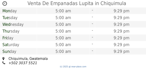
Venta De Empanadas Lupita
Chiquimula
Restaurant
read more
13.569 km
Restaurante El Barrial
Chiquimula
Restaurant
read more
13.662 km
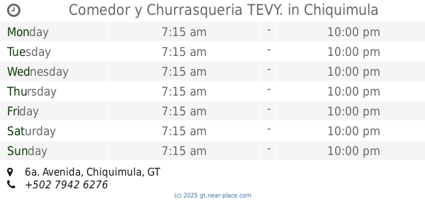
Comedor y Churrasqueria TEVY.
6a. Avenida, Chiquimula
Restaurant
read more
13.926 km
4 Caldos
5a. Calle, Chiquimula
Restaurant
read more
14.017 km
JUANES CHIQUIMULA
Chiquimula
Restaurant
read more
14.085 km
Capuccino
Chiquimula
Restaurant
read more
14.117 km
Charlis Pizza
7a. Avenida Zona 1, Chiquimula
Restaurant
read more
14.205 km
Kam Chi Fay
Chiquimula
Restaurant
read more
14.345 km
Joe`s Pizzs Concepcion Las Minas chiquimula
2a Calle, Chiquimula
Restaurant
read more
14.416 km
Billares Tajas
Chiquimula
Restaurant
read more
14.484 km
Cabaña Del Abuelo
Chiquimula
Restaurant
read more
14.569 km
Chévere
RN-18, Ipala
Restaurant
read more
14.586 km
Restautante Lao Fangzi
6a. Avenida, Chiquimula
Restaurant
read more
14.624 km
Fonda De Mamá
4a Calle, Chiquimula
Restaurant
read more
14.674 km
PepePanes
1a. Calle, Chiquimula
Restaurant
read more
14.68 km
Don Camaron
3a Calle, Chiquimula
Restaurant
read more
14.818 km
McDonald's
Centro Comercial Pradera Chiquimula, Km 167.5 Ruta Esquipulas, Esquipulas
Restaurant
read more
14.984 km
Marea Roja
Ingreso CCI, Chiquimula
Restaurant
read more
15.133 km
Wicho's Churrasco
Chiquimula
Restaurant
read more
16.891 km
Belén Vivero Café
Chiquimula
Restaurant
read more
📑
all categories
Accounting
Administrative area level 1
Administrative area level 2
Airport
Amusement park
Aquarium
Art gallery
Atm
Bakery
Bank
Bar
Beauty salon
Bicycle store
Book store
Bowling alley
Bus station
Cafe
Campground
Car dealer
Car rental
Car repair
Car wash
Casino
Cemetery
Church
City hall
Clothing store
Colloquial area
Convenience store
Courthouse
Dentist
Department store
Doctor
Electrician
Electronics store
Embassy
Establishment
Finance
Fire station
Florist
Food
Funeral home
Furniture store
Gas station
General contractor
Grocery or supermarket
Gym
Hair care
Hardware store
Health
Hindu Temple
Home goods store
Hospital
Insurance agency
Jewelry store
Laundry
Lawyer
Library
Liquor store
Local government office
Locality
Locksmith
Lodging
Meal delivery
Meal takeaway
Mosque
Movie rental
Movie theater
Moving company
Museum
Natural feature
Neighborhood
Night club
Painter
Park
Parking
Pet store
Pharmacy
Physiotherapist
Place of worship
Plumber
Point of interest
Police
Political
Post office
Premise
Real estate agency
Restaurant
Route
Rv park, camping
School
Shoe store
Shopping mall
Spa
Stadium
Storage
Store
Subway station
Supermarket
Synagogue
Taxi stand
Train station
Transit station
Travel agency
University
Veterinary care
Zoo
administrative area level 3
sublocality level 1
↑