Pharmacy nearby Farmacia Don Vicente
Guatemala
Pharmacy nearby Farmacia Don Vicente
Farmacia Don Vicente
4a Calle, Retalhuleu, GT Guatemala
contacts phone
:
+502
Latitude:
14.5346707
, Longitude:
-91.6803047
larger map & directions
read more
nearest Pharmacy
20 m
Farmacia Paiz
5 Avenida A, Retalhuleu
Pharmacy
read more
22 m
Farmacia El Centro
2a Calle 5-49, Retalhuleu
Pharmacy
read more
45 m
Farmacia Superior
6a Avenida, Retalhuleu
Pharmacy
read more
110 m
Farmacia De La Comunidad
Retalhuleu
Pharmacy
read more
145 m
Farmacia Bateres
5 Avenida A, Retalhuleu
Pharmacy
read more
205 m
Farmacia Batres
A,, 5a Avenida, Retalhuleu
Pharmacy
read more
246 m
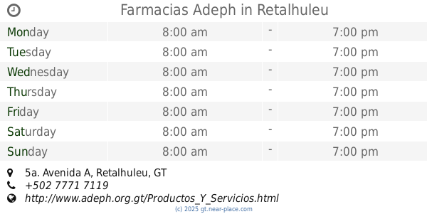
Farmacias Adeph
5a. Avenida A, Retalhuleu
Pharmacy
read more
250 m
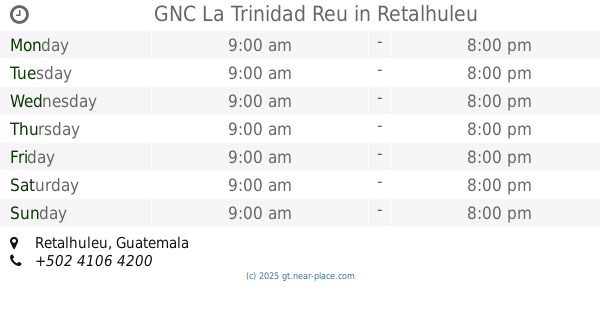
GNC La Trinidad Reu
Retalhuleu
Pharmacy
read more
266 m
Farmacias Alpina
5a. Avenida A, Retalhuleu
Pharmacy
read more
338 m
Farmacia San Antonio
5 Avenida A, Retalhuleu
Pharmacy
read more
339 m
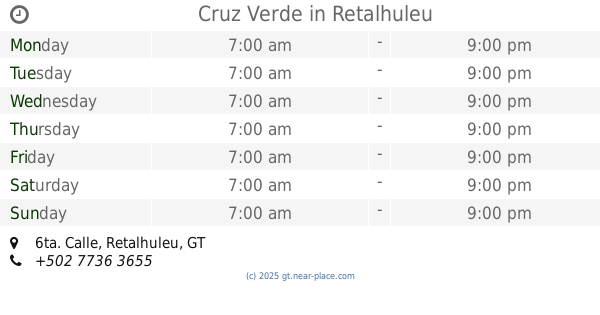
Cruz Verde
6ta. Calle, Retalhuleu
Pharmacy
read more
407 m
Farmacia Santa Lucia
6a Calle, Retalhuleu
Pharmacy
read more
416 m
Farmacia Super Descuento
Retalhuleu
Pharmacy
read more
455 m
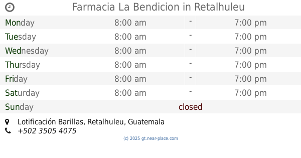
Farmacia La Bendicion
Lotificación Barillas
Pharmacy
read more
466 m
Farmacia y Clinica de Prevención del Cancer Club Los Once
Retalhuleu
Pharmacy
read more
471 m
Farmacia La Sevillana
Retalhuleu
Pharmacy
read more
484 m
Farmacia Galeno Retalhuleu
6-84,, 7a Calle, Retalhuleu
Pharmacy
read more
587 m
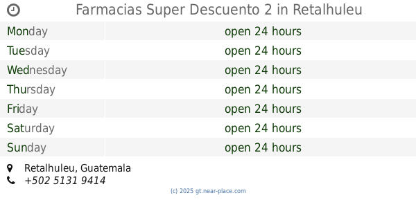
Farmacias Super Descuento 2
Retalhuleu
Pharmacy
read more
638 m
Pharmacy Health
7a Avenida, Retalhuleu
Pharmacy
read more
726 m
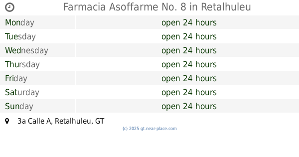
Farmacia Asoffarme No. 8
10-10 zona 4 Residenciales Ana Lucia, 3a Calle A, Retalhuleu
Pharmacy
read more
791 m
Farmacia Karlita
8a9, 82 zona, 1 Avenida
Pharmacy
read more
801 m
Farmacia Social
Avenida del Cementerio, Retalhuleu
Pharmacy
read more
806 m
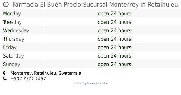
Farmacía El Buen Precio Sucursal Monterrey
Monterrey, Retalhuleu
Pharmacy
read more
835 m
Farmacia Fiorini Asoffarme No. 2
11 Calle, Retalhuleu
Pharmacy
read more
1.014 km
Farmacia Social La Salvación Del Pueblo
Retalhuleu
Pharmacy
read more
📑
all categories
Accounting
Administrative area level 1
Administrative area level 2
Airport
Amusement park
Aquarium
Art gallery
Atm
Bakery
Bank
Bar
Beauty salon
Bicycle store
Book store
Bowling alley
Bus station
Cafe
Campground
Car dealer
Car rental
Car repair
Car wash
Casino
Cemetery
Church
City hall
Clothing store
Colloquial area
Convenience store
Courthouse
Dentist
Department store
Doctor
Electrician
Electronics store
Embassy
Establishment
Finance
Fire station
Florist
Food
Funeral home
Furniture store
Gas station
General contractor
Grocery or supermarket
Gym
Hair care
Hardware store
Health
Hindu Temple
Home goods store
Hospital
Insurance agency
Jewelry store
Laundry
Lawyer
Library
Liquor store
Local government office
Locality
Locksmith
Lodging
Meal delivery
Meal takeaway
Mosque
Movie rental
Movie theater
Moving company
Museum
Natural feature
Neighborhood
Night club
Painter
Park
Parking
Pet store
Pharmacy
Physiotherapist
Place of worship
Plumber
Point of interest
Police
Political
Post office
Premise
Real estate agency
Restaurant
Route
Rv park, camping
School
Shoe store
Shopping mall
Spa
Stadium
Storage
Store
Subway station
Supermarket
Synagogue
Taxi stand
Train station
Transit station
Travel agency
University
Veterinary care
Zoo
administrative area level 3
sublocality level 1
↑