Park nearby El Chorro del Carmen
Guatemala
Park nearby El Chorro del Carmen
El Chorro del Carmen
Kilómetro 164 desde la Capital, Zunilito, Suchitepéquez hacia aldea San, Lorencito, Aldea San Lorencito, Zunilito, Suchitepéquez Guatemala
contacts phone
:
+502
Latitude:
14.638382
, Longitude:
-91.499382
read more
nearest Park
3.222 km
Parque central
Zunilito
Park
read more
3.222 km
central Park
Zunilito
Park
read more
4.639 km
Parque Municipal, Pueblo Nuevo
Pueblo Nuevo
Park
read more
4.639 km
Municipal, Pueblo Nuevo Park
Pueblo Nuevo
Park
read more
5.905 km
Parque Municipal de San Francisco Zapotitlán
Parque Municipal, San Francisco Zapotitlán
Park
read more
7.433 km
Vuelo Extremo - Canopy
Retalhuleu
Park
read more
9.47 km
Central Park
Santo Tomás La Unión, Suchitepéquez
Park
read more
9.47 km
Parque Central
Santo Tomás La Unión, Suchitepéquez
Park
read more
10.437 km
Aldea Tzamabaj
Tzamabaj
Park
read more
10.601 km
San Felipe Retalhuleu Central Park
San Felipe
Park
read more
10.601 km
Parque Central de San Felipe Retalhuleu
San Felipe
Park
read more
11.07 km
Campo de Futbol
San Felipe
Park
read more
11.33 km
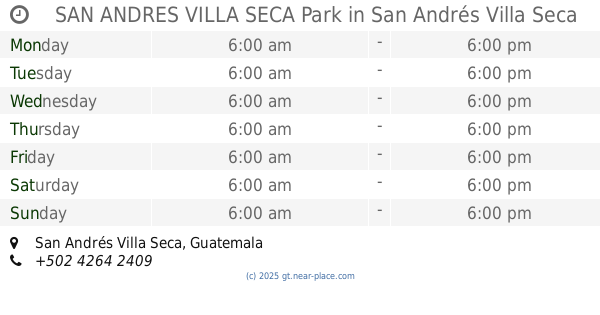
SAN ANDRES VILLA SECA Park
San Andrés Villa Seca
Park
read more
11.33 km
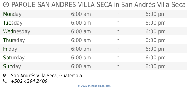
PARQUE SAN ANDRES VILLA SECA
San Andrés Villa Seca
Park
read more
11.333 km
Col. La Cañada Park
Mazatenango
Park
read more
11.506 km
Reserva Ecológica
Mazatenango
Park
read more
11.542 km
Parque de San Bernardino
San Bernardino
Park
read more
11.561 km
Parque Central de Mazatenango
Mazatenango
Park
read more
11.842 km
Flor del Café Park
Mazatenango
Park
read more
11.861 km
Parque Urbano
Mazatenango
Park
read more
12.042 km
Municipal Park
San Martín Zapotitlán
Park
read more
12.055 km
Parque Municipal
San Martin Zapotitlán
Park
read more
13.507 km
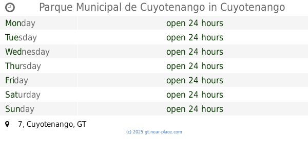
Parque Municipal de Cuyotenango
7, Cuyotenango
Park
read more
14.82 km
Santa Cruz Muluá Park
Santa Cruz Muluá
Park
read more
15.467 km
La Meseta
Guatemala
Park
read more
📑
all categories
Accounting
Administrative area level 1
Administrative area level 2
Airport
Amusement park
Aquarium
Art gallery
Atm
Bakery
Bank
Bar
Beauty salon
Bicycle store
Book store
Bowling alley
Bus station
Cafe
Campground
Car dealer
Car rental
Car repair
Car wash
Casino
Cemetery
Church
City hall
Clothing store
Colloquial area
Convenience store
Courthouse
Dentist
Department store
Doctor
Electrician
Electronics store
Embassy
Establishment
Finance
Fire station
Florist
Food
Funeral home
Furniture store
Gas station
General contractor
Grocery or supermarket
Gym
Hair care
Hardware store
Health
Hindu Temple
Home goods store
Hospital
Insurance agency
Jewelry store
Laundry
Lawyer
Library
Liquor store
Local government office
Locality
Locksmith
Lodging
Meal delivery
Meal takeaway
Mosque
Movie rental
Movie theater
Moving company
Museum
Natural feature
Neighborhood
Night club
Painter
Park
Parking
Pet store
Pharmacy
Physiotherapist
Place of worship
Plumber
Point of interest
Police
Political
Post office
Premise
Real estate agency
Restaurant
Route
Rv park, camping
School
Shoe store
Shopping mall
Spa
Stadium
Storage
Store
Subway station
Supermarket
Synagogue
Taxi stand
Train station
Transit station
Travel agency
University
Veterinary care
Zoo
administrative area level 3
sublocality level 1
↑