Park nearby Central, La Unión, Zacapa Park
Coronavirus disease (COVID-19) Situation
confirmed cases
1291293
deaths
20289
Guatemala
Park nearby Central, La Unión, Zacapa Park
Central, La Unión, Zacapa Park
La Unión Guatemala
contacts phone
:
+502
Latitude:
14.9660294
, Longitude:
-89.291469
read more
nearest Park
Parque Central, La Unión, Zacapa
La Unión
Park
read more
16.992 km
Parque Ecológico Brisas Del Rosario.
Chiquimula
Park
read more
16.992 km
Brisas Del Rosario. Ecological Park
Chiquimula
Park
read more
18.178 km
Predio CAMOTAN
Calle Principal Camotan, Camotán
Park
read more
18.417 km
Parque Central Camotán
Camotán
Park
read more
18.417 km
Camotán Central Park
Camotán
Park
read more
19.285 km
Jocotan Parque Central
5, Camotán
Park
read more
19.331 km
Parque San Sebastian
Jocotán
Park
read more
19.955 km
Parque Centroamérica
Jocotán
Park
read more
20.692 km
MENACHOR Botanical Garden
Jocotàn
Park
read more
20.692 km
Jardín Botánico MENACHOR
Jocotàn
Park
read more
24.208 km
Parque
Jumuzna
Park
read more
24.924 km
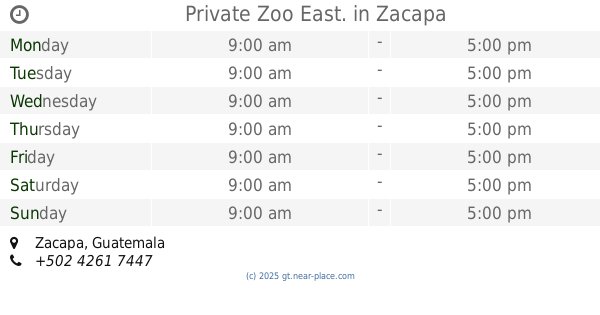
Private Zoo East.
Zacapa
Park
read more
24.924 km
Zoológico Privado de Oriente.
Zacapa
Park
read more
25.635 km
Parque
Santa Lucía
Park
read more
25.993 km
Y Mirador Por La Paz Park
Guatemala
Park
read more
25.993 km
Parque Y Mirador Por La Paz
Guatemala
Park
read more
26.764 km
Exotic Cactus
San Juan Ermita
Park
read more
26.961 km
Parque Central
San Juan Ermita
Park
read more
26.961 km
Central Park
San Juan Ermita
Park
read more
28.596 km
Parque Central, Los Planes, San Juar Ermita
Chiquimula
Park
read more
28.596 km
Central, Los Planes, San Juar Ermita Park
Chiquimula
Park
read more
34.117 km
Parque San Esteban
San Esteban
Park
read more
34.117 km
San Esteban Park
San Esteban
Park
read more
41.598 km
Parque Central
San José La Arada
Park
read more
📑
all categories
Accounting
Administrative area level 1
Administrative area level 2
Airport
Amusement park
Aquarium
Art gallery
Atm
Bakery
Bank
Bar
Beauty salon
Bicycle store
Book store
Bowling alley
Bus station
Cafe
Campground
Car dealer
Car rental
Car repair
Car wash
Casino
Cemetery
Church
City hall
Clothing store
Colloquial area
Convenience store
Courthouse
Dentist
Department store
Doctor
Electrician
Electronics store
Embassy
Establishment
Finance
Fire station
Florist
Food
Funeral home
Furniture store
Gas station
General contractor
Grocery or supermarket
Gym
Hair care
Hardware store
Health
Hindu Temple
Home goods store
Hospital
Insurance agency
Jewelry store
Laundry
Lawyer
Library
Liquor store
Local government office
Locality
Locksmith
Lodging
Meal delivery
Meal takeaway
Mosque
Movie rental
Movie theater
Moving company
Museum
Natural feature
Neighborhood
Night club
Painter
Park
Parking
Pet store
Pharmacy
Physiotherapist
Place of worship
Plumber
Point of interest
Police
Political
Post office
Premise
Real estate agency
Restaurant
Route
Rv park, camping
School
Shoe store
Shopping mall
Spa
Stadium
Storage
Store
Subway station
Supermarket
Synagogue
Taxi stand
Train station
Transit station
Travel agency
University
Veterinary care
Zoo
administrative area level 3
sublocality level 1
↑