Park nearby Campo De Futbol
Guatemala
Park nearby Campo De Futbol
Campo De Futbol
Cuyuta Guatemala
contacts phone
:
+502
Latitude:
14.101592
, Longitude:
-90.8816813
read more
nearest Park
15.91 km
Parqué Cebtral De La Democracia Escuintla
La Democracia
Park
read more
18.192 km
Parque
La Gomera
Park
read more
18.368 km
Parque Tecun Uman
Tecun Uman, Parque La Gomera, Guatemala
Park
read more
23.977 km
parque de la industria
Escuintla
Park
read more
24.453 km
Parque Central de Escuintla
9 Calle, Escuintla
Park
read more
24.898 km
San Sebastian
Escuintla
Park
read more
44.988 km
Parque Central
1a calle y 3a Ave, 1, San Pedro Yepocapa
Park
read more
46.635 km
Patulul Central Park
11, Patulul
Park
read more
46.788 km
Parque Natural Calderas
Guatemala
Park
read more
47.782 km
Ceiba Gallardo
Guatemala
Park
read more
49.213 km
Senderos del Níspero
Guatemala
Park
read more
50.041 km
Plazuela San Pedro las Huertas
San Pedro Las Huertas
Park
read more
51.544 km
Finca San Ignacio
5 Avenida Sur 6, Antigua Guatemala
Park
read more
54.281 km
Los Tarrales Natural Reserve
km 164.2 Ruta Nacional 11, Patulul, Suchitepéquez
Park
read more
55.266 km
Condominio Alamedas De De San Miguel
Villa Nueva
Park
read more
55.719 km
Mirador Del Lago Amatitlán
Ruta Santa Elena Barillas - Circunvalacion al Lago
Park
read more
55.945 km
Fuentes 4 Park
Unnamed Road,, Villa Nueva
Park
read more
56.22 km
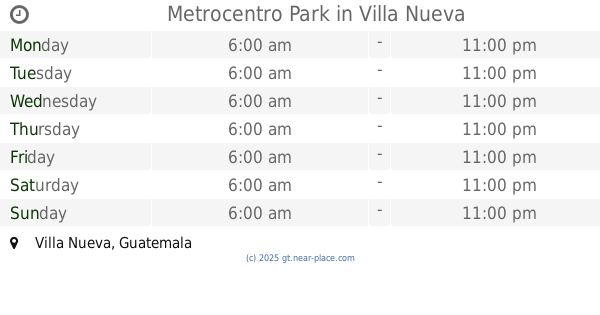
Metrocentro Park
Villa Nueva
Park
read more
56.855 km
Parque Central Colinas Del Paraiso 2
Guatemala
Park
read more
57.929 km
Los Andes Nature Reserve
Guatemala
Park
read more
57.931 km
Area De Recreacion Fuentes Del Valle II
Villa Nueva
Park
read more
58.062 km
Parque San Jose el Placer
Villa Nueva
Park
read more
59.3 km
Soccer Field Prados
Guatemala
Park
read more
62.005 km
Justo Rufino Barrios Park
Zona 21,Guatemala
Park
read more
67.474 km
Parque Polideportivo Don Justo
Guatemala City
Park
read more
📑
all categories
Accounting
Administrative area level 1
Administrative area level 2
Airport
Amusement park
Aquarium
Art gallery
Atm
Bakery
Bank
Bar
Beauty salon
Bicycle store
Book store
Bowling alley
Bus station
Cafe
Campground
Car dealer
Car rental
Car repair
Car wash
Casino
Cemetery
Church
City hall
Clothing store
Colloquial area
Convenience store
Courthouse
Dentist
Department store
Doctor
Electrician
Electronics store
Embassy
Establishment
Finance
Fire station
Florist
Food
Funeral home
Furniture store
Gas station
General contractor
Grocery or supermarket
Gym
Hair care
Hardware store
Health
Hindu Temple
Home goods store
Hospital
Insurance agency
Jewelry store
Laundry
Lawyer
Library
Liquor store
Local government office
Locality
Locksmith
Lodging
Meal delivery
Meal takeaway
Mosque
Movie rental
Movie theater
Moving company
Museum
Natural feature
Neighborhood
Night club
Painter
Park
Parking
Pet store
Pharmacy
Physiotherapist
Place of worship
Plumber
Point of interest
Police
Political
Post office
Premise
Real estate agency
Restaurant
Route
Rv park, camping
School
Shoe store
Shopping mall
Spa
Stadium
Storage
Store
Subway station
Supermarket
Synagogue
Taxi stand
Train station
Transit station
Travel agency
University
Veterinary care
Zoo
administrative area level 3
sublocality level 1
↑