Lodging nearby Hospedaje San Diego
Guatemala
Lodging nearby Hospedaje San Diego
Hospedaje San Diego
Huehuetenango Guatemala
contacts phone
:
+502
Latitude:
15.3240962
, Longitude:
-91.4658135
read more
nearest Lodging
230 m
Don Delfi
3-42, zona 2,, 4a Avenida 4a Avenida Zona 2, Huehuetenango
Lodging
read more
263 m
Hotel Luna Bella
Huehuetenango
Lodging
read more
362 m
HOTEL VICTORIA
Huehuetenango
Lodging
read more
387 m
Hotel Mary
Huehuetenango
Lodging
read more
440 m
Hotel El Centro
3ra calle 2-65, Huehuetenango
Lodging
read more
461 m
Hotel Shinula
Huehuetenango
Lodging
read more
508 m
Hotel Gobernador
4a. Avenida 1-45 zona 1, Huehuetenango
Lodging
read more
508 m
Hotel Maya
3a Calle 3-55, Huehuetenango
Lodging
read more
520 m
Hotel Premier
2a Calle, Huehuetenango
Lodging
read more
568 m
Hotel Central
Huehuetenango
Lodging
read more
589 m
Hotel Zaculeu
5a Avenida, Huehuetenango
Lodging
read more
598 m
Hotel Zaculeu
1a Calle, Huehuetenango
Lodging
read more
667 m
LERRI COLONIAL
6ta Avenida, Huehuetenango
Lodging
read more
693 m
Royal Park Hotel
6a Avenida 1, Huehuetenango
Lodging
read more
699 m
Hotel La Sexta
Huehuetenango
Lodging
read more
750 m
Hotel Todos Santos Inn
Huehuetenango
Lodging
read more
780 m
Hotel San Luis de La Sierra
Huehuetenango
Lodging
read more
793 m
Posada Familiar
Huehuetenango
Lodging
read more
822 m
Hotel Casa Blanca
7a Avenida, Huehuetenango
Lodging
read more
908 m
Hotel Residence
Huehuetenango
Lodging
read more
919 m
Hotel Los Angeles
Huehuetenango
Lodging
read more
1.052 km
Hotel Ruinas Resort
Huehuetenango
Lodging
read more
1.076 km
Hotel Casa Del Viajero
7-70 5, 9a. Avenida, Huehuetenango
Lodging
read more
1.159 km
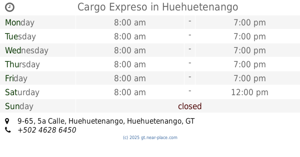
Cargo Expreso
5a Calle 9-65, Huehuetenango
Lodging
read more
1.928 km
Hotel Del Bosque
Huehuetenango
Lodging
read more
📑
all categories
Accounting
Administrative area level 1
Administrative area level 2
Airport
Amusement park
Aquarium
Art gallery
Atm
Bakery
Bank
Bar
Beauty salon
Bicycle store
Book store
Bowling alley
Bus station
Cafe
Campground
Car dealer
Car rental
Car repair
Car wash
Casino
Cemetery
Church
City hall
Clothing store
Colloquial area
Convenience store
Courthouse
Dentist
Department store
Doctor
Electrician
Electronics store
Embassy
Establishment
Finance
Fire station
Florist
Food
Funeral home
Furniture store
Gas station
General contractor
Grocery or supermarket
Gym
Hair care
Hardware store
Health
Hindu Temple
Home goods store
Hospital
Insurance agency
Jewelry store
Laundry
Lawyer
Library
Liquor store
Local government office
Locality
Locksmith
Lodging
Meal delivery
Meal takeaway
Mosque
Movie rental
Movie theater
Moving company
Museum
Natural feature
Neighborhood
Night club
Painter
Park
Parking
Pet store
Pharmacy
Physiotherapist
Place of worship
Plumber
Point of interest
Police
Political
Post office
Premise
Real estate agency
Restaurant
Route
Rv park, camping
School
Shoe store
Shopping mall
Spa
Stadium
Storage
Store
Subway station
Supermarket
Synagogue
Taxi stand
Train station
Transit station
Travel agency
University
Veterinary care
Zoo
administrative area level 3
sublocality level 1
↑