Local government office nearby Zona Vial No. 4 "Caminos"
Guatemala
Local government office nearby Zona Vial No. 4 "Caminos"
Zona Vial No. 4 "Caminos"
Salamá Guatemala
contacts phone
:
+502
Latitude:
15.1044073
, Longitude:
-90.3092195
read more
nearest Local government office
602 m
Rapidito Express BV
Salamá
Local government office
read more
2.04 km
IGSS Salama
Salamá
Local government office
read more
8.658 km
Juzgado de Paz, San Jeronimo, Baja Verapaz.
San Jerónimo
Local government office
read more
8.765 km
Municipalidad de San Jerónimo
2. Calle 1-39 Zona 4 Barrio Arriba. San Jeronimo. Baja Verapaz, 1 Calle 1-39, San Jerónimo
Local government office
read more
17.295 km
Juzgado de Paz, Purulha, Baja Verapaz.
Purulha
Local government office
read more
17.301 km
Juzgado de Paz
Purulha
Local government office
read more
20.219 km
Puesto De Salud De Pasmolón
Pasmolón, Tactic
Local government office
read more
24.261 km
Policia Nacional Civil
Tactic
Local government office
read more
24.261 km
Civil national police
Tactic
Local government office
read more
31.046 km
Palacio Municipal De Granados B.V.
Granados
Local government office
read more
34.722 km
Direccion Departamental de Educacion de Alta Verapaz
1 Calle, 5, 19, Cobán
Local government office
read more
36.998 km
Centro De Salud Comunitario De Saquijá
Guatemala
Local government office
read more
38.237 km
Centro Preventivo de Guastatoya
Guastatoya
Local government office
read more
38.759 km
Estacion PNC
Unnamed Road,, San José del Golfo
Local government office
read more
40.813 km
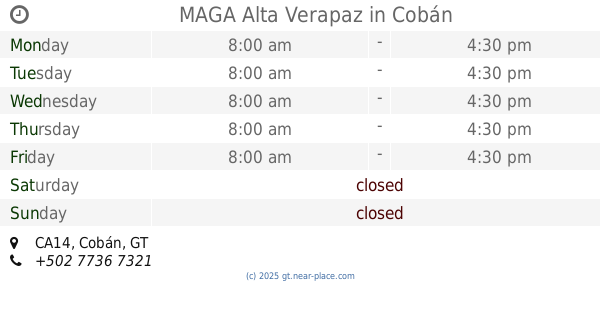
MAGA Alta Verapaz
Km 210 Finca Sachamach, CA14, Cobán
Local government office
read more
41.144 km
Instituto De La Defensa Pública Penal
2a Calle, Cobán
Local government office
read more
41.177 km
ProdeNorte
Cobán
Local government office
read more
41.825 km
INFOM -Sede Verapaces-
Periferico, Cobán
Local government office
read more
41.915 km
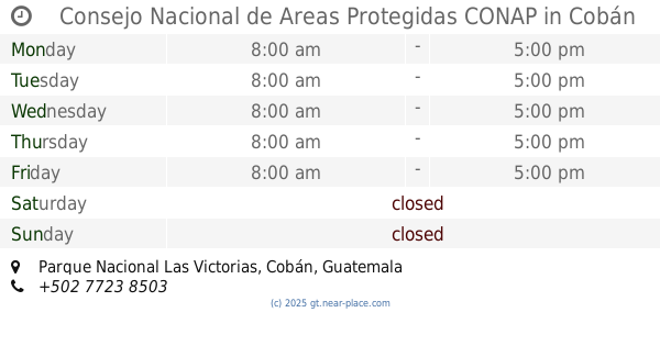
Consejo Nacional de Areas Protegidas CONAP
Parque Nacional Las Victorias, Cobán
Local government office
read more
43.408 km
Puesto de Salud Xeul Pajales
Xeul Pajales,, Cubulco
Local government office
read more
50.688 km
Ministerio Público Chinautla
Guatemala
Local government office
read more
50.832 km
Municipalidad De Chinautla
2A Calle, Guatemala
Local government office
read more
55.492 km
Res. Santa Isabel
Unnamed Road
Local government office
read more
55.779 km
Transportes Jorfee
8-90,, 27 Avenida, Guatemala
Local government office
read more
67.948 km
REGISTRO MERCANTIL
Guatemala
Local government office
read more
📑
all categories
Accounting
Administrative area level 1
Administrative area level 2
Airport
Amusement park
Aquarium
Art gallery
Atm
Bakery
Bank
Bar
Beauty salon
Bicycle store
Book store
Bowling alley
Bus station
Cafe
Campground
Car dealer
Car rental
Car repair
Car wash
Casino
Cemetery
Church
City hall
Clothing store
Colloquial area
Convenience store
Courthouse
Dentist
Department store
Doctor
Electrician
Electronics store
Embassy
Establishment
Finance
Fire station
Florist
Food
Funeral home
Furniture store
Gas station
General contractor
Grocery or supermarket
Gym
Hair care
Hardware store
Health
Hindu Temple
Home goods store
Hospital
Insurance agency
Jewelry store
Laundry
Lawyer
Library
Liquor store
Local government office
Locality
Locksmith
Lodging
Meal delivery
Meal takeaway
Mosque
Movie rental
Movie theater
Moving company
Museum
Natural feature
Neighborhood
Night club
Painter
Park
Parking
Pet store
Pharmacy
Physiotherapist
Place of worship
Plumber
Point of interest
Police
Political
Post office
Premise
Real estate agency
Restaurant
Route
Rv park, camping
School
Shoe store
Shopping mall
Spa
Stadium
Storage
Store
Subway station
Supermarket
Synagogue
Taxi stand
Train station
Transit station
Travel agency
University
Veterinary care
Zoo
administrative area level 3
sublocality level 1
↑