Local government office nearby Puesto De Salud De Cecacao
Guatemala
Local government office nearby Puesto De Salud De Cecacao
Puesto De Salud De Cecacao
Cecacao, Raxruhá Guatemala
contacts phone
:
+502
Latitude:
15.8838259
, Longitude:
-90.1467943
read more
nearest Local government office
7.118 km
Puesto de Salud de Yalpemech
Guatemala
Local government office
read more
11.47 km
Terminal de Buses
Raxruhá
Local government office
read more
11.472 km
Juzgado de Paz
Barrio San José, Raxruhá
Local government office
read more
17.5 km
Centro de Salud de Chisec
Chisec
Local government office
read more
48.307 km
Bodega Municipal
San Pedro Carchá
Local government office
read more
48.412 km
Muni Carcha
San Pedro Carchá
Local government office
read more
51.353 km
INFOM -Sede Verapaces-
Periferico, Cobán
Local government office
read more
51.357 km
Secretaría Presidencial de la Mujer
Cobán
Local government office
read more
51.384 km
ProdeNorte
Cobán
Local government office
read more
51.807 km
Instituto De La Defensa Pública Penal
2a Calle, Cobán
Local government office
read more
51.892 km
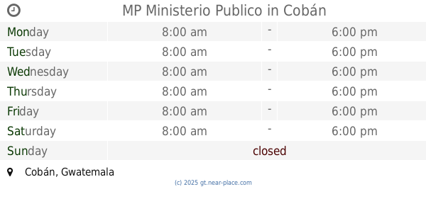
MP Ministerio Publico
Cobán
Local government office
read more
51.949 km
SVET COBAN
3A Calle, Cobán
Local government office
read more
51.959 km
IG
1a Calle, Cobán
Local government office
read more
52.02 km
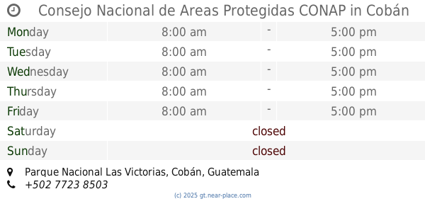
Consejo Nacional de Areas Protegidas CONAP
Parque Nacional Las Victorias, Cobán
Local government office
read more
52.041 km
Palacio De Gobernacion
Cobán
Local government office
read more
52.06 km
CODISRA COBAN
3-25, 1a Calle 1-11, Cobán
Local government office
read more
52.312 km
MAYCOM, COBÁN
1-11,, 10a Avenida, Cobán
Local government office
read more
52.834 km
Centro De Salud Comunitario De Saquijá
Guatemala
Local government office
read more
53.676 km
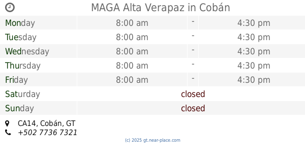
MAGA Alta Verapaz
Km 210 Finca Sachamach, CA14, Cobán
Local government office
read more
📑
all categories
Accounting
Administrative area level 1
Administrative area level 2
Airport
Amusement park
Aquarium
Art gallery
Atm
Bakery
Bank
Bar
Beauty salon
Bicycle store
Book store
Bowling alley
Bus station
Cafe
Campground
Car dealer
Car rental
Car repair
Car wash
Casino
Cemetery
Church
City hall
Clothing store
Colloquial area
Convenience store
Courthouse
Dentist
Department store
Doctor
Electrician
Electronics store
Embassy
Establishment
Finance
Fire station
Florist
Food
Funeral home
Furniture store
Gas station
General contractor
Grocery or supermarket
Gym
Hair care
Hardware store
Health
Hindu Temple
Home goods store
Hospital
Insurance agency
Jewelry store
Laundry
Lawyer
Library
Liquor store
Local government office
Locality
Locksmith
Lodging
Meal delivery
Meal takeaway
Mosque
Movie rental
Movie theater
Moving company
Museum
Natural feature
Neighborhood
Night club
Painter
Park
Parking
Pet store
Pharmacy
Physiotherapist
Place of worship
Plumber
Point of interest
Police
Political
Post office
Premise
Real estate agency
Restaurant
Route
Rv park, camping
School
Shoe store
Shopping mall
Spa
Stadium
Storage
Store
Subway station
Supermarket
Synagogue
Taxi stand
Train station
Transit station
Travel agency
University
Veterinary care
Zoo
administrative area level 3
sublocality level 1
↑