Local government office nearby Estación Policia Nacional Civil
Guatemala
Local government office nearby Estación Policia Nacional Civil
Estación Policia Nacional Civil
San Antonio Ilotenango Guatemala
contacts phone
:
+502
Latitude:
15.0551847
, Longitude:
-91.2267113
read more
nearest Local government office
8.528 km
INFOM -Sede Quiché-
Santa Cruz del Quiché
Local government office
read more
8.825 km
Palacio de Gobernacion Departamental
Santa Cruz del Quiché
Local government office
read more
9.374 km
Delegacion CGC Quiche
Santa Cruz del Quiché
Local government office
read more
20.947 km
Joel iglesia ref guillermo
canton juchanep-, Totonicapán
Local government office
read more
26.093 km
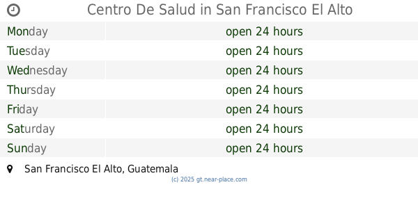
Centro De Salud San Francisco El Alto
Unnamed Road, San Francisco El Alto
Local government office
read more
26.104 km
Centro De Salud
San Francisco El Alto
Local government office
read more
26.104 km
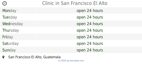
Clinic
San Francisco El Alto
Local government office
read more
26.246 km
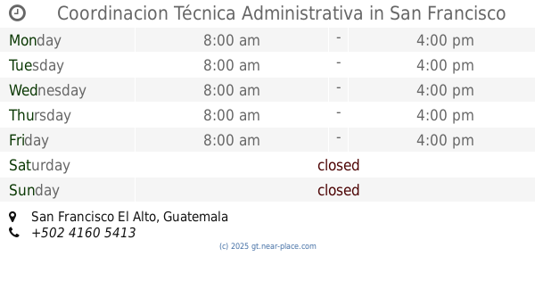
Coordinacion Técnica Administrativa
San Francisco El Alto
Local government office
read more
27.619 km
RENAP- San Cristóbal Totonicapán.
San Cristóbal Totonicapán
Local government office
read more
27.692 km
Municipalidad de San Cristobal
San Cristóbal Totonicapán
Local government office
read more
29.594 km
auxiliatura del barrio la cienaga
Totonicapán
Local government office
read more
31.501 km
Centro de Salud Salcaja
Salcajá
Local government office
read more
31.504 km
oficina genesis
3a Avenida, Salcajá
Local government office
read more
31.862 km
MUNICIPALIDAD
Santa Lucía Utatlán
Local government office
read more
35.297 km
Alcaldía Comunitaria, Aldea Chuisuc, Cantel
Aldea Chuisuc, Cantel
Local government office
read more
35.663 km
NovaDeco
0-59 Calle al Estadio, Plaza Mendoza, Local #4, Zona 2, Panajachel, Solola, Panajachel
Local government office
read more
37.971 km
Procuraduría General de la Nación
Quetzaltenango
Local government office
read more
38.532 km
Delegación Contraloría General de Cuentas
Quetzaltenango
Local government office
read more
39.481 km
Segundo Registro de la propiedad
Huehuetenango
Local government office
read more
40.097 km
Maycom Quetzaltenango
19 Avenida, Quezaltenango
Local government office
read more
41.522 km
Comisaria Policia Nacional Civil
Unnamed Road,, Huehuetenango
Local government office
read more
47.198 km
San Juan municipality Ostuncalco
San Juan Ostuncalco
Local government office
read more
56.605 km
Terminal De Buses San Felipe
Pueblo Nuevo
Local government office
read more
61.306 km
Instituto De La Defensa Publica Penal Chimaltenango
Chimaltenango
Local government office
read more
67.27 km
Tribunal Supremo Electoral
Parramos
Local government office
read more
📑
all categories
Accounting
Administrative area level 1
Administrative area level 2
Airport
Amusement park
Aquarium
Art gallery
Atm
Bakery
Bank
Bar
Beauty salon
Bicycle store
Book store
Bowling alley
Bus station
Cafe
Campground
Car dealer
Car rental
Car repair
Car wash
Casino
Cemetery
Church
City hall
Clothing store
Colloquial area
Convenience store
Courthouse
Dentist
Department store
Doctor
Electrician
Electronics store
Embassy
Establishment
Finance
Fire station
Florist
Food
Funeral home
Furniture store
Gas station
General contractor
Grocery or supermarket
Gym
Hair care
Hardware store
Health
Hindu Temple
Home goods store
Hospital
Insurance agency
Jewelry store
Laundry
Lawyer
Library
Liquor store
Local government office
Locality
Locksmith
Lodging
Meal delivery
Meal takeaway
Mosque
Movie rental
Movie theater
Moving company
Museum
Natural feature
Neighborhood
Night club
Painter
Park
Parking
Pet store
Pharmacy
Physiotherapist
Place of worship
Plumber
Point of interest
Police
Political
Post office
Premise
Real estate agency
Restaurant
Route
Rv park, camping
School
Shoe store
Shopping mall
Spa
Stadium
Storage
Store
Subway station
Supermarket
Synagogue
Taxi stand
Train station
Transit station
Travel agency
University
Veterinary care
Zoo
administrative area level 3
sublocality level 1
↑