Hospital nearby Clinic
Guatemala
Hospital nearby Clinic
Clinic
La Gomera Guatemala
contacts phone
:
+502
Latitude:
14.0867855
, Longitude:
-91.0506604
read more
nearest Hospital
398 m
IGSS
La Gomera
Hospital
read more
5.532 km
Centro de Salud
El Terrero
Hospital
read more
18.533 km
Casa De Salud Y Escuela De Enfermería La Democracia
Callejón Galilea, Callejón Los Delfines Lote 13,, La Democracía
Hospital
read more
19.207 km
IGSS
La Democracia
Hospital
read more
19.575 km
Centro de Salud
La Democracia
Hospital
read more
27.04 km
Centro de Salud
Santa Lucía Cotzumalguapa
Hospital
read more
27.538 km
Sanatorio la Esperanza
Santa Lucía Cotzumalguapa
Hospital
read more
27.784 km
Sanatorio Del Valle
Santa Lucía Cotzumalguapa
Hospital
read more
37.199 km
Capilla Bo. Jacarandas
Escuintla
Hospital
read more
37.313 km
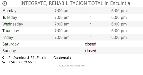
INTEGRATE, REHABILITACION TOTAL
2a.Avenida 4-81, Escuintla
Hospital
read more
37.595 km
HPG
Escuintla
Hospital
read more
39.397 km
Igss
Patulul
Hospital
read more
47.188 km
Clinic
3a Ave Yepocapa, Chimaltenango, San Pedro Yepocapa
Hospital
read more
51.731 km
Puesto De Salud
Alotenango
Hospital
read more
59.334 km
Hogar Virgen del Socorro
Guatemala
Hospital
read more
59.669 km
Retiro
Puerta Grande, Guatemala
Hospital
read more
63.361 km
National Hospital Amatitlan
7 Calle y Baŕrio hospital,, 10 Avenida, Amatitlán
Hospital
read more
63.509 km
Centro De Salud
Amatitlán
Hospital
read more
63.532 km
Hospital Santa Clara S.A.
7 Calle, Amatitlán
Hospital
read more
67.463 km
Cecomsal Mártires del Pueblo
Villa Nueva
Hospital
read more
69.505 km
Clinica La Jungla Amatitlan
Villa Nueva
Hospital
read more
69.634 km
Autonomia Igss
3—03, 11 calle, Guatemala
Hospital
read more
69.68 km
Clinica Materno Infantil Dr Saúl Ortíz
Mazatenango
Hospital
read more
69.782 km
Centro de Salud de Villa Nueva
6a. Avenida, Villa Nueva
Hospital
read more
69.801 km
Hospital Villa San Francisco
Villa Nueva
Hospital
read more
📑
all categories
Accounting
Administrative area level 1
Administrative area level 2
Airport
Amusement park
Aquarium
Art gallery
Atm
Bakery
Bank
Bar
Beauty salon
Bicycle store
Book store
Bowling alley
Bus station
Cafe
Campground
Car dealer
Car rental
Car repair
Car wash
Casino
Cemetery
Church
City hall
Clothing store
Colloquial area
Convenience store
Courthouse
Dentist
Department store
Doctor
Electrician
Electronics store
Embassy
Establishment
Finance
Fire station
Florist
Food
Funeral home
Furniture store
Gas station
General contractor
Grocery or supermarket
Gym
Hair care
Hardware store
Health
Hindu Temple
Home goods store
Hospital
Insurance agency
Jewelry store
Laundry
Lawyer
Library
Liquor store
Local government office
Locality
Locksmith
Lodging
Meal delivery
Meal takeaway
Mosque
Movie rental
Movie theater
Moving company
Museum
Natural feature
Neighborhood
Night club
Painter
Park
Parking
Pet store
Pharmacy
Physiotherapist
Place of worship
Plumber
Point of interest
Police
Political
Post office
Premise
Real estate agency
Restaurant
Route
Rv park, camping
School
Shoe store
Shopping mall
Spa
Stadium
Storage
Store
Subway station
Supermarket
Synagogue
Taxi stand
Train station
Transit station
Travel agency
University
Veterinary care
Zoo
administrative area level 3
sublocality level 1
↑