Health nearby Hospicio Santa María
Guatemala
Health nearby Hospicio Santa María
Hospicio Santa María
San Marcos Guatemala
contacts phone
:
+502
Latitude:
14.7216371
, Longitude:
-92.0573294
read more
nearest Health
9.374 km
Centro de Salud, Tecún Umán
Ayutla
Health
read more
9.374 km
Centro de Salud, Tecún Umán
Tecun Uman
Health
read more
19.856 km
Casa Hogar de ancianos Madre Teresa
1ra. calle 3-11 zona 6, Coatepeque
Health
read more
20.392 km
Banco De Sangre Coatepeque
Coatepeque
Health
read more
20.394 km
CRD del Sur
Coatepeque
Health
read more
20.446 km
Laboratorio Clinico Vida, Coatepeque
5 53, 3 Avenida, Coatepeque
Health
read more
20.568 km
Clínicas Médicas Grupo Medisur
4a Avenida, Malacatán
Health
read more
20.607 km
IGSS Enfermedad Común
Malacatán
Health
read more
20.673 km
AmorDown
IG, Coatepeque
Health
read more
20.998 km
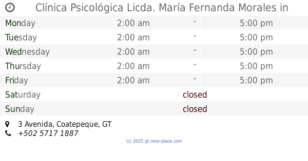
Clínica Psicológica Licda. María Fernanda Morales
8a,, 3 Avenida, Coatepeque
Health
read more
21.084 km
APROFAM
Malacatán
Health
read more
21.182 km
Optica San Jose Obrero
3a. Calle, Coatepeque
Health
read more
21.571 km
Centro Radiológico digital del Sur 3
Coatepeque
Health
read more
22.374 km
Puesto de Salud San José Petacalapa
San Jose Petacalapa
Health
read more
23.329 km
Puesto de Salud Las Brisas
Guatemala
Health
read more
38.563 km
Multi Imagenes Monte Sinai
San Marcos
Health
read more
39.761 km
GRUPO DE ALCOHOLICOS ANONIMOS
Aldea Piedra Grande
Health
read more
41.98 km
JEHOVA PROVEERA
7-51 Zona 2, San José Cáben, 2 Avenida
Health
read more
45.462 km
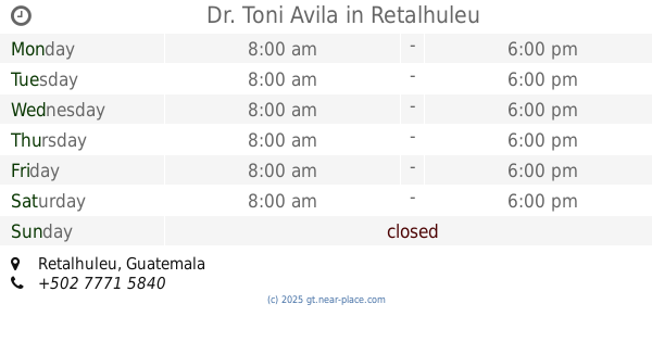
Dr. Toni Avila
Retalhuleu
Health
read more
45.51 km
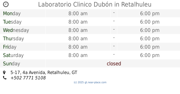
Laboratorio Clinico Dubón
4a Avenida 5-17, Retalhuleu
Health
read more
46.802 km
Clínica Médica Jehová Rafa
Retalhuleu
Health
read more
48.65 km
Puesto de Socorro el Zarco Cruz Roja Guatemalteca Delegación Retalhuleu
CA-2
Health
read more
49.987 km
Centro De Salud
San Martín Zapotitlán
Health
read more
50.873 km
Laboratorio Clínico Santa Ana
5calle zona 1, San Felipe
Health
read more
57.55 km
puesto de salud de chorjale
Quetzaltenango
Health
read more
📑
all categories
Accounting
Administrative area level 1
Administrative area level 2
Airport
Amusement park
Aquarium
Art gallery
Atm
Bakery
Bank
Bar
Beauty salon
Bicycle store
Book store
Bowling alley
Bus station
Cafe
Campground
Car dealer
Car rental
Car repair
Car wash
Casino
Cemetery
Church
City hall
Clothing store
Colloquial area
Convenience store
Courthouse
Dentist
Department store
Doctor
Electrician
Electronics store
Embassy
Establishment
Finance
Fire station
Florist
Food
Funeral home
Furniture store
Gas station
General contractor
Grocery or supermarket
Gym
Hair care
Hardware store
Health
Hindu Temple
Home goods store
Hospital
Insurance agency
Jewelry store
Laundry
Lawyer
Library
Liquor store
Local government office
Locality
Locksmith
Lodging
Meal delivery
Meal takeaway
Mosque
Movie rental
Movie theater
Moving company
Museum
Natural feature
Neighborhood
Night club
Painter
Park
Parking
Pet store
Pharmacy
Physiotherapist
Place of worship
Plumber
Point of interest
Police
Political
Post office
Premise
Real estate agency
Restaurant
Route
Rv park, camping
School
Shoe store
Shopping mall
Spa
Stadium
Storage
Store
Subway station
Supermarket
Synagogue
Taxi stand
Train station
Transit station
Travel agency
University
Veterinary care
Zoo
administrative area level 3
sublocality level 1
↑