Gym nearby guastatoya el progreso la lomita
Guatemala
Gym nearby guastatoya el progreso la lomita
guastatoya el progreso la lomita
Guastatoya Guatemala
contacts phone
:
+502
Latitude:
14.8552295
, Longitude:
-90.0707325
read more
nearest Gym
322 m
Gimnasio Apolo Gym Guastatoya
Calle Principal, Guastatoya
Gym
read more
466 m
Gimnasio Municipal
Guastatoya
Gym
read more
10.617 km
Campo de fútbol, Agua Salóbrega
Agua Salóbrega
Gym
read more
24.687 km
Campo De Futbol
El Progreso
Gym
read more
25.148 km
Sport Fitness Gym
CA-19, Jalapa
Gym
read more
25.831 km
Coliseo
Jalapa
Gym
read more
26.042 km
Templo Minerva
Jalapa
Gym
read more
26.08 km
Zumba Fitness Gym Jalapa
2 2, 1ra avenida zona 3, Jalapa
Gym
read more
30.585 km
Canchas Municipales
Cabanas
Gym
read more
32.17 km
Municipalidad
San Pedro Pinula
Gym
read more
45.67 km
Fields of Alameda
Guatemala City
Gym
read more
49.294 km
Scandinavia Gym Metro Norte Zona 17
Calzada Mariscal Zavala 00-92 11 Avenida Plaza Nororiente Anxeo Centro Comercial MetroNorte, Guatemala
Gym
read more
49.964 km
Crecer
Guatemala City
Gym
read more
52.079 km
Gym FITNESS CLUB
2da. ave. 2-43, Rabinal
Gym
read more
52.258 km
Scandinavia GYM
Guatemala City
Gym
read more
52.675 km
Campo tiro guatemala
Guatemala City
Gym
read more
53.899 km
Om Yoga Vista Hermosa
CC Metro 15, segundo Nivel, Local 212
Gym
read more
54.56 km
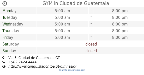
GYM
Hotel Conquistador, Via 5, Guatemala
Gym
read more
54.89 km
FitMax
Guatemala City
Gym
read more
54.995 km
Ananda Yoga Studio Guatemala
Diagonal 6 13-63 Zona 10 C.C El Porton Local 4. Frente a Papa John's, Guatemala
Gym
read more
55.638 km
Tobias Bros Academy - Parkour Tricking
Km 18.5 Carretera a El Salvador Sporta
Gym
read more
55.977 km
Om Yoga Guatemala
Design Center, Avenida 20- Centro Comercial Plaza Musical, Diagonal 6 12-42, Guatemala
Gym
read more
56.225 km
INVICTUS Performance Training
8va avenida, Guatemala
Gym
read more
56.53 km
Lotus Gym
Santa Catarina Pinula
Gym
read more
56.635 km
Futeca Sport Gym Zona 14
10 Avenida, Guatemala
Gym
read more
📑
all categories
Accounting
Administrative area level 1
Administrative area level 2
Airport
Amusement park
Aquarium
Art gallery
Atm
Bakery
Bank
Bar
Beauty salon
Bicycle store
Book store
Bowling alley
Bus station
Cafe
Campground
Car dealer
Car rental
Car repair
Car wash
Casino
Cemetery
Church
City hall
Clothing store
Colloquial area
Convenience store
Courthouse
Dentist
Department store
Doctor
Electrician
Electronics store
Embassy
Establishment
Finance
Fire station
Florist
Food
Funeral home
Furniture store
Gas station
General contractor
Grocery or supermarket
Gym
Hair care
Hardware store
Health
Hindu Temple
Home goods store
Hospital
Insurance agency
Jewelry store
Laundry
Lawyer
Library
Liquor store
Local government office
Locality
Locksmith
Lodging
Meal delivery
Meal takeaway
Mosque
Movie rental
Movie theater
Moving company
Museum
Natural feature
Neighborhood
Night club
Painter
Park
Parking
Pet store
Pharmacy
Physiotherapist
Place of worship
Plumber
Point of interest
Police
Political
Post office
Premise
Real estate agency
Restaurant
Route
Rv park, camping
School
Shoe store
Shopping mall
Spa
Stadium
Storage
Store
Subway station
Supermarket
Synagogue
Taxi stand
Train station
Transit station
Travel agency
University
Veterinary care
Zoo
administrative area level 3
sublocality level 1
↑