Gas station nearby Gasolinera
Guatemala
Gas station nearby Gasolinera
Gasolinera
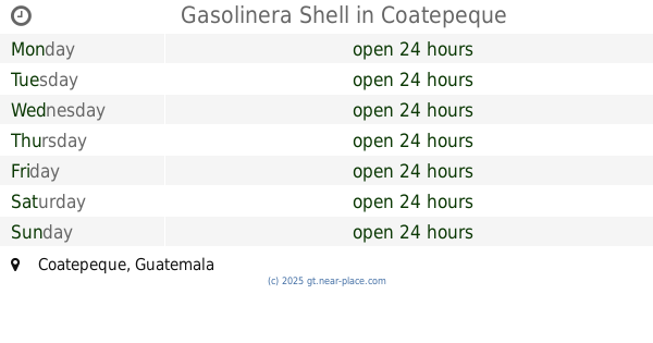
Coatepeque, Guatemala
contacts phone
:
+502
Latitude:
14.6983517
, Longitude:
-91.8642623
larger map & directions
read more
nearest Gas station
317 m
Texaco Coatepeque
Avenida 20 de Octubre, Coatepeque
Gas station
read more
317 m
Texaco
Avenida 20 de Octubre, Coatepeque
Gas station
read more
647 m
Gasolinera Shell
Coatepeque
Gas station
read more
647 m
Shell
Coatepeque
Gas station
read more
709 m
Gasolinera Puma
Coatepeque
Gas station
read more
709 m
Estacion Chuatuj
Coatepeque
Gas station
read more
794 m
Gasolinera Texaco
9a. Calle, Coatepeque
Gas station
read more
1.032 km
Estacion Coatepeque
Coatepeque
Gas station
read more
1.07 km
Santa Lucia
Coatepeque
Gas station
read more
1.878 km
Shell
7a. Calle, Coatepeque
Gas station
read more
1.878 km
Estacion shell Coatepeque
7a. Calle, Coatepeque
Gas station
read more
2.689 km
Gasolinera Energy Max Coatepeque
Quezaltenango
Gas station
read more
2.689 km
Gasolinera Energy Max Coatepeque
Quetzaltenango
Gas station
read more
4.947 km
San Cristobal Gas
CA-2
Gas station
read more
4.947 km
Gas San Cristobal
CA-2
Gas station
read more
5.157 km
Gasolinera Shell
La Unión
Gas station
read more
5.157 km
Shell
La Unión
Gas station
read more
5.472 km
Estacion Costa Cuca
CA-2
Gas station
read more
6.947 km
Gasolinera El Manantial
Flores Costa Cuca
Gas station
read more
9.765 km
Gasolinera San Rafael
San Rafael Pacayá
Gas station
read more
15.713 km
Gasolinera Xab
CA-2
Gas station
read more
18.106 km
Gasolinera Stop
Nahuatan
Gas station
read more
18.478 km
Gasolinera Carolinas 2
Calle principal, El Asintal
Gas station
read more
19.536 km
Carolinas Santa Elena
CA-2
Gas station
read more
20.891 km
Smart Gas
CA-2
Gas station
read more
📑
all categories
Accounting
Administrative area level 1
Administrative area level 2
Airport
Amusement park
Aquarium
Art gallery
Atm
Bakery
Bank
Bar
Beauty salon
Bicycle store
Book store
Bowling alley
Bus station
Cafe
Campground
Car dealer
Car rental
Car repair
Car wash
Casino
Cemetery
Church
City hall
Clothing store
Colloquial area
Convenience store
Courthouse
Dentist
Department store
Doctor
Electrician
Electronics store
Embassy
Establishment
Finance
Fire station
Florist
Food
Funeral home
Furniture store
Gas station
General contractor
Grocery or supermarket
Gym
Hair care
Hardware store
Health
Hindu Temple
Home goods store
Hospital
Insurance agency
Jewelry store
Laundry
Lawyer
Library
Liquor store
Local government office
Locality
Locksmith
Lodging
Meal delivery
Meal takeaway
Mosque
Movie rental
Movie theater
Moving company
Museum
Natural feature
Neighborhood
Night club
Painter
Park
Parking
Pet store
Pharmacy
Physiotherapist
Place of worship
Plumber
Point of interest
Police
Political
Post office
Premise
Real estate agency
Restaurant
Route
Rv park, camping
School
Shoe store
Shopping mall
Spa
Stadium
Storage
Store
Subway station
Supermarket
Synagogue
Taxi stand
Train station
Transit station
Travel agency
University
Veterinary care
Zoo
administrative area level 3
sublocality level 1
↑