Establishment nearby Medicina y Primeros Auxilios
Guatemala
Establishment nearby Medicina y Primeros Auxilios
Medicina y Primeros Auxilios
San Joaquín, Guatemala
contacts phone
:
+502
Latitude:
16.9187457
, Longitude:
-90.2537664
larger map & directions
read more
nearest Establishment
255 m
Comedor El Arca
San Joaquín, La Libertad
Cafe
Food
Point of interest
Establishment
read more
911 m
Taquería Doña Tana
San Joaquín, La Libertad
Cafe
Food
Point of interest
Establishment
read more
982 m
Puesto de Salud San Joaquín
San Joaquín, La Libertad
Hospital
Health
Point of interest
Establishment
read more
4.93 km
Unicomer Gonzalez
WP62+R57, Guatemala
Supermarket
Grocery or supermarket
Food
Point of interest
Store
Establishment
read more
4.93 km
Walmart
Guatemala
Supermarket
Grocery or supermarket
Food
Point of interest
Store
Establishment
read more
4.97 km
Clínica Dental
Calle Principal, Barrio el Paraíso
Dentist
Health
Point of interest
Establishment
read more
19.058 km
Poli
QVWC+576, La Libertad
Cafe
Food
Point of interest
Store
Establishment
read more
19.358 km
Restaurante EL CORRAL
RD-PET-13, La Libertad
Restaurant
Food
Point of interest
Establishment
read more
19.552 km
Hotel y Antojitos Villa Real
RD-PET-13, La Libertad
Restaurant
Food
Point of interest
Establishment
read more
20.073 km
Cervefrio libertad
RD-PET-13, La Libertad
Supermarket
Grocery or supermarket
Food
Point of interest
Store
Establishment
read more
20.284 km
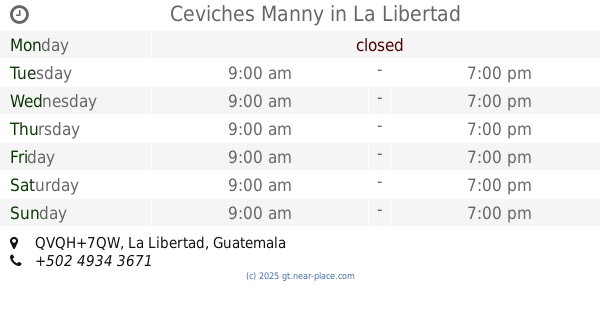
Ceviches Manny
QVQH+7QW, La Libertad
Restaurant
Food
Point of interest
Establishment
read more
20.294 km
RESTAURANTE LAS FLORES
RD-PET-13, La Libertad
Restaurant
Food
Point of interest
Establishment
read more
20.327 km
Antojitos para su paladar
Avenida Antonio Sanchez, Barrio El Centro
Restaurant
Food
Point of interest
Establishment
read more
20.48 km
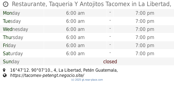
Restaurante, Taqueria Y Antojitos Tacomex
16°47'12. 90°07'10., 4, La Libertad, Petén Guatemala
Restaurant
Cafe
Food
Point of interest
Store
Establishment
read more
20.487 km
Comedor El Tucan
QVPJ+P65, La Libertad
Restaurant
Food
Point of interest
Establishment
read more
20.503 km
Pocho's y pocha's
RD-PET-13, La Libertad
Restaurant
Food
Point of interest
Establishment
read more
20.521 km
HOTEL PLAZA
QVQJ+6X6, La Libertad
Lodging
Point of interest
Establishment
read more
20.538 km
Variedades Emanuel
QVPJ+PG3, La Libertad
Supermarket
Grocery or supermarket
Food
Point of interest
Store
Establishment
read more
20.548 km
Yelena Restaurant El Buen Sazón
Colegio Guadalupano, A un costado del mercado nuevo, calle que conduce al, La Libertad
Restaurant
Food
Point of interest
Establishment
read more
20.584 km
Campo los pinos
Primera, La Libertad
Lodging
Point of interest
Establishment
read more
20.602 km
Iglesia Camino Bíblico
QVMH+JPJ, La Libertad
Lodging
Point of interest
Establishment
read more
20.709 km
Despensa Familiar
PET-13, La Libertad
Supermarket
Grocery or supermarket
Food
Point of interest
Store
Establishment
read more
20.733 km
Hotel Oriental
La Libertad
Lodging
Point of interest
Establishment
read more
20.754 km
benta de tacos michuacan
QVPM+QP8, La Libertad
Restaurant
Food
Point of interest
Establishment
read more
20.935 km
Trabajo Banco Azteca
QVPP+QM4, La Libertad
Bank
Finance
Point of interest
Establishment
read more
📑
all categories
Accounting
Administrative area level 1
Administrative area level 2
Airport
Amusement park
Aquarium
Art gallery
Atm
Bakery
Bank
Bar
Beauty salon
Bicycle store
Book store
Bowling alley
Bus station
Cafe
Campground
Car dealer
Car rental
Car repair
Car wash
Casino
Cemetery
Church
City hall
Clothing store
Colloquial area
Convenience store
Courthouse
Dentist
Department store
Doctor
Electrician
Electronics store
Embassy
Establishment
Finance
Fire station
Florist
Food
Funeral home
Furniture store
Gas station
General contractor
Grocery or supermarket
Gym
Hair care
Hardware store
Health
Hindu Temple
Home goods store
Hospital
Insurance agency
Jewelry store
Laundry
Lawyer
Library
Liquor store
Local government office
Locality
Locksmith
Lodging
Meal delivery
Meal takeaway
Mosque
Movie rental
Movie theater
Moving company
Museum
Natural feature
Neighborhood
Night club
Painter
Park
Parking
Pet store
Pharmacy
Physiotherapist
Place of worship
Plumber
Point of interest
Police
Political
Post office
Premise
Real estate agency
Restaurant
Route
Rv park, camping
School
Shoe store
Shopping mall
Spa
Stadium
Storage
Store
Subway station
Supermarket
Synagogue
Taxi stand
Train station
Transit station
Travel agency
University
Veterinary care
Zoo
administrative area level 3
sublocality level 1
↑