Church nearby Iglesia De Jesucristo SUD (Barrio Cobán 2)
Guatemala
Church nearby Iglesia De Jesucristo SUD (Barrio Cobán 2)
Iglesia De Jesucristo SUD (Barrio Cobán 2)
Cobán Guatemala
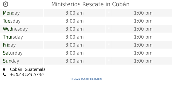
contacts phone
:
+502
Latitude:
15.4596886
, Longitude:
-90.3655321
read more
nearest Church
62 m
Verbo
1a Avenida, Cobán
Church
read more
377 m
Fransisco Javier
Cobán
Church
read more
740 m
Palabra Miel Coban
Cobán
Church
read more
872 m
AUDITORIUM Iglesia De Dios Nueva Jerusalem
1-48 lotificacion W, Coban A.V., 8a Avenida 3, Cobán
Church
read more
1000 m
Iglesia Cristiana Zered
Barrio Yalguo, Cobán
Church
read more
1.114 km
Salón Hnas. Benedictinas
7a Avenida, Cobán
Church
read more
1.174 km
IGLESIA DE CRISTO EBENEZER COBÁN
1a Avenida, Cobán
Church
read more
1.273 km
Iglesia Peña De Horeb
Cobán
Church
read more
1.353 km
Iglesia Adventista Del Septimo Día
Cobán
Church
read more
1.397 km
Diócesis de La Verapaz
Cobán
Church
read more
1.411 km
Parroquia Santo Domingo de Guzmán
Cobán
Church
read more
1.411 km
Catedral Santo Domingo de Coban
Cobán
Church
read more
1.438 km
Iglesia de Cristo ELOHIM
6a Avenida, Cobán
Church
read more
1.447 km
Iglesia De Jesucristo SUD Barrio 3 (Centro De Estaca)
Cobán
Church
read more
1.47 km
Parroquia San Marcos
9a Avenida, Cobán
Church
read more
1.537 km
Iglesia del Nazareno Queqchi
Zona 4
Church
read more
1.757 km
Iglesia Chi Ixim
Tactic
Church
read more
1.784 km
Ministerios Rescate
Cobán
Church
read more
1.877 km
Parroquia San Martín de Porres
Zona 2
Church
read more
1.923 km
La Puerta de Las Ovejas
Cobán
Church
read more
1.942 km
Parroquia San Martín De Porres
Cobán
Church
read more
2 km
MISIÓN CRISTIANA EL CALVARIO COBAN
Cobán
Church
read more
2.092 km
Capilla de La Ermita de Santo Domingo Guzman
Cobán
Church
read more
2.124 km
El Calvario
Cobán
Church
read more
2.13 km
Capilla El Calvario
Cobán
Church
read more
📑
all categories
Accounting
Administrative area level 1
Administrative area level 2
Airport
Amusement park
Aquarium
Art gallery
Atm
Bakery
Bank
Bar
Beauty salon
Bicycle store
Book store
Bowling alley
Bus station
Cafe
Campground
Car dealer
Car rental
Car repair
Car wash
Casino
Cemetery
Church
City hall
Clothing store
Colloquial area
Convenience store
Courthouse
Dentist
Department store
Doctor
Electrician
Electronics store
Embassy
Establishment
Finance
Fire station
Florist
Food
Funeral home
Furniture store
Gas station
General contractor
Grocery or supermarket
Gym
Hair care
Hardware store
Health
Hindu Temple
Home goods store
Hospital
Insurance agency
Jewelry store
Laundry
Lawyer
Library
Liquor store
Local government office
Locality
Locksmith
Lodging
Meal delivery
Meal takeaway
Mosque
Movie rental
Movie theater
Moving company
Museum
Natural feature
Neighborhood
Night club
Painter
Park
Parking
Pet store
Pharmacy
Physiotherapist
Place of worship
Plumber
Point of interest
Police
Political
Post office
Premise
Real estate agency
Restaurant
Route
Rv park, camping
School
Shoe store
Shopping mall
Spa
Stadium
Storage
Store
Subway station
Supermarket
Synagogue
Taxi stand
Train station
Transit station
Travel agency
University
Veterinary care
Zoo
administrative area level 3
sublocality level 1
↑