Church nearby Iglesia Cristo De Esquipulas, Esfuerzo 1.
Guatemala
Church nearby Iglesia Cristo De Esquipulas, Esfuerzo 1.
Iglesia Cristo De Esquipulas, Esfuerzo 1.
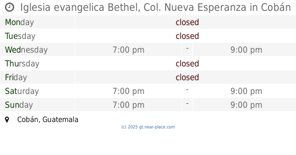
Cobán, Guatemala
contacts phone
:
+502
Latitude:
15.4661617
, Longitude:
-90.3994812
larger map & directions
read more
nearest Church
185 m
Iglesia Asamblea De Dios Alfa Y Omega
Unnamed Road, Cobán
Church
read more
321 m
La Iglesia de Jesucristo de los Santos de los Ultimos Dias, Los Campos
Cobán
Church
read more
430 m
Iglesia Testigos de Jehova
Cobán
Church
read more
686 m
Iglesia Adventista Sachamach
Cobán
Church
read more
818 m
La Iglesia de Dios de la Profecia "Cobán"
Cobán
Church
read more
833 m
Iglesia Nueva Esperanza
Cobán
Church
read more
853 m
Iglesia evangelica Bethel, Col. Nueva Esperanza
Cobán
Church
read more
860 m
MISIONERAS DOMINICAS DEL ROSARIO COBAN
Cobán
Church
read more
877 m
Iglesia Del Nazareno
Cobán
Church
read more
881 m
La Puerta de las Ovejas Petet
Cobán
Church
read more
954 m
Iglesia de Cristo Manantial de Vida de Cobán
Cobán
Church
read more
1.058 km
Iglesia Católica
Cobán
Church
read more
1.254 km
Asamblea De Dios Lirio De Los Valles
Cobán
Church
read more
1.508 km
Iglesia de Dios El Remanente
Cobán
Church
read more
1.717 km
De la Comunidad
Cobán
Church
read more
1.895 km
iglesia Asamblea De Dios Alfa Y Omega
Alta Verapaz
Church
read more
1.952 km
La Puerta de Las Ovejas
Cobán
Church
read more
1.998 km
Iglesia De Dios E.C. Aposento Alto
Cobán
Church
read more
2.204 km
Parroquia San Martín de Porres
Zona 2
Church
read more
2.467 km
Capilla El Calvario
Cobán
Church
read more
2.766 km
Iglesia Peña De Horeb
Cobán
Church
read more
2.772 km
IGLESIA DE CRISTO EBENEZER COBÁN
1a Avenida, Cobán
Church
read more
2.873 km
Diócesis de La Verapaz
Cobán
Church
read more
2.889 km
Catedral Santo Domingo de Coban
Cobán
Church
read more
2.889 km
Parroquia Santo Domingo de Guzmán
Cobán
Church
read more
📑
all categories
Accounting
Administrative area level 1
Administrative area level 2
Airport
Amusement park
Aquarium
Art gallery
Atm
Bakery
Bank
Bar
Beauty salon
Bicycle store
Book store
Bowling alley
Bus station
Cafe
Campground
Car dealer
Car rental
Car repair
Car wash
Casino
Cemetery
Church
City hall
Clothing store
Colloquial area
Convenience store
Courthouse
Dentist
Department store
Doctor
Electrician
Electronics store
Embassy
Establishment
Finance
Fire station
Florist
Food
Funeral home
Furniture store
Gas station
General contractor
Grocery or supermarket
Gym
Hair care
Hardware store
Health
Hindu Temple
Home goods store
Hospital
Insurance agency
Jewelry store
Laundry
Lawyer
Library
Liquor store
Local government office
Locality
Locksmith
Lodging
Meal delivery
Meal takeaway
Mosque
Movie rental
Movie theater
Moving company
Museum
Natural feature
Neighborhood
Night club
Painter
Park
Parking
Pet store
Pharmacy
Physiotherapist
Place of worship
Plumber
Point of interest
Police
Political
Post office
Premise
Real estate agency
Restaurant
Route
Rv park, camping
School
Shoe store
Shopping mall
Spa
Stadium
Storage
Store
Subway station
Supermarket
Synagogue
Taxi stand
Train station
Transit station
Travel agency
University
Veterinary care
Zoo
administrative area level 3
sublocality level 1
↑