Cemetery nearby Cementerio Municipal
Guatemala
Cemetery nearby Cementerio Municipal
Cementerio Municipal
Concepción Las Minas Guatemala
contacts phone
:
+502
Latitude:
14.5256026
, Longitude:
-89.4563007
read more
nearest Cemetery
9.895 km
Cementerio De Cacahuatepeque
Chiquimula
Cemetery
read more
11.946 km
Cementerio General Esquipulas
Esquipulas
Cemetery
read more
11.985 km
Cementerio General
Esquipulas
Cemetery
read more
12.154 km
Cementerio General De Quezaltepeque
Quezaltepeque
Cemetery
read more
12.183 km
Antiguo Cementerio General
Quezaltepeque
Cemetery
read more
12.602 km
Camposanto Los Milagros
Esquipulas
Cemetery
read more
12.892 km
CEMETERY ENTRY Crucitas
Esquipulas
Cemetery
read more
12.892 km
ENTRADA CEMENTERIO LAS CRUCITAS
Esquipulas
Cemetery
read more
12.995 km
Cementerio Las Crucitas
Esquipulas
Cemetery
read more
16.669 km
Cementerio San Jacinto
San Jacinto
Cemetery
read more
20.905 km
Cementerio General
Aldea Santa Elena
Cemetery
read more
20.991 km
Cementerio Municipal de Ipala
Ipala
Cemetery
read more
21.032 km
Cementerio General
Ipala
Cemetery
read more
21.052 km
Cementerio Ipala
Ipala
Cemetery
read more
23.258 km
Cementerio Municipal
Agua Blanca
Cemetery
read more
26.04 km
Cementerio Municipal
San Jose La Arada
Cemetery
read more
31.394 km
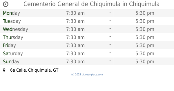
Cementerio General de Chiquimula
6a Calle, Chiquimula
Cemetery
read more
35.476 km
Asuncion Mita Cemetery
Asunción Mita
Cemetery
read more
37.35 km
Cementerio Local "El Copalito"
Los Horcones
Cemetery
read more
40.762 km
Cementerio Comunal Trapiche Abajo
Trapiche Abajo
Cemetery
read more
45.844 km
Cementerio Comunal Santa Rosalía
Santa Rosalía
Cemetery
read more
49.371 km
Cementerio Rinconada
Guatemala
Cemetery
read more
52.21 km
Cementerio Jicaro Grande
Jutiapa
Cemetery
read more
58.525 km
Cementerio municipal
Usumatlan
Cemetery
read more
58.674 km
Cementerio Municipal Cabañas, Zacapa
Cabanas
Cemetery
read more
📑
all categories
Accounting
Administrative area level 1
Administrative area level 2
Airport
Amusement park
Aquarium
Art gallery
Atm
Bakery
Bank
Bar
Beauty salon
Bicycle store
Book store
Bowling alley
Bus station
Cafe
Campground
Car dealer
Car rental
Car repair
Car wash
Casino
Cemetery
Church
City hall
Clothing store
Colloquial area
Convenience store
Courthouse
Dentist
Department store
Doctor
Electrician
Electronics store
Embassy
Establishment
Finance
Fire station
Florist
Food
Funeral home
Furniture store
Gas station
General contractor
Grocery or supermarket
Gym
Hair care
Hardware store
Health
Hindu Temple
Home goods store
Hospital
Insurance agency
Jewelry store
Laundry
Lawyer
Library
Liquor store
Local government office
Locality
Locksmith
Lodging
Meal delivery
Meal takeaway
Mosque
Movie rental
Movie theater
Moving company
Museum
Natural feature
Neighborhood
Night club
Painter
Park
Parking
Pet store
Pharmacy
Physiotherapist
Place of worship
Plumber
Point of interest
Police
Political
Post office
Premise
Real estate agency
Restaurant
Route
Rv park, camping
School
Shoe store
Shopping mall
Spa
Stadium
Storage
Store
Subway station
Supermarket
Synagogue
Taxi stand
Train station
Transit station
Travel agency
University
Veterinary care
Zoo
administrative area level 3
sublocality level 1
↑