Cafe nearby santa clara
Guatemala
Cafe nearby santa clara
santa clara
20 Calle, Guatemala Guatemala
contacts phone
:
+502
Latitude:
14.5873525
, Longitude:
-90.50392
read more
nearest Cafe
324 m
Mint
18 Avenida, Guatemala
Cafe
read more
338 m
Cafetería La Morenita
Guatemala City
Cafe
read more
528 m
La K-fe De Benjamín
Guatemala City
Cafe
read more
528 m
La K-fe De Benjamín
Guatemala
Cafe
read more
739 m
Torre Verona corp. Victoria
Guatemala City
Cafe
read more
739 m
Torre Verona corp. Victoria
Guatemala
Cafe
read more
748 m
& Cafe Centro Comercial Prisa
Guatemala
Cafe
read more
754 m
& Cafe
Guatemala City
Cafe
read more
820 m
CAFE EL MONAGUITO
9A Avenida, Guatemala
Cafe
read more
822 m
Pan Komido
Colonia Oakland, Guatemala City
Cafe
read more
822 m
Pan Komido
Colonia Oakland, Guatemala
Cafe
read more
858 m
Coffee Bar Delfines
Guatemala
Cafe
read more
968 m
Casalini de Altamira
Guatemala City
Cafe
read more
1.014 km
El Parisino
6a Avenida 20-42 zona 10 Centro Comercial Plaza Musical, Guatemala
Cafe
read more
1.046 km
Santos Coffee Shop
Guatemala City
Cafe
read more
1.046 km
Santos Café
Guatemala
Cafe
read more
1.072 km
Culinaria
Boulevard los Proceres, Ciudad de Guatemala
Cafe
Food
Point of interest
Establishment
read more
1.079 km
Gitane Nearsol
Guatemala City
Cafe
read more
1.079 km
Gitane Nearsol
Guatemala
Cafe
read more
1.124 km
Culinaria
Boulevar Los Proceres, Guatemala
Cafe
read more
1.146 km
El Cafetalito Rambla10
Guatemala
Cafe
read more
1.146 km
El Cafetalito Rambla10
Guatemala City
Cafe
read more
1.167 km
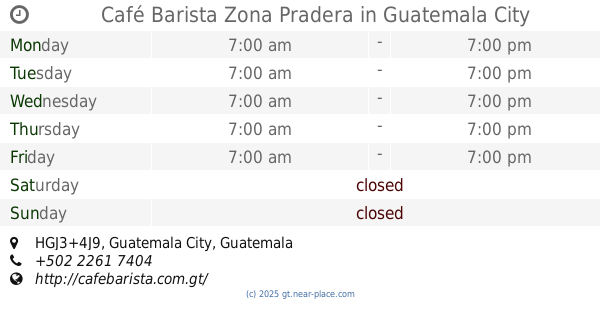
Café Barista Zona Pradera
HGJ3+4J9, Guatemala City
Cafe
Food
Point of interest
Establishment
read more
1.273 km
El Cafetalito CC Pradera Zona 10
19 Calle 25-85, Guatemala
Cafe
read more
1.3 km
Café Barista La Pradera.
Interamerican Highway 18, Guatemala
Cafe
read more
📑
all categories
Accounting
Administrative area level 1
Administrative area level 2
Airport
Amusement park
Aquarium
Art gallery
Atm
Bakery
Bank
Bar
Beauty salon
Bicycle store
Book store
Bowling alley
Bus station
Cafe
Campground
Car dealer
Car rental
Car repair
Car wash
Casino
Cemetery
Church
City hall
Clothing store
Colloquial area
Convenience store
Courthouse
Dentist
Department store
Doctor
Electrician
Electronics store
Embassy
Establishment
Finance
Fire station
Florist
Food
Funeral home
Furniture store
Gas station
General contractor
Grocery or supermarket
Gym
Hair care
Hardware store
Health
Hindu Temple
Home goods store
Hospital
Insurance agency
Jewelry store
Laundry
Lawyer
Library
Liquor store
Local government office
Locality
Locksmith
Lodging
Meal delivery
Meal takeaway
Mosque
Movie rental
Movie theater
Moving company
Museum
Natural feature
Neighborhood
Night club
Painter
Park
Parking
Pet store
Pharmacy
Physiotherapist
Place of worship
Plumber
Point of interest
Police
Political
Post office
Premise
Real estate agency
Restaurant
Route
Rv park, camping
School
Shoe store
Shopping mall
Spa
Stadium
Storage
Store
Subway station
Supermarket
Synagogue
Taxi stand
Train station
Transit station
Travel agency
University
Veterinary care
Zoo
administrative area level 3
sublocality level 1
↑