Cafe nearby Mi Cafe Y Comedor La Esperanza
Guatemala
Cafe nearby Mi Cafe Y Comedor La Esperanza
Mi Cafe Y Comedor La Esperanza
El Nuevo Palmar Guatemala
contacts phone
:
+502
Latitude:
14.6449868
, Longitude:
-91.5583651
read more
nearest Cafe
825 m
Mi Cafe La Esperanza
Retalhuleu
Cafe
read more
4.398 km
Pecos Bill
San Felipe
Cafe
read more
4.748 km
Licuados Kathia
San Felipe
Cafe
read more
4.833 km
Churrasquitos y Panitos
San Felipe
Cafe
read more
7.06 km
Finca SANTA ANITA ZUNILITO
Zunilito
Cafe
read more
7.344 km
MIA CAFE, Lo Hacemos De Corazon...
3ra calle, San Francisco Zapotitlán
Cafe
read more
7.36 km
Cafetería Love Coffee
Unnamed Road, San Francisco Zapotitlán
Cafe
read more
9.417 km
Sununches 2, San Andres Villa Seca, Retalulehu
Unnamed Road, San Andrés Villa Seca
Cafe
read more
12.75 km
Comedor Amado
Quetzaltenango
Cafe
read more
13.177 km
Antojitos Batanecos Yoli
5a Avenida, San Sebastian
Cafe
read more
13.47 km
Cafeteria Jabes
Mazatenango
Cafe
read more
13.5 km
Mi Cafe San Sebastian
San Sebastian
Cafe
read more
13.63 km
Candy Ice
Mazatenango
Cafe
read more
13.973 km
Autocafe Barista
CA-2, Mazatenango
Cafe
read more
14.328 km
Real Snacks El Rincon De Los Antojitos
3 calle 0-27 z.3 Barrio san Benito
Cafe
read more
15.674 km
ANTOJITOS
San Bernardino
Cafe
read more
15.854 km
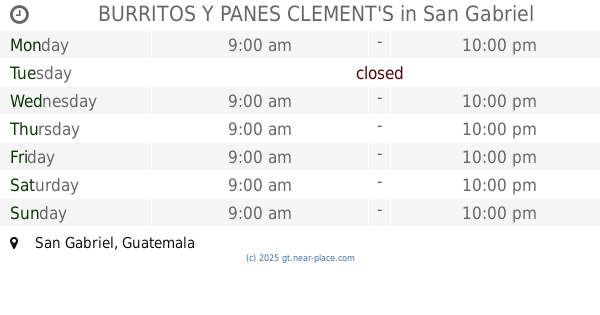
BURRITOS Y PANES CLEMENT'S
San Gabriel
Cafe
read more
17.148 km
Cholados Reu
11 Calle, Retalhuleu
Cafe
read more
17.414 km
shucos
Retalhuleu
Cafe
read more
17.67 km
CAFE KIUT'Z
9 ave. 5-39, Retalhuleu
Cafe
read more
18.158 km
Pastelería Doña Trinis
Retalhuleu
Cafe
read more
18.175 km
London Cafe
Retalhuleu
Cafe
read more
18.316 km
Cafe BARISTA
Entrada a La Trinidad, Retalhuleu
Cafe
read more
18.32 km
Pastelería Doña Trinis 3
Retalhuleu
Cafe
read more
19.163 km
El Parce
Retalhuleu
Cafe
read more
📑
all categories
Accounting
Administrative area level 1
Administrative area level 2
Airport
Amusement park
Aquarium
Art gallery
Atm
Bakery
Bank
Bar
Beauty salon
Bicycle store
Book store
Bowling alley
Bus station
Cafe
Campground
Car dealer
Car rental
Car repair
Car wash
Casino
Cemetery
Church
City hall
Clothing store
Colloquial area
Convenience store
Courthouse
Dentist
Department store
Doctor
Electrician
Electronics store
Embassy
Establishment
Finance
Fire station
Florist
Food
Funeral home
Furniture store
Gas station
General contractor
Grocery or supermarket
Gym
Hair care
Hardware store
Health
Hindu Temple
Home goods store
Hospital
Insurance agency
Jewelry store
Laundry
Lawyer
Library
Liquor store
Local government office
Locality
Locksmith
Lodging
Meal delivery
Meal takeaway
Mosque
Movie rental
Movie theater
Moving company
Museum
Natural feature
Neighborhood
Night club
Painter
Park
Parking
Pet store
Pharmacy
Physiotherapist
Place of worship
Plumber
Point of interest
Police
Political
Post office
Premise
Real estate agency
Restaurant
Route
Rv park, camping
School
Shoe store
Shopping mall
Spa
Stadium
Storage
Store
Subway station
Supermarket
Synagogue
Taxi stand
Train station
Transit station
Travel agency
University
Veterinary care
Zoo
administrative area level 3
sublocality level 1
↑