Cafe nearby Atolito y Tostadas Cristy
Guatemala
Cafe nearby Atolito y Tostadas Cristy
Atolito y Tostadas Cristy
33 Avenida, Guatemala, GT Guatemala
contacts phone
:
+502 6549 8732
Latitude:
14.5401071
, Longitude:
-90.536183
larger map & directions
read more
nearest Cafe
1.219 km
Patsy
Boca del Monte
Cafe
read more
1.219 km
Patsy
GFWC+VXV
Cafe
Food
Point of interest
Establishment
read more
1.363 km
El Cafetalito
5A Calle, Guatemala
Cafe
read more
1.556 km
Pasteleria Ferdy's
5A Calle, Guatemala
Cafe
read more
1.79 km
TERI CAFE
Local R3, Carretera a Villa Canales km. 15.5
Cafe
read more
2.297 km
Tortillería Gigante TORTIAMIGOS
Calle Real de Petapa
Cafe
read more
2.807 km
Al Paso Comedor
Guatemala
Cafe
read more
2.807 km
Al Paso Dining
Guatemala City
Cafe
read more
2.983 km
Deli Nice
Guatemala City
Cafe
read more
2.983 km
Deli Nice
Guatemala
Cafe
read more
3.196 km
Electro Motriz Payes
Guatemala City
Cafe
read more
4.507 km
Gitane Genpact
Colonia San Carlos, Guatemala City
Cafe
read more
4.682 km
Café Gitane
15 Avenida 18, Guatemala
Cafe
read more
4.831 km
Café Despierto
Guatemala
Cafe
read more
5.06 km
la casa del shuko
Villa Nueva
Cafe
read more
5.098 km
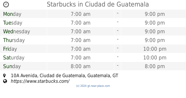
Starbucks
10A Avenida, Ciudad de Guatemala
Cafe
Food
Point of interest
Store
Establishment
read more
5.346 km
Cafe Barista
Villa Nueva
Cafe
read more
5.697 km
Coffee Bar Delfines
Guatemala
Cafe
read more
6.278 km
Café Barista La Pradera.
Interamerican Highway 18, Guatemala
Cafe
read more
6.295 km
El Cafetalito Rambla10
Guatemala
Cafe
read more
6.295 km
El Cafetalito Rambla10
Guatemala City
Cafe
read more
6.392 km
Stella's Café
Guatemala
Cafe
read more
6.408 km
Muriel Café Arkadia
Arkadia Shopping, Guatemala
Cafe
read more
6.435 km
Muriel Postres Gourmet
Colonia Alcazar, Guatemala City
Cafe
read more
6.487 km
Addic Tea Arkadia
Guatemala City
Cafe
read more
📑
all categories
Accounting
Administrative area level 1
Administrative area level 2
Airport
Amusement park
Aquarium
Art gallery
Atm
Bakery
Bank
Bar
Beauty salon
Bicycle store
Book store
Bowling alley
Bus station
Cafe
Campground
Car dealer
Car rental
Car repair
Car wash
Casino
Cemetery
Church
City hall
Clothing store
Colloquial area
Convenience store
Courthouse
Dentist
Department store
Doctor
Electrician
Electronics store
Embassy
Establishment
Finance
Fire station
Florist
Food
Funeral home
Furniture store
Gas station
General contractor
Grocery or supermarket
Gym
Hair care
Hardware store
Health
Hindu Temple
Home goods store
Hospital
Insurance agency
Jewelry store
Laundry
Lawyer
Library
Liquor store
Local government office
Locality
Locksmith
Lodging
Meal delivery
Meal takeaway
Mosque
Movie rental
Movie theater
Moving company
Museum
Natural feature
Neighborhood
Night club
Painter
Park
Parking
Pet store
Pharmacy
Physiotherapist
Place of worship
Plumber
Point of interest
Police
Political
Post office
Premise
Real estate agency
Restaurant
Route
Rv park, camping
School
Shoe store
Shopping mall
Spa
Stadium
Storage
Store
Subway station
Supermarket
Synagogue
Taxi stand
Train station
Transit station
Travel agency
University
Veterinary care
Zoo
administrative area level 3
sublocality level 1
↑