Cafe nearby Antojitos Lilas
Guatemala
Cafe nearby Antojitos Lilas
Antojitos Lilas
4 Calle, Escuintla, GT Guatemala
contacts phone
:
+502
Latitude:
14.3047697
, Longitude:
-90.7854135
larger map & directions
read more
nearest Cafe
338 m
Pan y Frutas
4a. Avenida Mercado, Escuintla
Cafe
read more
379 m
Cafe San Luxas
2a.Avenida, Escuintla
Cafe
read more
382 m
El CAFETAL COFEE SHOP
Escuintla
Cafe
read more
467 m
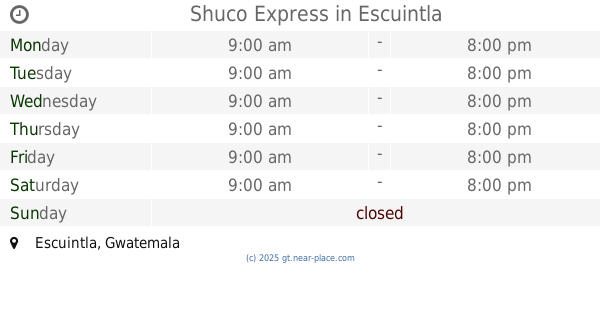
Shuco Express
Escuintla
Cafe
read more
774 m
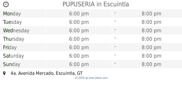
PUPUSERIA
4a. Avenida Mercado, Escuintla
Cafe
read more
1.148 km
Pasteleria Los Chapincitos
Escuintla
Cafe
read more
1.439 km
Panes Fredy
Escuintla
Cafe
read more
1.832 km
Cafe Barista
Escuintla
Cafe
read more
3.031 km
EL REFUERZO TCC
Unnamed Road
Cafe
read more
6.235 km
SERVIAL I
Carretera CA-9
Cafe
read more
14.596 km
Dreams Coffee
3ra calle 0-50, Palín
Cafe
read more
14.596 km
Dreams Coffe
3ra calle 0-50, Palín
Cafe
read more
14.64 km
K-fé San Lucas
Profesor Marcelino Nicolas Moscut, 5ta. Calle 15, 2 Calle, San Juan Sacatepéquez
Cafe
read more
15.157 km
Blopetsa Planta II
C845+CFW, Palin
Cafe
Food
Point of interest
Establishment
read more
17.886 km
Olam
Guatemala
Cafe
read more
20.317 km
Fca. El Milagro
Guatemala
Cafe
read more
23.938 km
1 Abastesimiento
14, Escuintla
Cafe
read more
24.48 km
Cafeteria Amabil
San Miguel Dueñas
Cafe
read more
24.535 km
502 Coffee Shop
4ta calle 3-24 zona 4, Ciudad Vieja
Cafe
read more
26.068 km
Amati Coffee Web
9, 4ta avenida, Amatitlán
Cafe
read more
26.181 km
Arte Caffe
7-95, 4 Avenida, Amatitlán
Cafe
read more
28.522 km
Internet AS-TIC
Yepocapa
Cafe
read more
28.522 km
Internet AS-TIC
San Pedro Yepocapa
Cafe
read more
28.7 km
Ciber World
San Francisco Road, San Pedro Yepocapa
Cafe
read more
30.054 km
Comedor Las Longanizas
3 Calle, Villa Nueva
Cafe
read more
📑
all categories
Accounting
Administrative area level 1
Administrative area level 2
Airport
Amusement park
Aquarium
Art gallery
Atm
Bakery
Bank
Bar
Beauty salon
Bicycle store
Book store
Bowling alley
Bus station
Cafe
Campground
Car dealer
Car rental
Car repair
Car wash
Casino
Cemetery
Church
City hall
Clothing store
Colloquial area
Convenience store
Courthouse
Dentist
Department store
Doctor
Electrician
Electronics store
Embassy
Establishment
Finance
Fire station
Florist
Food
Funeral home
Furniture store
Gas station
General contractor
Grocery or supermarket
Gym
Hair care
Hardware store
Health
Hindu Temple
Home goods store
Hospital
Insurance agency
Jewelry store
Laundry
Lawyer
Library
Liquor store
Local government office
Locality
Locksmith
Lodging
Meal delivery
Meal takeaway
Mosque
Movie rental
Movie theater
Moving company
Museum
Natural feature
Neighborhood
Night club
Painter
Park
Parking
Pet store
Pharmacy
Physiotherapist
Place of worship
Plumber
Point of interest
Police
Political
Post office
Premise
Real estate agency
Restaurant
Route
Rv park, camping
School
Shoe store
Shopping mall
Spa
Stadium
Storage
Store
Subway station
Supermarket
Synagogue
Taxi stand
Train station
Transit station
Travel agency
University
Veterinary care
Zoo
administrative area level 3
sublocality level 1
↑