Bar nearby Trago'Z Café
Guatemala
Bar nearby Trago'Z Café
Trago'Z Café
13 Avenida 6-90 Zona 4 Guatemala
contacts phone
:
+502
Latitude:
14.9636193
, Longitude:
-91.7991108
read more
nearest Bar
511 m
Lounge Café
8va Avenida, San Marcos
Bar
read more
771 m
Cantina La Ensenada
11 calle 4-27 zona 1 San Marcos, San Pedro Sacatepequez
Bar
read more
923 m
Restaurante Cotzic
9na calle, 2-96, zona 1, san marcos, guatemala
Bar
read more
1.458 km
Venta De Licores "El Buen Gusto" Agua Tibia
San Pedro Sacatepequez
Bar
read more
5.295 km
Auto hotel Eclipse
Chamac
Bar
read more
17.633 km
Taberna Don Mario
Tejutla
Bar
read more
25.73 km
El Pasaje Mediterráneo Cantabria Country Club Restaurante Quetzaltenango
Diagonal Santa Rita Quezaltenango Guatemala (Interior Cantabria Country, Club), Quezaltenango
Bar
read more
26.227 km
Billar's El Bushi
Ixchiguan
Bar
read more
26.34 km
Taller Y Grua La Fe
Quetzaltenango
Bar
read more
26.34 km
Taller Y Grua La Fe
Quezaltenango
Bar
read more
32.137 km
Monkey Beer
6 25 1, 14 Calle, Quezaltenango
Bar
read more
32.444 km
Licores Marimar
Quetzaltenango
Bar
read more
32.65 km
ANEJOS DE ALTURA S.A
Quetzaltenango
Bar
read more
33.368 km
Play Room
Quezaltenango
Bar
read more
33.632 km
El Shamrock
Quetzaltenango
Bar
read more
37.583 km
Sucursal Tienda La Esquina
Salcajá
Bar
read more
40.404 km
El Nuevo Encuentro
San Rafael Pacayá
Bar
read more
49.035 km
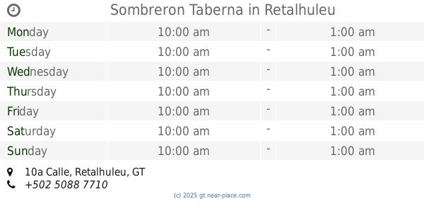
Sombreron Taberna
10a Calle, Retalhuleu
Bar
read more
49.151 km
Sport Bar La Carreta
5a Calle, Retalhuleu
Bar
read more
52.719 km
Planetarios Café Bar
Huehuetenango
Bar
read more
52.977 km
Cantina Junior
7a Calle, Huehuetenango
Bar
read more
53.205 km
Café Bar Mam Boo
1, Huehuetenango
Bar
read more
56.897 km
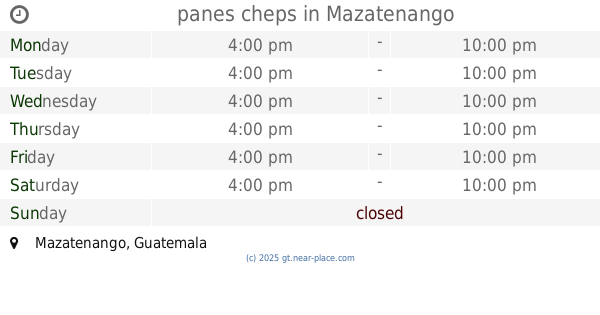
panes cheps
Mazatenango
Bar
read more
57.217 km
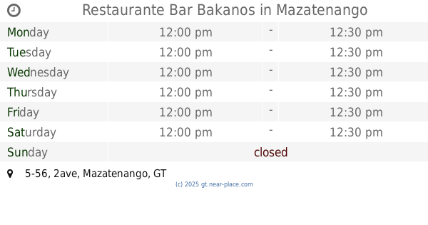
Restaurante Bar Bakanos
2ave 5-56, Mazatenango
Bar
read more
57.297 km
Quiubo Cuaz
13 Calle, Mazatenango
Bar
read more
📑
all categories
Accounting
Administrative area level 1
Administrative area level 2
Airport
Amusement park
Aquarium
Art gallery
Atm
Bakery
Bank
Bar
Beauty salon
Bicycle store
Book store
Bowling alley
Bus station
Cafe
Campground
Car dealer
Car rental
Car repair
Car wash
Casino
Cemetery
Church
City hall
Clothing store
Colloquial area
Convenience store
Courthouse
Dentist
Department store
Doctor
Electrician
Electronics store
Embassy
Establishment
Finance
Fire station
Florist
Food
Funeral home
Furniture store
Gas station
General contractor
Grocery or supermarket
Gym
Hair care
Hardware store
Health
Hindu Temple
Home goods store
Hospital
Insurance agency
Jewelry store
Laundry
Lawyer
Library
Liquor store
Local government office
Locality
Locksmith
Lodging
Meal delivery
Meal takeaway
Mosque
Movie rental
Movie theater
Moving company
Museum
Natural feature
Neighborhood
Night club
Painter
Park
Parking
Pet store
Pharmacy
Physiotherapist
Place of worship
Plumber
Point of interest
Police
Political
Post office
Premise
Real estate agency
Restaurant
Route
Rv park, camping
School
Shoe store
Shopping mall
Spa
Stadium
Storage
Store
Subway station
Supermarket
Synagogue
Taxi stand
Train station
Transit station
Travel agency
University
Veterinary care
Zoo
administrative area level 3
sublocality level 1
↑