Bar nearby Inter Sports Drinks
Guatemala
Bar nearby Inter Sports Drinks
Inter Sports Drinks
10 90, 1 Calle, Estanzuela Guatemala
contacts phone
:
+502
Latitude:
14.5636203
, Longitude:
-89.3525345
read more
nearest Bar
742 m
DKdas
3a. Calle, Esquipulas
Bar
read more
28.983 km
La Estación
Jocotan
Bar
read more
32.846 km
la bodeguita sport bar
5-73 1, 2 Avenida, Chiquimula
Bar
read more
33.329 km
La Taberna
5a. Calle, Chiquimula
Bar
read more
33.482 km
Cantina Los Amigos
9a Avenida, Chiquimula
Bar
read more
33.527 km
Mayarlin
Colonia El Milagro, 10a. Avenida, Chiquimula
Bar
read more
33.57 km
Kenkes Bar
5a. Calle, Chiquimula
Bar
read more
33.65 km
Cantina Doña Carmelina
2a. Avenida, Chiquimula
Bar
read more
33.653 km
Cantina La Central
2a Calle, Chiquimula
Bar
read more
33.654 km
LA BODEGUITA
Chiquimula
Bar
read more
33.756 km
Poncho Sport Bar
3 Avenida colonia El Caminero Zona 4, Chiquimula
Bar
read more
33.812 km
Mestizo Fast Food & Drink
5-80 Chiquimula, 1a. Calle, Chiquimula
Bar
read more
33.817 km
Los Tarros, Snak´s Bar
Barrio Sasmó Arriba
Bar
read more
33.913 km
Pulperia Roly
Chiquimula
Bar
read more
33.919 km
Tertulias Café Bar & Lounge
00-11 5, 3 Avenida, Chiquimula
Bar
read more
34.224 km
Bar El Pime
4 calle A 3-70 Zona 3 Col. San Francisco
Bar
read more
34.235 km
Bar El Pime
Unnamed Road
Bar
read more
45.321 km
Donde Chicho
La Unión
Bar
read more
48.89 km
Night Club Panamericano
Asunción Mita
Bar
read more
49.226 km
Super Tienda de Licores
2da. Avenida, 10, 88 Zona, 2
Bar
read more
49.395 km
90 minutos Sport Bar
5a. Calle, Zacapa
Bar
read more
49.541 km
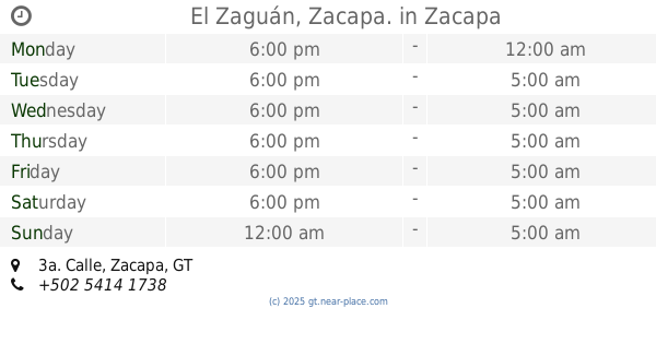
El Zaguán, Zacapa.
3a. Calle, Zacapa
Bar
read more
50.78 km
Cantina LA CEIBITA
Interamerican Highway, Tiucal
Bar
read more
59.963 km
Bar Los Conejos
Unnamed Road, Atescatempa
Bar
read more
62.476 km
Rancho Los Primos
23, Yupiltepeque
Bar
read more
📑
all categories
Accounting
Administrative area level 1
Administrative area level 2
Airport
Amusement park
Aquarium
Art gallery
Atm
Bakery
Bank
Bar
Beauty salon
Bicycle store
Book store
Bowling alley
Bus station
Cafe
Campground
Car dealer
Car rental
Car repair
Car wash
Casino
Cemetery
Church
City hall
Clothing store
Colloquial area
Convenience store
Courthouse
Dentist
Department store
Doctor
Electrician
Electronics store
Embassy
Establishment
Finance
Fire station
Florist
Food
Funeral home
Furniture store
Gas station
General contractor
Grocery or supermarket
Gym
Hair care
Hardware store
Health
Hindu Temple
Home goods store
Hospital
Insurance agency
Jewelry store
Laundry
Lawyer
Library
Liquor store
Local government office
Locality
Locksmith
Lodging
Meal delivery
Meal takeaway
Mosque
Movie rental
Movie theater
Moving company
Museum
Natural feature
Neighborhood
Night club
Painter
Park
Parking
Pet store
Pharmacy
Physiotherapist
Place of worship
Plumber
Point of interest
Police
Political
Post office
Premise
Real estate agency
Restaurant
Route
Rv park, camping
School
Shoe store
Shopping mall
Spa
Stadium
Storage
Store
Subway station
Supermarket
Synagogue
Taxi stand
Train station
Transit station
Travel agency
University
Veterinary care
Zoo
administrative area level 3
sublocality level 1
↑