Store nearby Tienda Naty
Coronavirus disease (COVID-19) Situation
confirmed cases
1291293
deaths
20289
Guatemala
Store nearby Tienda Naty
Tienda Naty
Panzós, Guatemala
contacts phone
:
+502 3136 6723
Latitude:
15.4052398
, Longitude:
-89.6381147
larger map & directions
read more
nearest Store
13.099 km
Parqueo De Buses A Las Minas
Telemán
Store
read more
19.639 km
Comercial Lucy
Senahú
Store
read more
44.171 km
PuroSol
Guatemala
Store
read more
45.707 km
Yamaha Estanzuela
Estanzuela
Store
read more
46.334 km
Mi LLanta
Km 122 Ruta al Atlantico, Teculután
Store
read more
46.427 km
Pilsaza S.A.
Estanzuela
Store
read more
46.788 km
Tienda Claro Teculutan
7a. Avenida y 2a. Calle, Zona 1, Teculután
Store
read more
46.826 km
occidental
Carretera Jacobo Árbenz Guzmán, Teculután
Store
read more
46.964 km
Pequeños Detalles, Teculután
Teculután
Store
read more
46.968 km
Piedritecu
Carretera Jacobo Árbenz Guzmán
Store
read more
47.545 km
Isuzu Guatemala
Guatemala
Store
read more
49.286 km
Imprenta Jireh
14 avenida entre segunda y, 3a. Calle, Zacapa
Store
read more
49.368 km
GSM STORE
Zacapa
Store
read more
49.375 km
IMPRENTA BATRES
3-17, 4 Calle, Estanzuela
Store
read more
49.376 km
IMPRENTA BATRES
4a. 17 Barrio la calzada Zacapa, 3 Calle, Estanzuela
Store
read more
49.383 km
Regalos Y Detalles Eterno Amor
Zacapa
Store
read more
49.389 km
SMART-CELL
4a. Calle, Zacapa
Store
read more
49.39 km
Libreria y Variedades El Éxito
Zacapa
Store
read more
49.393 km
Celtel
4a. Calle, Zacapa
Store
read more
49.43 km
Regalos Mery
5a Calle, Zacapa
Store
read more
49.525 km
MAIZA
18 Avenida, Zacapa
Store
read more
49.624 km
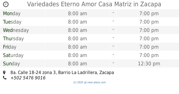
Variedades Eterno Amor Casa Matriz
8a. Calle 18-24 zona 3, Barrio La Ladrillera, Zacapa
Store
read more
49.646 km
Libreria España
Zacapa
Store
read more
49.848 km
High Q S.A
Unnamed Road
Store
read more
61.299 km
Unicell
La Unión
Store
read more
📑
all categories
Accounting
Administrative area level 1
Administrative area level 2
Airport
Amusement park
Aquarium
Art gallery
Atm
Bakery
Bank
Bar
Beauty salon
Bicycle store
Book store
Bowling alley
Bus station
Cafe
Campground
Car dealer
Car rental
Car repair
Car wash
Casino
Cemetery
Church
City hall
Clothing store
Colloquial area
Convenience store
Courthouse
Dentist
Department store
Doctor
Electrician
Electronics store
Embassy
Establishment
Finance
Fire station
Florist
Food
Funeral home
Furniture store
Gas station
General contractor
Grocery or supermarket
Gym
Hair care
Hardware store
Health
Hindu Temple
Home goods store
Hospital
Insurance agency
Jewelry store
Laundry
Lawyer
Library
Liquor store
Local government office
Locality
Locksmith
Lodging
Meal delivery
Meal takeaway
Mosque
Movie rental
Movie theater
Moving company
Museum
Natural feature
Neighborhood
Night club
Painter
Park
Parking
Pet store
Pharmacy
Physiotherapist
Place of worship
Plumber
Point of interest
Police
Political
Post office
Premise
Real estate agency
Restaurant
Route
Rv park, camping
School
Shoe store
Shopping mall
Spa
Stadium
Storage
Store
Subway station
Supermarket
Synagogue
Taxi stand
Train station
Transit station
Travel agency
University
Veterinary care
Zoo
administrative area level 3
sublocality level 1
↑