Store nearby Helados ELIDA
Guatemala
Store nearby Helados ELIDA
Helados ELIDA
Calle Transito Rojas A, Jalapa Guatemala
contacts phone
:
+502
Latitude:
14.6353277
, Longitude:
-89.9791093
read more
nearest Store
392 m
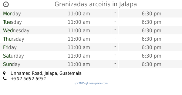
Granizadas arcoiris
Unnamed Road
Store
read more
444 m
Librería Paper
Jalapa
Store
read more
487 m
BASILIOS CAFÉ
RN-18, Jalapa
Store
read more
549 m
Apapachaditas tarjetas y mas
Calle Transito Rojas A, Jalapa
Store
read more
560 m
Librería Eloísa
Jalapa
Store
read more
759 m
Carniceria del Campo Jalapa
Jalapa
Store
read more
833 m
Libreria y papeleria macondo
Jalapa
Store
read more
995 m
Agua Pura Jumay
Avenida Chipila B, Jalapa
Store
read more
1.001 km
Lacteos De Oriente
Guatemala
Store
read more
1.057 km
MOTO REPUESTOS JALAPA
Calle Transito Rojas 1-41 Zona 05
Store
read more
1.182 km
VIALCO Vidrio Y Aluminio Cordón
Guatemala
Store
read more
1.187 km
Tienda Claro Jalapa
Calle Tránsito Rojas 5-36 Zona 6, Jalapa
Store
read more
1.187 km
Claro
Calle Tránsito Rojas 5-36 Zona 6, Jalapa
Store
read more
1.228 km
American Churros
Centro Comercial Plaza San Francisco
Store
read more
1.355 km
Curiosidades Olivitas
Jalapa
Store
read more
1.376 km
Multiservicios RC
4ta. Avenida entre 2da. y 3ra. Calle Zona 2, Barrio San Francisco Jalapa,, Jalapa
Store
read more
1.391 km
Libreria Roi
Jalapa
Store
read more
1.536 km
Barber Shop Garcia
Guatemala
Store
read more
1.697 km
Piedra Papel O Tijera
6ta Avenida, Jalapa
Store
read more
1.722 km
Helados Sarita
Jalapa
Store
read more
1.871 km
Multiceramica
2 Avenida Lote 231, Bosques de Viena, Zona 2, Jalapa
Store
read more
9.956 km
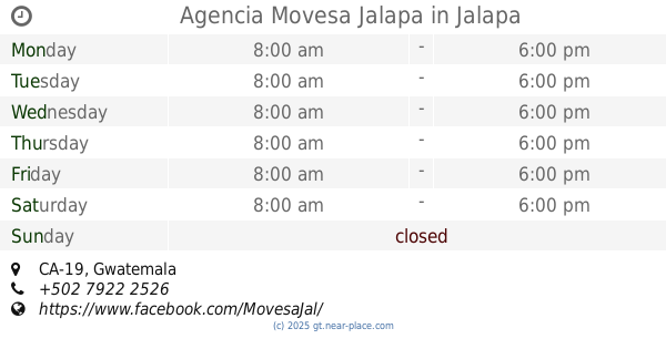
Agencia Movesa Jalapa
CA-19
Store
read more
18.683 km
FotoCel
Calzada Edin Roberto Nova, Monjas
Store
read more
19.235 km
Zona Gamer
Monjas
Store
read more
19.322 km
Heladería Sarita
Sansare
Store
read more
📑
all categories
Accounting
Administrative area level 1
Administrative area level 2
Airport
Amusement park
Aquarium
Art gallery
Atm
Bakery
Bank
Bar
Beauty salon
Bicycle store
Book store
Bowling alley
Bus station
Cafe
Campground
Car dealer
Car rental
Car repair
Car wash
Casino
Cemetery
Church
City hall
Clothing store
Colloquial area
Convenience store
Courthouse
Dentist
Department store
Doctor
Electrician
Electronics store
Embassy
Establishment
Finance
Fire station
Florist
Food
Funeral home
Furniture store
Gas station
General contractor
Grocery or supermarket
Gym
Hair care
Hardware store
Health
Hindu Temple
Home goods store
Hospital
Insurance agency
Jewelry store
Laundry
Lawyer
Library
Liquor store
Local government office
Locality
Locksmith
Lodging
Meal delivery
Meal takeaway
Mosque
Movie rental
Movie theater
Moving company
Museum
Natural feature
Neighborhood
Night club
Painter
Park
Parking
Pet store
Pharmacy
Physiotherapist
Place of worship
Plumber
Point of interest
Police
Political
Post office
Premise
Real estate agency
Restaurant
Route
Rv park, camping
School
Shoe store
Shopping mall
Spa
Stadium
Storage
Store
Subway station
Supermarket
Synagogue
Taxi stand
Train station
Transit station
Travel agency
University
Veterinary care
Zoo
administrative area level 3
sublocality level 1
↑