School nearby Escuela Jose Marti
Guatemala
School nearby Escuela Jose Marti
Escuela Jose Marti
1a Calle, Escuintla Guatemala
contacts phone
:
+502
Latitude:
14.3075491
, Longitude:
-90.7844576
read more
nearest School
135 m
Escuela la Federal
Escuintla
School
read more
165 m
Colegio Franco Americano
Escuintla
School
read more
235 m
Colegio Particular Urbano Mixto jardín de la Infancia
Escuintla
School
read more
323 m
LICEO INGLES SANTA ANA CON COMPUTACION
Escuintla
School
read more
333 m
Iglesia De Dios Misionera De Guatemala
Escuintla
School
read more
385 m
Esc.Of.Urb.de niñas #1. 15 de Sept.
1a Avenida, Escuintla
School
read more
398 m
Escuela
Colonia San Pedro El Pito
School
read more
412 m
Universidad Rural Sede 18 ESCUINTLA
Callejón de La Mielera 1a avenida zona 2 Escuintla 05002, Callejón de La Mielera 1a avenida zona 2, Escuintla
School
read more
418 m
Colegio FLC
Escuintla
School
read more
444 m
Escuela De Automovilismo Costa Sur.
1-74, 5 Calle, Escuintla
School
read more
475 m
Escuela 15 De Septiembre
escuela 15 de septiembre
School
read more
514 m
COLEGIO HIGHER LEARNING
2a.Avenida, Escuintla
School
read more
521 m
Escuela de Automovilismo San Carlos
Escuintla
School
read more
540 m
Colegio Liceo Rafael Alvarez Ovalle
Escuintla
School
read more
595 m
LICEO INTEGRAL DEL SUR DE ESCUITLA
Escuintla
School
read more
719 m
IDEAS
Escuintla
School
read more
745 m
Universidad De Occidente, Escuintla
Escuintla
School
read more
777 m
Escuela Golondrinas
Escuintla
School
read more
839 m
Fotocopias, Escuintla.
Escuintla
School
read more
839 m
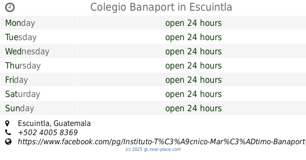
Colegio Banaport
Escuintla
School
read more
839 m
Iglesia De Cristo Ebenezer
Escuintla
School
read more
905 m
Colegio Miguel Angel Asturias
Escuintla
School
read more
998 m
Instituto Simón Bergaño y Villegas INSIBERVI
Escuintla
School
read more
1.042 km
Colegio Santiago de Los Caballeros
Escuintla
School
read more
1.316 km
Escuela Manuel Monzon Morales Canton Voladores
carretera a finca el salto primer canton voladores, Callejón, Guatemala
School
read more
📑
all categories
Accounting
Administrative area level 1
Administrative area level 2
Airport
Amusement park
Aquarium
Art gallery
Atm
Bakery
Bank
Bar
Beauty salon
Bicycle store
Book store
Bowling alley
Bus station
Cafe
Campground
Car dealer
Car rental
Car repair
Car wash
Casino
Cemetery
Church
City hall
Clothing store
Colloquial area
Convenience store
Courthouse
Dentist
Department store
Doctor
Electrician
Electronics store
Embassy
Establishment
Finance
Fire station
Florist
Food
Funeral home
Furniture store
Gas station
General contractor
Grocery or supermarket
Gym
Hair care
Hardware store
Health
Hindu Temple
Home goods store
Hospital
Insurance agency
Jewelry store
Laundry
Lawyer
Library
Liquor store
Local government office
Locality
Locksmith
Lodging
Meal delivery
Meal takeaway
Mosque
Movie rental
Movie theater
Moving company
Museum
Natural feature
Neighborhood
Night club
Painter
Park
Parking
Pet store
Pharmacy
Physiotherapist
Place of worship
Plumber
Point of interest
Police
Political
Post office
Premise
Real estate agency
Restaurant
Route
Rv park, camping
School
Shoe store
Shopping mall
Spa
Stadium
Storage
Store
Subway station
Supermarket
Synagogue
Taxi stand
Train station
Transit station
Travel agency
University
Veterinary care
Zoo
administrative area level 3
sublocality level 1
↑