School nearby Colegio Mixto Privado ASDECHI
Coronavirus disease (COVID-19) Situation
confirmed cases
1291293
deaths
20289
Guatemala
School nearby Colegio Mixto Privado ASDECHI
Colegio Mixto Privado ASDECHI
Barrio Paz y Desarrollo, Chisec Guatemala
contacts phone
:
+502
Latitude:
15.811147
, Longitude:
-90.2935593
read more
nearest School
256 m
Escuela 30 de Junio
Chisec
School
read more
301 m
ACADEMIA DE MECANOGRAFIA COMPUTARIZADA Y COMPUTACION "MIJABE"
Chisec
School
read more
698 m
INEB TS
Chisec
School
read more
998 m
Colegio cristiano Galilea
Guatemala
School
read more
3.191 km
CANAAN CHISEC ALTA VERAPAZ
15°50'21.7"N 90°17'17., 3, Nebaj
School
read more
6.993 km
Telesecundaria Canaán
Aldea Canaán,, Chisec
School
read more
7.39 km
San Jose Villa Nueva
Guatemala
School
read more
7.39 km
Liceo Tecnologico Valle De La Asuncion
Guatemala
School
read more
7.39 km
Colegio I.E.B.C C
Guatemla, Guatemala
School
read more
7.39 km
escuela lo de bran
Guatemala
School
read more
10.314 km
C.E.MONTE TRANSFIGURACION
Xuctzul
School
read more
11.925 km
Aldea Salauté
Aldea Salauté, San Pedro Carchá
School
read more
17.992 km
Sepoc El Porvenir
Guatemala
School
read more
21.693 km
Academia Nuevo Amanecer
Alta Verapaz
School
read more
21.698 km
Academia de Computación Nuevo Amanecer
Alta Verapaz
School
read more
21.849 km
Escuela Primaria De Balbatzul 2
Balbatzul 2
School
read more
22.99 km
Escuela Oficial Rural Mixta
Yalpemech, Raxruhá
School
read more
23.797 km
Escuela oficial rural mixta, Aldea Sacristal.
Aldea Sacristal,, San Pedro Carchá
School
read more
25.005 km
Aldea Setaña
Guatemala
School
read more
25.096 km
Academia de Mecanografia y Computacion "INTECAN"
Guatemala
School
read more
25.37 km
San Jose El Tesoro
Guatemala
School
read more
26.183 km
COMPUMAR
Guatemala
School
read more
27.426 km
EORM ALDEA YALCHACTI II
Guatemala
School
read more
37.901 km
En Mi Casita XD
el maestro, Cobán
School
read more
39.618 km
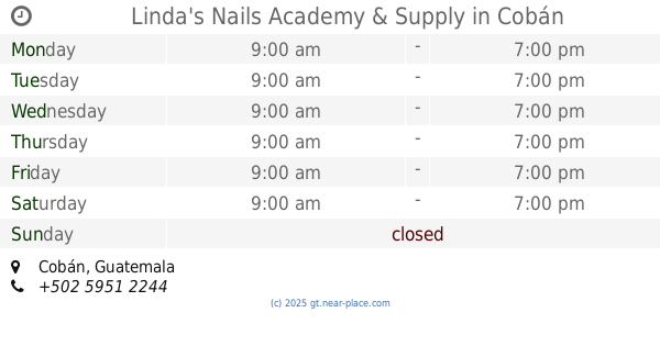
Linda's Nails Academy & Supply
Cobán
School
read more
📑
all categories
Accounting
Administrative area level 1
Administrative area level 2
Airport
Amusement park
Aquarium
Art gallery
Atm
Bakery
Bank
Bar
Beauty salon
Bicycle store
Book store
Bowling alley
Bus station
Cafe
Campground
Car dealer
Car rental
Car repair
Car wash
Casino
Cemetery
Church
City hall
Clothing store
Colloquial area
Convenience store
Courthouse
Dentist
Department store
Doctor
Electrician
Electronics store
Embassy
Establishment
Finance
Fire station
Florist
Food
Funeral home
Furniture store
Gas station
General contractor
Grocery or supermarket
Gym
Hair care
Hardware store
Health
Hindu Temple
Home goods store
Hospital
Insurance agency
Jewelry store
Laundry
Lawyer
Library
Liquor store
Local government office
Locality
Locksmith
Lodging
Meal delivery
Meal takeaway
Mosque
Movie rental
Movie theater
Moving company
Museum
Natural feature
Neighborhood
Night club
Painter
Park
Parking
Pet store
Pharmacy
Physiotherapist
Place of worship
Plumber
Point of interest
Police
Political
Post office
Premise
Real estate agency
Restaurant
Route
Rv park, camping
School
Shoe store
Shopping mall
Spa
Stadium
Storage
Store
Subway station
Supermarket
Synagogue
Taxi stand
Train station
Transit station
Travel agency
University
Veterinary care
Zoo
administrative area level 3
sublocality level 1
↑