School nearby Colegio La Montaña
Guatemala
School nearby Colegio La Montaña
Colegio La Montaña
Unnamed Road, Coatepeque, Guatemala
contacts phone
:
+502
Latitude:
14.6857168
, Longitude:
-91.8744232
larger map & directions
read more
nearest School
31 m
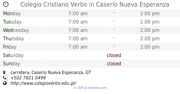
Colegio Cristiano Verbo
Km.1.2 a Nuevo Chuatuj, carretera, Caserío Nueva Esperanza
School
read more
35 m
Universidad Panamericana
Quezaltenango
School
read more
153 m
Colegio Shalom
Unnamed Road
School
read more
1.112 km
Escuela De Niños Especiales
Colonia Miguel Angel Asturias, Coatepeque
School
read more
1.283 km
Usac Coatepeque
Coatepeque
School
read more
1.532 km
Escuela Privada de Terapia Fisica y Terapia Ocupacional UdeO
Coatepeque
School
read more
1.68 km
Inocencia Lopez de Campollo
Coatepeque
School
read more
1.906 km
Escuela San Francisco
Coatepeque
School
read more
1.906 km
San Francisco School
Coatepeque
School
read more
1.917 km
Manfredo Hemerling
Coatepeque
School
read more
1.974 km
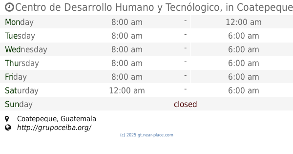
Centro de Desarrollo Humano y Tecnólogico,
Coatepeque
School
read more
1.981 km
Supervision Educativa
Coatepeque
School
read more
1.988 km
COLEGIO MINERBA
Coatepeque
School
read more
2.003 km
Colegio Liceo Infantil Minerva
0 calle Frente a Línea Ferrea, 3-24, Coatepeque
School
read more
2.143 km
Club Animis Lucidum
6a. Calle, Coatepeque
School
read more
2.146 km
Club Animis Lucidum
Coatepeque
School
read more
2.187 km
INSTITUTO PEDRO MOLINA
4ta Avenida, Coatepeque
School
read more
2.204 km
Manuel Lisandro Barillas
Coatepeque
School
read more
2.216 km
Rafael Alvarez Ovalle
Coatepeque
School
read more
2.32 km
En clave, Estudios Musicales
4ta Avenida, Coatepeque
School
read more
2.35 km
Colegio Centro Americano, Instituto Humanidades
Coatepeque
School
read more
2.404 km
IBACH
Coatepeque
School
read more
2.481 km
Colegio Evangélico Jerusalem
Coatepeque
School
read more
2.565 km
Instituto Tecnológico Privado Coatepeque
Coatepeque
School
read more
2.635 km
Colegio Cristiano La Familia
Coatepeque
School
read more
📑
all categories
Accounting
Administrative area level 1
Administrative area level 2
Airport
Amusement park
Aquarium
Art gallery
Atm
Bakery
Bank
Bar
Beauty salon
Bicycle store
Book store
Bowling alley
Bus station
Cafe
Campground
Car dealer
Car rental
Car repair
Car wash
Casino
Cemetery
Church
City hall
Clothing store
Colloquial area
Convenience store
Courthouse
Dentist
Department store
Doctor
Electrician
Electronics store
Embassy
Establishment
Finance
Fire station
Florist
Food
Funeral home
Furniture store
Gas station
General contractor
Grocery or supermarket
Gym
Hair care
Hardware store
Health
Hindu Temple
Home goods store
Hospital
Insurance agency
Jewelry store
Laundry
Lawyer
Library
Liquor store
Local government office
Locality
Locksmith
Lodging
Meal delivery
Meal takeaway
Mosque
Movie rental
Movie theater
Moving company
Museum
Natural feature
Neighborhood
Night club
Painter
Park
Parking
Pet store
Pharmacy
Physiotherapist
Place of worship
Plumber
Point of interest
Police
Political
Post office
Premise
Real estate agency
Restaurant
Route
Rv park, camping
School
Shoe store
Shopping mall
Spa
Stadium
Storage
Store
Subway station
Supermarket
Synagogue
Taxi stand
Train station
Transit station
Travel agency
University
Veterinary care
Zoo
administrative area level 3
sublocality level 1
↑