School nearby Chiquixji
Guatemala
School nearby Chiquixji
Chiquixji
Guatemala Guatemala
contacts phone
:
+502
Latitude:
15.5675492
, Longitude:
-90.2877581
read more
nearest School
1.004 km
Escuela Chicucay
Carcha, Alta Verapaz
School
read more
2.384 km
Escuela Oficial Rural Mixta Chajixim
Guatemala
School
read more
3.455 km
Instituto Básico Tanchí
Tanchí
School
read more
4.13 km
Aldea Setaña
Guatemala
School
read more
5.204 km
Pequixul Carcha
9
School
read more
5.854 km
Escuela oficial rural mixta, Aldea Sacristal.
Aldea Sacristal,, San Pedro Carchá
School
read more
9.538 km
Aldea Choval, Coban Alta Verapaz
Guatemala
School
read more
12.962 km
Potreros EFAC
Guatemala-Stadt
School
read more
12.962 km
Potreros EFAC
Gwatemala
School
read more
13.102 km
En Mi Casita XD
el maestro, Cobán
School
read more
13.2 km
Liceo Preuniversitario del Norte
3a. Avenida 8-32 zona 10, Barrio La Libertad, 3, Cobán
School
read more
13.294 km
IGER -Cobán
5a Calle 9-56 Zona 4
School
read more
13.37 km
Instituto Nornal Mixto Del Norte Emilio Rosales Ponce
Cobán
School
read more
13.465 km
Escuela Santo Tomas
Cobán
School
read more
13.685 km
Escuela De Enfermeria
6a Avenida, Cobán
School
read more
13.852 km
INSTITUO Y ACADEMIA MARIC
Cobán
School
read more
13.875 km
EORM San Luis Chicoyou
Cobán
School
read more
13.937 km
Casa Del Deportista Cobán
Cobán
School
read more
14.319 km
Particular Imperial College Mixed
1-98, 5a Calle, Cobán
School
read more
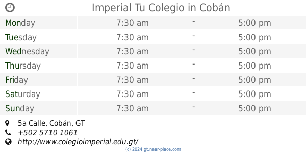
14.319 km
Imperial Tu Colegio
1-98, 5a Calle, Cobán
School
read more
14.599 km
Compucentro
Cobán
School
read more
14.61 km
Saclac,coban
Cobán
School
read more
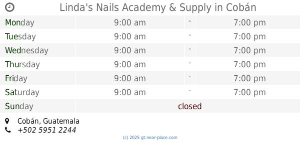
15.222 km
Linda's Nails Academy & Supply
Cobán
School
read more
16.122 km
Colegio Bilingüe Bet-Luz
Cobán
School
read more
16.994 km
Escuela O.R.M. Petet,
Cobán
School
read more
📑
all categories
Accounting
Administrative area level 1
Administrative area level 2
Airport
Amusement park
Aquarium
Art gallery
Atm
Bakery
Bank
Bar
Beauty salon
Bicycle store
Book store
Bowling alley
Bus station
Cafe
Campground
Car dealer
Car rental
Car repair
Car wash
Casino
Cemetery
Church
City hall
Clothing store
Colloquial area
Convenience store
Courthouse
Dentist
Department store
Doctor
Electrician
Electronics store
Embassy
Establishment
Finance
Fire station
Florist
Food
Funeral home
Furniture store
Gas station
General contractor
Grocery or supermarket
Gym
Hair care
Hardware store
Health
Hindu Temple
Home goods store
Hospital
Insurance agency
Jewelry store
Laundry
Lawyer
Library
Liquor store
Local government office
Locality
Locksmith
Lodging
Meal delivery
Meal takeaway
Mosque
Movie rental
Movie theater
Moving company
Museum
Natural feature
Neighborhood
Night club
Painter
Park
Parking
Pet store
Pharmacy
Physiotherapist
Place of worship
Plumber
Point of interest
Police
Political
Post office
Premise
Real estate agency
Restaurant
Route
Rv park, camping
School
Shoe store
Shopping mall
Spa
Stadium
Storage
Store
Subway station
Supermarket
Synagogue
Taxi stand
Train station
Transit station
Travel agency
University
Veterinary care
Zoo
administrative area level 3
sublocality level 1
↑