School nearby Centro Nutricional Hogar de Niños San Francisco de Asis
Guatemala
School nearby Centro Nutricional Hogar de Niños San Francisco de Asis
Centro Nutricional Hogar de Niños San Francisco de Asis
Patzún Guatemala
contacts phone
:
+502
Latitude:
14.6789964
, Longitude:
-91.0135377
read more
nearest School
304 m
Centro Educativo "Cultura y Arte"
3ª. calle 3-92 zona 1 Patzún, Chimaltenango, 1
School
read more
305 m
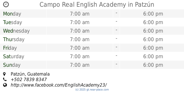
Campo Real English Academy
Patzún
School
read more
542 m
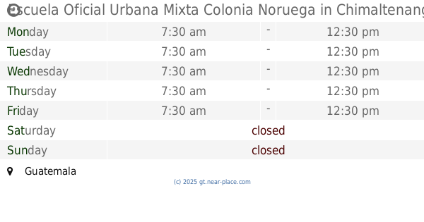
Escuela Oficial Urbana Mixta Colonia Noruega
Guatemala
School
read more
727 m
LTB Guatemalan De Patzún
Patzún
School
read more
739 m
Colegio San Bernardino
Patzún
School
read more
1.332 km
Escuela Oficial Urbana Mixta "Canton Norte"
canton norte, 3 calle
School
read more
1.382 km
IMEB PATZUN
Patzún
School
read more
4.893 km
CENTRO EDUCATIVO "VISIÓN Y FE"
ALDEA LA CANOA, PATZICIA, CHIMALTENANGO, 01
School
read more
5.735 km
Escuela Publica Caserio Xetzitzi
Caserío Xetzitzí
School
read more
8.676 km
Escuela Los Robles, San Andrés Semetabaj
School
read more
9.239 km
Escuela O.R.M
Chicacao, Godínez
School
read more
9.644 km
Escuela Oficial Rural Mixta, Pacorral Tecpan
Chimaltenango
School
read more
10.637 km
Escuela Oficial Rural Mixta "La Muchacha"
3 Calle, Patzicía
School
read more
10.728 km
Centro Educativo Zion
2 Avenida, Patzicía
School
read more
11.253 km
Centro De Aprendizaje Las Casitas
San Antonio Palopó
School
read more
12.659 km
Escuela Rural Mixta
Aldea Rincon Grande
School
read more
12.928 km
Escuela Xecohil
Chimaltenango
School
read more
13.375 km
Instituto Mixto De Educacion Basica Santa Apolonia
Santa Apolonia
School
read more
13.463 km
Escuela Mario Méndez Montenegro
Santa Apolonia
School
read more
13.686 km
Escuela Oficial De Párvulos JM, Zaragoza
2 Calle, Zaragoza
School
read more
15.054 km
La CIMA
0 calle "A", 1-47, zona 3, Comalapa
School
read more
15.098 km
Aldea Paquixic
Comalapa
School
read more
15.678 km
Liceo Nuevo Orizontee
Unnamed Road,Comalapa
School
read more
15.706 km
Colegio Fatima
Acatenango
School
read more
16.189 km
EORM COMUNIDAD CANDELARIA
PÓCHUTA
School
read more
📑
all categories
Accounting
Administrative area level 1
Administrative area level 2
Airport
Amusement park
Aquarium
Art gallery
Atm
Bakery
Bank
Bar
Beauty salon
Bicycle store
Book store
Bowling alley
Bus station
Cafe
Campground
Car dealer
Car rental
Car repair
Car wash
Casino
Cemetery
Church
City hall
Clothing store
Colloquial area
Convenience store
Courthouse
Dentist
Department store
Doctor
Electrician
Electronics store
Embassy
Establishment
Finance
Fire station
Florist
Food
Funeral home
Furniture store
Gas station
General contractor
Grocery or supermarket
Gym
Hair care
Hardware store
Health
Hindu Temple
Home goods store
Hospital
Insurance agency
Jewelry store
Laundry
Lawyer
Library
Liquor store
Local government office
Locality
Locksmith
Lodging
Meal delivery
Meal takeaway
Mosque
Movie rental
Movie theater
Moving company
Museum
Natural feature
Neighborhood
Night club
Painter
Park
Parking
Pet store
Pharmacy
Physiotherapist
Place of worship
Plumber
Point of interest
Police
Political
Post office
Premise
Real estate agency
Restaurant
Route
Rv park, camping
School
Shoe store
Shopping mall
Spa
Stadium
Storage
Store
Subway station
Supermarket
Synagogue
Taxi stand
Train station
Transit station
Travel agency
University
Veterinary care
Zoo
administrative area level 3
sublocality level 1
↑