Restaurant nearby Taco Bell
Guatemala
Restaurant nearby Taco Bell
Taco Bell
Retalhuleu, Guatemala
contacts phone
:
+502 2202 0000
website:
tacobell-retalhuleu.negocio.site
Latitude:
14.5316618
, Longitude:
-91.6815147
larger map & directions
read more
nearest Restaurant
66 m
La Proa
Retalhuleu
Restaurant
read more
91 m
El Pinche Taqueria
Retalhuleu
Restaurant
read more
155 m
McDonald's
5a. Avenida A, Retalhuleu
Restaurant
read more
212 m
Restaurant Maxim´s Retalhuleu
5a. Avenida A, Retalhuleu
Restaurant
read more
249 m
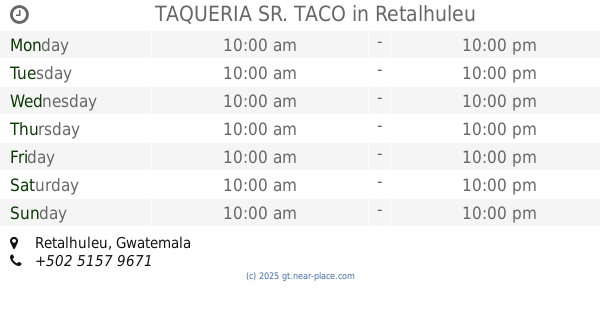
TAQUERIA SR. TACO
Retalhuleu
Restaurant
read more
372 m
Pollo Express
Retalhuleu
Restaurant
read more
386 m
Restaurante Le' Mus
2a. Calle, Retalhuleu
Restaurant
read more
564 m
Granizadas Uff
Retalhuleu
Restaurant
read more
663 m
Restaurante El Patio
4a Avenida, Retalhuleu
Restaurant
read more
665 m
García's Retro Restaurant
6ta. Calle, Retalhuleu
Restaurant
read more
683 m
Chirimulla Guillermo Restaurante
9a Avenida, Retalhuleu
Restaurant
read more
698 m
Cevichería El Pulpo
Retalhuleu
Restaurant
read more
726 m
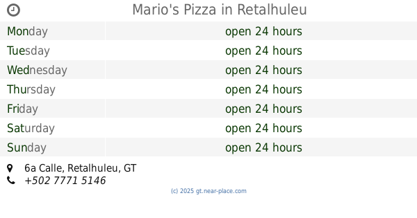
Mario's Pizza
6a Calle, Retalhuleu
Restaurant
read more
732 m
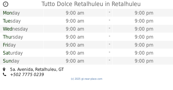
Tutto Dolce Retalhuleu
A, 5a. Avenida, Retalhuleu
Restaurant
read more
763 m
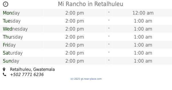
Mi Rancho
Retalhuleu
Restaurant
read more
797 m
La Tertulia
6a. Calle "A", Retalhuleu
Restaurant
read more
837 m
Tortas Mexicanas M&E
Retalhuleu
Restaurant
read more
859 m
Restaurante Flor Azul
Av. Circunvalación 6-36 Zona 6, Retalhuleu
Restaurant
read more
994 m
Casa Al Carbon
Retalhuleu
Restaurant
read more
1.006 km
Tortas Mexicanas
2a. Avenida, Retalhuleu
Restaurant
read more
1.011 km
El Taquito Express
Retalhuleu
Restaurant
read more
1.039 km
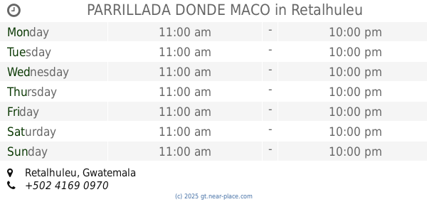
PARRILLADA DONDE MACO
Retalhuleu
Restaurant
read more
1.152 km
Juan Carnitas
Retalhuleu
Restaurant
read more
1.163 km
Las Brasas
Retalhuleu
Restaurant
read more
1.171 km
Cevicheria Sol y Palmas
7ma Avenida Zona 1, Calzada Las Palmas
Restaurant
read more
📑
all categories
Accounting
Administrative area level 1
Administrative area level 2
Airport
Amusement park
Aquarium
Art gallery
Atm
Bakery
Bank
Bar
Beauty salon
Bicycle store
Book store
Bowling alley
Bus station
Cafe
Campground
Car dealer
Car rental
Car repair
Car wash
Casino
Cemetery
Church
City hall
Clothing store
Colloquial area
Convenience store
Courthouse
Dentist
Department store
Doctor
Electrician
Electronics store
Embassy
Establishment
Finance
Fire station
Florist
Food
Funeral home
Furniture store
Gas station
General contractor
Grocery or supermarket
Gym
Hair care
Hardware store
Health
Hindu Temple
Home goods store
Hospital
Insurance agency
Jewelry store
Laundry
Lawyer
Library
Liquor store
Local government office
Locality
Locksmith
Lodging
Meal delivery
Meal takeaway
Mosque
Movie rental
Movie theater
Moving company
Museum
Natural feature
Neighborhood
Night club
Painter
Park
Parking
Pet store
Pharmacy
Physiotherapist
Place of worship
Plumber
Point of interest
Police
Political
Post office
Premise
Real estate agency
Restaurant
Route
Rv park, camping
School
Shoe store
Shopping mall
Spa
Stadium
Storage
Store
Subway station
Supermarket
Synagogue
Taxi stand
Train station
Transit station
Travel agency
University
Veterinary care
Zoo
administrative area level 3
sublocality level 1
↑