Restaurant nearby Taco Bell
Guatemala
Restaurant nearby Taco Bell
Taco Bell
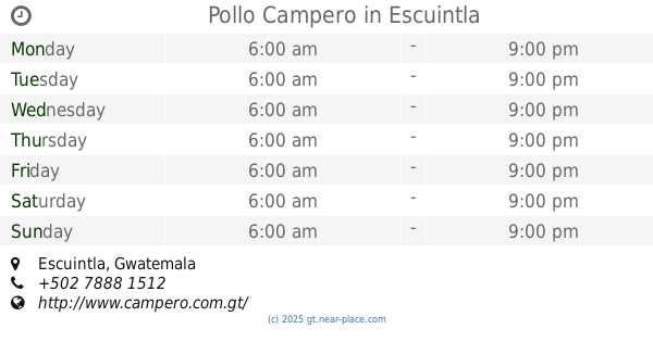
auyopista, Escuintla Gwatemala
contacts phone
:
+502
Latitude:
14.2939464
, Longitude:
-90.7990683
read more
nearest Restaurant
22 m
Lai Lai Interplaza Escuintla
Guatemala
Restaurant
read more
25 m
Los Cebollines
km.60, Centro Comercial Interplaza, Escuintla
Restaurant
read more
33 m
Pollo Campero
Escuintla
Restaurant
read more
96 m
Chili's
km, 60, 5 autopista, Palín
Restaurant
read more
1.185 km
El Viajero
Carretera Hacia Mazatenango, Escuintla
Restaurant
read more
1.413 km
Antojitos Gaby
Escuintla
Restaurant
read more
1.431 km
El Comedor
9-36, 2a.Avenida, Escuintla
Restaurant
read more
1.492 km
Jacobo's Chinese Restaurant
Escuintla
Restaurant
read more
1.555 km
Restaurante China Lin
Escuintla
Restaurant
read more
1.565 km
Dominos Pizza Minuto
2a. Avenida, Escuintla
Restaurant
read more
1.6 km
EN LINEA SPORT BAR
Final, entrada a Col. El Vesubio, 4a.AVENIDA, Escuintla
Restaurant
read more
1.619 km
Panadely Café
Escuintla
Restaurant
read more
1.644 km
Rest. & Cafe La Casa De La Abuela
1a Avenida, Escuintla
Restaurant
read more
1.68 km
Comedor La Colmenita
Escuintla
Restaurant
read more
1.701 km
Don Panote
11-76, 6ta. Avenida, Escuintla
Restaurant
read more
1.711 km
Resturante Varadero
km59.5 Carretera a, Puerto San José
Restaurant
read more
1.755 km
Turicentro Palmeras
1a Avenida 3-95, Escuintla
Restaurant
read more
1.815 km
Pizzeria Ál Macarone
4a. Avenida Mercado, Escuintla
Restaurant
read more
1.92 km
La Isla Restaurante.
2a. Calle, Escuintla
Restaurant
read more
1.921 km
Jeremy Comida China A Domicilio
1-93, 4 Calle, Escuintla
Restaurant
read more
1.944 km
Al Macarone
Escuintla
Restaurant
read more
2.027 km
Gastrobar Toro Negro
Escuintla
Restaurant
read more
2.046 km
SHUKOS URBANOS
1a Avenida, Escuintla
Restaurant
read more
2.219 km
Turicentro Las Marias
Escuintla
Restaurant
read more
2.493 km
San Telmo
Avenue Centroamerica, Escuintla
Restaurant
read more
📑
all categories
Accounting
Administrative area level 1
Administrative area level 2
Airport
Amusement park
Aquarium
Art gallery
Atm
Bakery
Bank
Bar
Beauty salon
Bicycle store
Book store
Bowling alley
Bus station
Cafe
Campground
Car dealer
Car rental
Car repair
Car wash
Casino
Cemetery
Church
City hall
Clothing store
Colloquial area
Convenience store
Courthouse
Dentist
Department store
Doctor
Electrician
Electronics store
Embassy
Establishment
Finance
Fire station
Florist
Food
Funeral home
Furniture store
Gas station
General contractor
Grocery or supermarket
Gym
Hair care
Hardware store
Health
Hindu Temple
Home goods store
Hospital
Insurance agency
Jewelry store
Laundry
Lawyer
Library
Liquor store
Local government office
Locality
Locksmith
Lodging
Meal delivery
Meal takeaway
Mosque
Movie rental
Movie theater
Moving company
Museum
Natural feature
Neighborhood
Night club
Painter
Park
Parking
Pet store
Pharmacy
Physiotherapist
Place of worship
Plumber
Point of interest
Police
Political
Post office
Premise
Real estate agency
Restaurant
Route
Rv park, camping
School
Shoe store
Shopping mall
Spa
Stadium
Storage
Store
Subway station
Supermarket
Synagogue
Taxi stand
Train station
Transit station
Travel agency
University
Veterinary care
Zoo
administrative area level 3
sublocality level 1
↑