Restaurant nearby Restaurante Guanabas disco
Guatemala
Restaurant nearby Restaurante Guanabas disco
Restaurante Guanabas disco
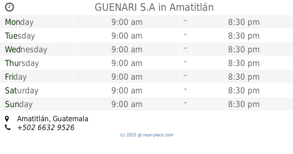
Amatitlán Guatemala
contacts phone
:
+502
Latitude:
14.4773024
, Longitude:
-90.634631
read more
nearest Restaurant
791 m
Al Macarone Flores del Lago
Amatitlán
Restaurant
read more
811 m
Taco Bell
Centro Comercial Las Flores del Lago, Carretera 9, Amatitlán
Restaurant
read more
832 m
GUENARI S.A
Amatitlán
Restaurant
read more
850 m
Taco Bell
Amatitlán
Restaurant
read more
872 m
SUBWAY
Amatitlán
Restaurant
read more
901 m
Pollo Campero
Carretera CA-9, Amatitlán
Restaurant
read more
935 m
Lai Lai
Amatitlán
Restaurant
read more
962 m
Los Cebollines
Carretera CA-9, Amatitlán
Restaurant
read more
997 m
Panes El Tesorito
7 Calle, Amatitlán
Restaurant
read more
1.083 km
Guate Burger
Amatitlán
Restaurant
read more
1.111 km
Pollo Pinulito
5ta. Avenida, Amatitlán
Restaurant
read more
1.36 km
Brontoburguer
8 Calle, Amatitlán
Restaurant
read more
1.514 km
Café del Bosque
6 Calle, Amatitlán
Restaurant
read more
1.544 km
Pollo Campero
Amatitlán
Restaurant
read more
1.587 km
Poio Pollo Amatitlan
5_66, 2 Avenida, Amatitlán
Restaurant
read more
1.592 km
Quedely
3 Avenida, Amatitlán
Restaurant
read more
1.656 km
Tortilleria Los Trestiempos Y Churrasquitos
4-25 Bartio San Juan, 4 Calle, Amatitlán
Restaurant
read more
1.678 km
Dominos Pizza
Amatitlán
Restaurant
read more
1.744 km
Pollo Pinulito
2 Avenida, Amatitlán
Restaurant
read more
1.839 km
Comedor Negris
Amatitlán
Restaurant
read more
1.855 km
Taquería El Camioncito
Amatitlán
Restaurant
read more
1.92 km
Panes El Tesorito
3 Avenida, Amatitlán
Restaurant
read more
1.995 km
Pupusería El Deportivo
5ta. Avenida, Amatitlán
Restaurant
read more
2.096 km
Restaurante Amatitlan
3 Avenida, Amatitlán
Restaurant
read more
2.101 km
Chivas Steak House Casa Del Lago Amatitlán
Amatitlán
Restaurant
read more
📑
all categories
Accounting
Administrative area level 1
Administrative area level 2
Airport
Amusement park
Aquarium
Art gallery
Atm
Bakery
Bank
Bar
Beauty salon
Bicycle store
Book store
Bowling alley
Bus station
Cafe
Campground
Car dealer
Car rental
Car repair
Car wash
Casino
Cemetery
Church
City hall
Clothing store
Colloquial area
Convenience store
Courthouse
Dentist
Department store
Doctor
Electrician
Electronics store
Embassy
Establishment
Finance
Fire station
Florist
Food
Funeral home
Furniture store
Gas station
General contractor
Grocery or supermarket
Gym
Hair care
Hardware store
Health
Hindu Temple
Home goods store
Hospital
Insurance agency
Jewelry store
Laundry
Lawyer
Library
Liquor store
Local government office
Locality
Locksmith
Lodging
Meal delivery
Meal takeaway
Mosque
Movie rental
Movie theater
Moving company
Museum
Natural feature
Neighborhood
Night club
Painter
Park
Parking
Pet store
Pharmacy
Physiotherapist
Place of worship
Plumber
Point of interest
Police
Political
Post office
Premise
Real estate agency
Restaurant
Route
Rv park, camping
School
Shoe store
Shopping mall
Spa
Stadium
Storage
Store
Subway station
Supermarket
Synagogue
Taxi stand
Train station
Transit station
Travel agency
University
Veterinary care
Zoo
administrative area level 3
sublocality level 1
↑